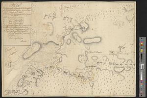
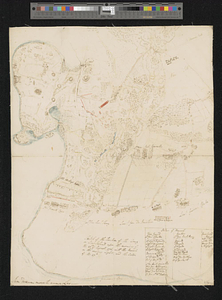
Sketch of the position of the army on Long Island upon the morning of the 26th of August, 1776; with the march on the ensuing night; and the action of the 27th
This map is also available in American Revolutionary Geographies Online (ARGO), a collections portal especially built for material relating to the American Revolutionary War Era. Visit ARGO to learn more about this item and explore the historical geography of North America in the late eighteenth century.
Item Information
- Title:
- Sketch of the position of the army on Long Island upon the morning of the 26th of August, 1776; with the march on the ensuing night; and the action of the 27th
- Contributor:
- Hastings, Francis Rawdon-Hastings, Marquess of, 1754-1826
- Date:
-
1776
- Format:
-
Maps/Atlases
- Genre:
-
Manuscript maps
- Location:
- William L. Clements Library
- Collection (local):
-
William L. Clements Library Collection
- Subjects:
-
Long Island, Battle of, New York, N.Y., 1776--Maps
Long Island (N.Y.)--Maps
United States--History--Revolution, 1775-1783--Maps
- Places:
-
New YorkLong Island (island)
- Extent:
- 1 ms. map : outline col. ; 40.5 x 32 cm
- Terms of Use:
-
The University of Michigan Library provides access to these materials for educational and research purposes. These materials may be under copyright. If you decide to use any of these materials, you are responsible for making your own legal assessment and securing any necessary permission. If you have questions about the collection, please contact the William L. Clements Library.
Contact host institution for more information.
- Scale:
-
Scale [ca. 1:24,000].
- Language:
-
English
- Catalog Record:
-
Catalog record
- Notes:
-
Finished topographical map of the western end of Long Island, showing in detail movements of troops during one phase of the Battle of Long Island.
Separate table gives order of march for British units involved in flanking movement.
The following is written in the hand of Lord Francis Rawdon: Iam demum movet arma Leo.
Clinton Maps 133.
- Identifier:
-
200
- Barcode:
-
B1936380