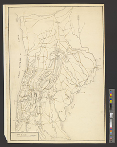
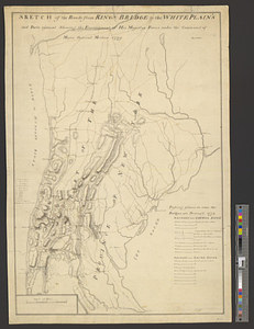
Sketch of the roads from Kings Bridge to the White Plains and parts ajacent shewing the encampment of his majestys forces under the command of Major General Mathew 1779
This map is also available in American Revolutionary Geographies Online (ARGO), a collections portal especially built for material relating to the American Revolutionary War Era. Visit ARGO to learn more about this item and explore the historical geography of North America in the late eighteenth century.
Item Information
- Title:
- Sketch of the roads from Kings Bridge to the White Plains and parts ajacent shewing the encampment of his majestys forces under the command of Major General Mathew 1779
- Creator:
- Hills, John, active 1777-1819
- Name on Item:
-
by I. Hills
- Date:
-
1779
- Format:
-
Maps/Atlases
- Genre:
-
Manuscript maps
- Location:
- William L. Clements Library
- Collection (local):
-
William L. Clements Library Collection
- Subjects:
-
Westchester County (N.Y.)--Maps
United States--History--Revolution, 1775-1783--Maps
Mathew, Edward
- Places:
-
New YorkWestchester (county)
- Extent:
- 1 ms. map : outline col. ; 61.4 x 40.5 cm.
- Terms of Use:
-
The University of Michigan Library provides access to these materials for educational and research purposes. These materials may be under copyright. If you decide to use any of these materials, you are responsible for making your own legal assessment and securing any necessary permission. If you have questions about the collection, please contact the William L. Clements Library.
Contact host institution for more information.
- Scale:
-
Scale 1:85,000.
- Language:
-
English
- Catalog Record:
-
Catalog record
- Notes:
-
Finished, topographical map of the region from the Hudson River on the west to the town of Rye on the east and from "Spiken Devil" Creek on the south to Teller's Point on the north.
A table of references identifies units involved in the operation and another table at right provides information on ways to cross waterways should the bridges be destroyed.
Clinton Map 153.
- Identifier:
-
585
- Barcode:
-
B2821955