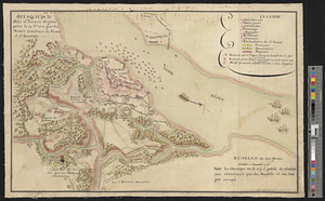
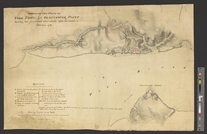
Sketch of the posts of York Town and Gloucester Point shewing the French and rebel attacks upon the former in October, 1781
This map is also available in American Revolutionary Geographies Online (ARGO), a collections portal especially built for material relating to the American Revolutionary War Era. Visit ARGO to learn more about this item and explore the historical geography of North America in the late eighteenth century.
Item Information
- Title:
- Sketch of the posts of York Town and Gloucester Point shewing the French and rebel attacks upon the former in October, 1781
- Creator:
- Sutherland, Alexr. (Alexander)
- Date:
-
[1781]
- Format:
-
Maps/Atlases
- Genre:
-
Manuscript maps
- Location:
- William L. Clements Library
- Collection (local):
-
William L. Clements Library Collection
- Subjects:
-
Yorktown (Va.)--Maps
Yorktown (Va.)--History--Siege, 1781--Maps
United States--History--Revolution, 1775-1783--Maps
- Places:
-
VirginiaYork (county)Yorktown
- Extent:
- 1 ms. map : col. ; 47.3 x 68 cm.
- Terms of Use:
-
The University of Michigan Library provides access to these materials for educational and research purposes. These materials may be under copyright. If you decide to use any of these materials, you are responsible for making your own legal assessment and securing any necessary permission. If you have questions about the collection, please contact the William L. Clements Library.
Contact host institution for more information.
- Scale:
-
Scale 1:10,800.
- Language:
-
English
- Catalog Record:
-
Catalog record
- Notes:
-
Finished, colored, topographical plan of the British posts on both sides of the York River.
Table of references identifies features of fortifications.
Four additional redoubts added at Yorktown in another hand with corresponding addition to table of references suggesting that they would have improved the position.
Clinton Maps 270.
- Notes (date):
-
This date is inferred.
- Identifier:
-
757
- Barcode:
-
B1937166