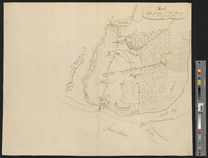
Sketch of the position of the British forces at Elizabeth Town Point after their return from Connecticut Farm, in the province of East Jersey: under the command of his excelly. Leiutt. [sic] Genl. Knyphausen, on the 8th June 1780
![Sketch of the position of the British forces at Elizabeth Town Point after their return from Connecticut Farm, in the province of East Jersey: under the command of his excelly. Leiutt. [sic] Genl. Knyphausen, on the 8th June 1780](https://bpldcassets.blob.core.windows.net/derivatives/images/commonwealth:z603vn418/image_access_800.jpg)
This map is also available in American Revolutionary Geographies Online (ARGO), a collections portal especially built for material relating to the American Revolutionary War Era. Visit ARGO to learn more about this item and explore the historical geography of North America in the late eighteenth century.
Item Information
- Title:
- Sketch of the position of the British forces at Elizabeth Town Point after their return from Connecticut Farm, in the province of East Jersey: under the command of his excelly. Leiutt. [sic] Genl. Knyphausen, on the 8th June 1780
- Creator:
- Hills, John, (Surveyor)
- Contributor:
- Faden, William, 1750?-1836
- Name on Item:
-
by John Hills, lieut. 23d. Regt. & asst. engr.
- Date:
-
1784
- Format:
-
Maps/Atlases
- Location:
- Newberry Library
- Collection (local):
-
Newberry Library Collection
- Subjects:
-
Elizabeth (N.J.)--Maps
Springfield, N.J., Battle of, 1780--Maps
United States--History--Revolution, 1775-1783--Maps
- Places:
-
New JerseyUnion (county)Springfield
New JerseyUnion (county)Elizabeth
- Extent:
- 1 map : col. ; 62 x 52 cm.
- Terms of Use:
-
No known copyright restrictions.
Contact host institution for more information.
- Publisher:
-
London :
Willm. Faden, Charing Cross
- Scale:
-
Scale ca. 1:7,100
- Language:
-
English
- Catalog Record:
-
https://i-share-nby.primo.exlibrisgroup.com/permalink/01CARLI_NBY/i5mcb2/alma998935858805867
- Notes:
-
Shows fortifications, bridge of boats, and positions of individual British units during their retreat to Staten Island.
Oriented with north at right.
Relief shown by shading.
Table of references provides further information.
Detached from: Faden, William, [Atlas of battle plans, ca. 1783], no. 25.
The atlas was previously owned by British general Sir Henry Clinton.
- Call #:
-
Map4F 3701.S3.25 (PrCt)