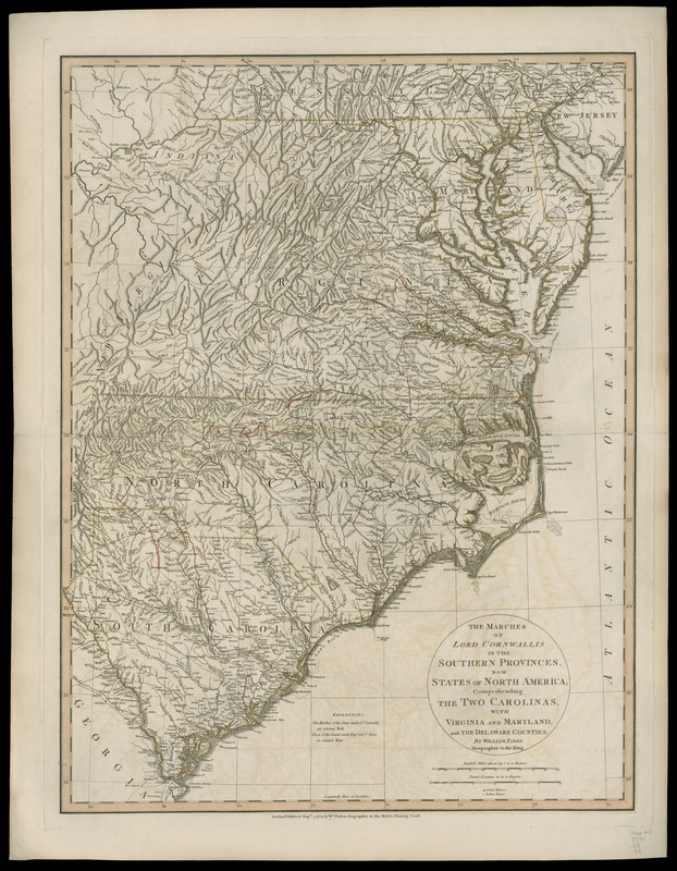
The marches of Lord Cornwallis in the Southern Provinces, now states of North America : comprehending the two Carolinas, with Virginia and Maryland, and the Delaware counties
This map is also available in American Revolutionary Geographies Online (ARGO), a collections portal especially built for material relating to the American Revolutionary War Era. Visit ARGO to learn more about this item and explore the historical geography of North America in the late eighteenth century.
Item Information
- Title:
- The marches of Lord Cornwallis in the Southern Provinces, now states of North America : comprehending the two Carolinas, with Virginia and Maryland, and the Delaware counties
- Creator:
- Faden, William, 1749-1836
- Date:
-
1783
- Format:
-
Maps/Atlases
Manuscripts
- Location:
- Newberry Library
- Collection (local):
-
Newberry Library Collection
- Subjects:
-
Southern States--History--Revolution, 1775-1783--Maps
United States--History--Revolution, 1775-1783--Maps
- Places:
-
Southern United States (area)
- Extent:
- 1 map : hand col. ; 65 x 49 cm.
- Terms of Use:
-
No known copyright restrictions.
Contact host institution for more information.
- Publisher:
-
London :
Wm. Faden
- Scale:
-
Scale [ca. 1:1,525,000]
- Catalog Record:
-
https://i-share-nby.primo.exlibrisgroup.com/permalink/01CARLI_NBY/i5mcb2/alma999042848805867
- Notes:
-
First state.
Prime meridian: London.
Pictorial relief.
Designed to show O'Hara's route in blue. This copy lacks blue coloring.
Detached from: Faden, William, [Atlas of battle plans, ca. 1783], no. 26.
The atlas was previously owned by British general Sir Henry Clinton.
- Call #:
-
Map4F 3701.S3.26 (PrCt)
![Sketch of the position of the British forces at Elizabeth Town Point after their return from Connecticut Farm, in the province of East Jersey: under the command of his excelly. Leiutt. [sic] Genl. Knyphausen, on the 8th June 1780](https://bpldcassets.blob.core.windows.net/derivatives/images/commonwealth:z603vn418/image_thumbnail_300.jpg)


