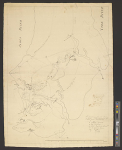
A sketch of the east end of the peninsula where on is Hampton
This map is also available in American Revolutionary Geographies Online (ARGO), a collections portal especially built for material relating to the American Revolutionary War Era. Visit ARGO to learn more about this item and explore the historical geography of North America in the late eighteenth century.
Item Information
- Title:
- A sketch of the east end of the peninsula where on is Hampton
- Creator:
- M., W. P.
- Name on Item:
-
W.P.M.
- Date:
-
[1781]
- Format:
-
Maps/Atlases
- Genre:
-
Manuscript maps
- Location:
- William L. Clements Library
- Collection (local):
-
William L. Clements Library Collection
- Subjects:
-
Hampton (Va.)--Maps
Old Point Comfort (Va.)--Maps
Elizabeth City County (Va.)--Maps
United States--History--Revolution, 1775-1783--Maps
- Places:
-
VirginiaHampton
VirginiaOld Point Comfort
- Extent:
- 1 ms. map ; 72.4 x 52 cm.
- Terms of Use:
-
The University of Michigan Library provides access to these materials for educational and research purposes. These materials may be under copyright. If you decide to use any of these materials, you are responsible for making your own legal assessment and securing any necessary permission. If you have questions about the collection, please contact the William L. Clements Library.
Contact host institution for more information.
- Scale:
-
Scale 1:50,000.
- Language:
-
English
- Catalog Record:
-
Catalog record
- Notes:
-
Finished, topographical, pen and ink map of the area within about a 12-mile radius of Hampton, Virginia.
Shows basic town plan of Hampton.
The roads and principal plantations are shown, some with their names or those of their owners, and a number of structures are rendered pictorially.
A brief table of references identifies important points, particularly those relating to the military occupation.
Endorsed on verso: Lt. Colonel De Lancey, G.: B: N.Y. April 15th, 1782.
Clinton Maps 263.
- Notes (date):
-
This date is inferred.
- Identifier:
-
577
- Barcode:
-
B2625557


