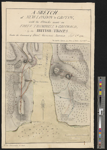
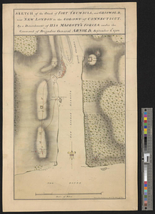
Sketch of the attack of Fort Trumbull, and Griswold, near New London in the colony of Connecticut, by a detachment of his majesty's forces under the command of Brigadier General Arnold, September 6th, 1781
This map is also available in American Revolutionary Geographies Online (ARGO), a collections portal especially built for material relating to the American Revolutionary War Era. Visit ARGO to learn more about this item and explore the historical geography of North America in the late eighteenth century.
Item Information
- Title:
- Sketch of the attack of Fort Trumbull, and Griswold, near New London in the colony of Connecticut, by a detachment of his majesty's forces under the command of Brigadier General Arnold, September 6th, 1781
- Creator:
- Hills, John, active 1777-1819
- Date:
-
[1781]
- Format:
-
Maps/Atlases
- Genre:
-
Manuscript maps
- Location:
- William L. Clements Library
- Collection (local):
-
William L. Clements Library Collection
- Subjects:
-
Groton Heights, Battle of, Conn., 1781--Maps
New London (Conn.)--Maps
Fort Trumbull (New London, Conn. : Fort)--Maps
Fort Griswold (Groton, Conn.)--Maps
United States--History--Revolution, 1775-1783--Maps
Arnold, Benedict, 1741-1801
- Places:
-
ConnecticutNew London (county)New London
ConnecticutNew London (county)Groton
Fort Trumbull
Fort Griswold (historical)
- Extent:
- 1 ms. map : col. ; 44.5 x 26.4 cm.
- Terms of Use:
-
The University of Michigan Library provides access to these materials for educational and research purposes. These materials may be under copyright. If you decide to use any of these materials, you are responsible for making your own legal assessment and securing any necessary permission. If you have questions about the collection, please contact the William L. Clements Library.
Contact host institution for more information.
- Scale:
-
Scale 1:21,500.
- Language:
-
English
- Catalog Record:
-
Catalog record
- Notes:
-
Signed within neat line at lower right: Copied from the original sketch by I. Hills asst. engr.
Finished, colored, topographical map of both shores of the mouth of the Thames River showing the landing places and movements of British troops involved in the operation.
British units identified by symbol and by number or name.
See also Lyman, A sketch of New-London & Groton, which is similar and from which this map might have been copied.
Clinton Map 108.
- Notes (date):
-
This date is inferred.
- Identifier:
-
598
- Barcode:
-
B2850181