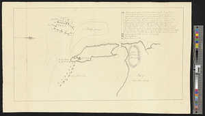
A sketch of the disposition of the force at New York for the defence of the port
This map is also available in American Revolutionary Geographies Online (ARGO), a collections portal especially built for material relating to the American Revolutionary War Era. Visit ARGO to learn more about this item and explore the historical geography of North America in the late eighteenth century.
Item Information
- Title:
- A sketch of the disposition of the force at New York for the defence of the port
- Date:
-
[1779]
- Format:
-
Maps/Atlases
- Genre:
-
Manuscript maps
- Location:
- William L. Clements Library
- Collection (local):
-
William L. Clements Library Collection
- Subjects:
-
Sandy Hook (N.J.)--Maps
New York Harbor (N.Y. and N.J.)--Maps
United States--History--Revolution, 1775-1783--Maps
- Places:
-
New JerseyMonmouth (county)Sandy Hook (cape)
- Extent:
- 1 ms. map : outline col. ; 25.2 x 45.2 cm.
- Terms of Use:
-
The University of Michigan Library provides access to these materials for educational and research purposes. These materials may be under copyright. If you decide to use any of these materials, you are responsible for making your own legal assessment and securing any necessary permission. If you have questions about the collection, please contact the William L. Clements Library.
Contact host institution for more information.
- Scale:
-
Scale ca. 1:42,240.
- Language:
-
English
- Catalog Record:
-
Catalog record
- Notes:
-
Title taken from verso.
Finished, pen and ink map of Sandy Hook and its immediate area showing the position of the British vessels defending the harbor in October 1779.
Part of the contemplated defense is described in a table of references, and a number of the vessels are named.
- Notes (date):
-
This date is inferred.
- Identifier:
-
8412
- Barcode:
-
B2796979