Toggle navigation
LMEC Home
Exhibitions
Georeferencing
Tools for Teachers
Collections
My Favorites
Sign Up / Log In
Search
Search the map portal
Map Collection
Map Collection
Map Sets
Search
Search
Search for
Search In
All Fields
Creator
Title
Subject
Place
Search All Digital Collections
Advanced Search
90 Results
My Search
Start Over
More Like
commonwealth:z603vr069
Remove constraint More Like: commonwealth:z603vr069
Filter your Search
Place
North and Central America
44
United States
37
North America
35
Southern United States
13
New Jersey
8
Northeastern United States
6
Middle Atlantic
5
North Carolina
5
more
Place
»
Topic
North America--Maps--Early works to 1800
27
United States--Maps--Early works to 1800
14
Southern States--Maps--Early works to 1800
13
Great Britain--Colonies--America--Maps--Early works to 1800
9
New Jersey--Maps--Early works to 1800
7
North America--Maps
7
Northeastern States--Maps--Early works to 1800
6
British--America--Maps--Early works to 1800
5
more
Topic
»
Date
Date range begin
–
Date range end
Current results range from
1705
to
1899
View distribution
Creator
Lodge, John, -1796
6
Gibson, J. (John), active 1750-1792
5
Hinton, John, -1781
5
Jefferys, Thomas, -1771
5
Kitchin, Thomas, 1718-1784
5
Russell, John, active 1733-1795
5
Sayer, Robert, 1725-1794
5
Anville, Jean Baptiste Bourguignon d', 1697-1782
4
more
Creator
»
Format
Maps/Atlases
90
Georeferenced
Yes
7
No
83
Collection
American Revolutionary War-Era Maps
86
New York Public Library Collection
77
Norman B. Leventhal Map & Education Center Collection
12
Richard H. Brown Revolutionary War Map Collection at Mount Vernon
1
Available to use
Creative Commons license
78
No known restrictions
12
Search Constraints
Sort by title
relevance
title
date (asc)
date (desc)
Number of results to display per page
50 per page
10
per page
20
per page
50
per page
100
per page
View results as:
grid view
map view
Search Results
51.
Map of the Southern provinces of the United States
52.
Map of the southern states of America, comprehending Maryland, Virginia, Kentucky, Territory s'th of the Ohio, North Carolina,...
53.
A map of the United States of America, as settled by the peace of 1783
54.
A map of the United States of North America : drawn from a number of critical researches
55.
Mappa geographica Americae Septentrionalis : ad emendatiora exemplaria adhuc edita jussu Acad. reg. scient. et eleg. litt....
56.
N. America
57.
A New & accurate map of North America : including the British acquisitions gained by the late war, 1763
58.
A new & accurate map of North America : drawn from the most authentic modern maps and charts
59.
New & accurate map of North America : with the new discovered islands on the north east coast of Asia
60.
A New and accurate map of New Jersey : from the best authorities
61.
A new and accurate map of North America
62.
A new and accurate map of the English empire in North America : representing their rightful claim as confirm'd by charters, and...
63.
A New and accurate map of Virginia : and part of Maryland and Pennsylvania
64.
A new and correct map of North America : in which the places of the principal engagements during the present war are accurately...
65.
A new and correct map of North America : in which the places of the principal engagements during the present war are accurately...
66.
A new and correct map of North America with the West India Islands : divided according to the last treaty of peace, concluded...
67.
A new and general map of the Southern dominions belonging to the United States of America, viz North Carolina, South Carolina,...
68.
A new chart of the coast of North America : from New York to Cape Hatteras, including the bays of Delaware and Chesapeak, with...
69.
A New map of North America with the West India Islands : divided according to the preliminary articles of peace, signed at...
70.
North America
71.
North America
72.
North America
73.
North America, agreeable to the most approved maps and charts
74.
North America, as divided amongst the European powers
75.
North America drawn from the latest and best authorities
76.
Nova tabula geographica complectens borealiorem Americae partem : in qua exacte delineatae sunt Canada sive Nova Francia, Nova...
77.
Part of North America : comprehending the course of Ohio, New England, New York, New Jersey, Pennsylvania, Maryland, Virginia,...
78.
La Pensilvania, la Nuova York, il Jersey Settentrio[na]le : con la parte occidentale del Connecticut, Massachusset-s-bay e...
79.
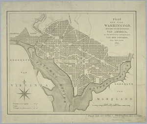
Plan der stad Washington : bestemd tot de hoofdstad van America, en ter bestendige verblijfplaats van het Congres, naa het jaar...
80.
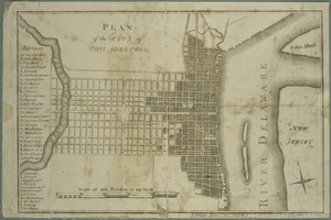
Plan of the city of Philadelphia
81.
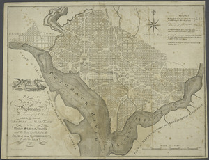
Plan of the city of Washington in the territory of Columbia : ceded by the states of Virginia and Maryland to the United States...
82.
A plan of the northern part of New Jersey : shewing the positions of the American and British armies after crossing the North...
83.
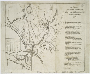
A plan of the operations of the British & Rebel army in the Campaign, 1777
84.
The Province of New Jersey : divided into East and West, commonly called the Jerseys
85.
Seat of war in the environs of Philadeliphia
86.
Seat of war in the environs of Philadeliphia
87.
The State of New Jersey : compiled from the most accurate surveys
88.
States of America, drawn from the best authorities
89.
The United States of America, according to the Treaty of Peace of 1784
90.
The United States of North America, with the British & Spanish territories according to the treaty
‹ Prev
Next ›
1
2


![La Pensilvania, la Nuova York, il Jersey Settentrio[na]le](https://bpldcassets.blob.core.windows.net/derivatives/images/commonwealth:z603vq53g/image_thumbnail_300.jpg)