Toggle navigation
LMEC Home
Exhibitions
Georeferencing
Tools for Teachers
Collections
My Favorites
Sign Up / Log In
Search
Search the map portal
Map Collection
Map Collection
Map Sets
Search
Search
Search for
Search In
All Fields
Creator
Title
Subject
Place
Search All Digital Collections
Advanced Search
214 Results
My Search
Start Over
More Like
commonwealth:z603vp26c
Remove constraint More Like: commonwealth:z603vp26c
Filter your Search
Place
North and Central America
112
North America
107
Saint Lawrence River
64
Canada
53
United States
46
Quebec
42
Longue-Pointe-de-Mingan
12
Mingan Îles de
12
more
Place
»
Topic
North America--Maps
80
Saint Lawrence River--Maps
65
North America--Maps--Early works to 1800
27
United States--History--French and Indian War, 1754-1763--Maps
24
United States--Maps--Early works to 1800
14
United States--Maps
13
Longue-Pointe (Québec)--Maps
12
Mingan Islands (Québec)--Maps
12
more
Topic
»
Date
Date range begin
–
Date range end
Current results range from
1744
to
1945
View distribution
Creator
Jefferys, Thomas, -1771
17
Robert Sayer and John Bennett (Firm)
15
Cook, James, 1728-1779
13
Desjardins, pilot of Québec
12
Saunders, Charles, Sir, 1713?-1775
12
Anville, Jean Baptiste Bourguignon d', 1697-1782
8
Kitchin, Thomas, 1718-1784
8
Holland, Samuel, 1728-1801
7
more
Creator
»
Format
Maps/Atlases
214
Manuscripts
1
Georeferenced
Yes
20
No
194
Collection
American Revolutionary War-Era Maps
169
New York Public Library Collection
79
William L. Clements Library Collection
55
Norman B. Leventhal Map Center Collection
45
American Antiquarian Society Collection
19
Library and Archives Canada Collection
14
MacLean Collection Map Library
1
Richard H. Brown Revolutionary War Map Collection at Mount Vernon
1
Available to use
Creative Commons license
81
No known restrictions
45
Search Constraints
Sort by relevance
relevance
title
date (asc)
date (desc)
Number of results to display per page
50 per page
10
per page
20
per page
50
per page
100
per page
View results as:
grid view
map view
Search Results
51.
Plan of the town of Quebec the capital of Canada in North America : with the bason and a part of the adjacent country shewing...
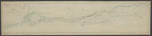
52.
Profile of the river St. Lawrence between Montreal and Quebec shewing the deepening of the ship channel
53.
Region of Gaspee Bay
54.
Region of Hare Island
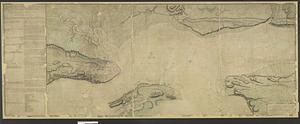
55.
The River St. Lawrence from Mal Bay to the Basin of Quebec
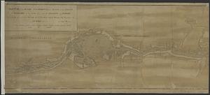
56.
The River St. Lawrence from the Basin of Quebec to the Falls of Richeu
57.
The Seven Islands and the Bay
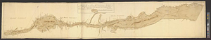
58.
The Shoals of Beauport; The River St. Lawrence from the Basin of Quebec to the Falls of Richeu
59.
Sketch of the river St Lawrence from Montreal to the island of St Barnaby on the south side, and the islands of Jeremy on the...
60.
Sketch of the river St Lawrence from Montreal to the island of St Barnaby on the south side, and the islands of Jeremy on the...
61.
Sketch of the river St. Lawrence from Montreal to the island St. Barnaby on the south side, and the islands of Jeremy on the...
62.
Sketch of the river St. Lawrence from Montreal to the island St. Barnaby on the south side and the islands of Jeremy on the...
63.
Sketch of the river St: Lawrence from Montreal to the island St: Barnaby on the south side, and the islands of Jeremy on the...
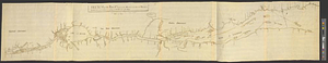
64.
Sketch of the seven dangerous rappids with their true channel : also the appearance the river makes at those places between...
65.
The St. Lawrence River between Trois Rivières and Grondines Parish
66.
The St. Lawrence River from the Rapids of Richelieu to Cape Torment
67.
St. Paul's Bay; Isle de Coudres; Great Cove; Pt. de Mille Vaches
68.
Town of Three Rivers
69.
United States of America : The course of the River St. Laurence, from Lake Ontario, to Manicougan Point
70.
An accurate map of North America
71.
America settle
72.
Amerikanisch-Spanischer kriegsschauplatz
73.
Amerique Septentrionale
74.
Amérique Septentrionale
75.
L'Amérique Septentrionale
76.
Amérique Septentrionale divisée en ses principaux etats
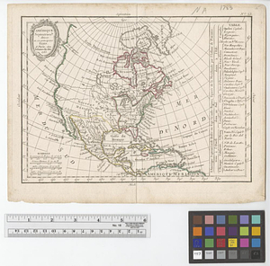
77.
Amérique Septentrionale publiée sous les auspices de Monseigneur le Duc d'Orleans prémier prince du sang
78.
The British colonies in North America
79.
British possessions in North America
80.
Carta universal en que se contiene todo lo que del mundo se ha descubierto fasta agora
81.
Carte de l'Amérique Septentrionale
82.
Carte de l'Amerique Septentrionale depuis le 28 degré de latitude jusqu'au 72
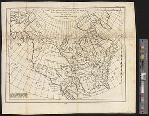
83.
Carte des parties nord et ouest de l'Amérique dressée d'apres les relations les plus authentique par M... en 1764 : nouvelle...
84.
Carte du Mexique et des pays limitrophes situés au nord et à l'est : dressée d'après la grande carte de la Nouvelle Espagne...
85.
Colton's map of the United States of America, the British provinces, Mexico and the West Indies : showing the country from the...
86.
Diagram of the United States of America, Mexico, the West India Islands and Isthmus of Darien : showing proposed routes of the...
87.
A General map of North America
88.
A general map of North America
89.
A general map of North America drawn from the best surveys 1795
90.
Illustrated Times map of North America
91.
Johnson's North America
92.
Karte von Nord-America für den schul- und privatgebrauch
93.
Linguistic families of American Indians north of Mexico
94.
A Map exhibiting the frontiers of Canada and the United States : intended to illustrate the operations of the British &...
95.
Map of North America : to illustrate facts of geographical distribution
96.
Map of North America : reduced from map on scale of 1:5,000,000
97.
Map of North America
98.
Map of North America
99.
Map of North America : showing all routes to Alaska and Klondike country
100.
A map of North America and the West Indies
‹ Prev
Next ›
1
2
3
4
5