Toggle navigation
LMEC Home
Exhibitions
Georeferencing
Tools for Teachers
Collections
My Favorites
Sign Up / Log In
Search
Search the map portal
Map Collection
Map Collection
Map Sets
Search
Search
Search for
Search In
All Fields
Creator
Title
Subject
Place
Search All Digital Collections
Advanced Search
32 Results
My Search
Start Over
More Like
commonwealth:z603vm55d
Remove constraint More Like: commonwealth:z603vm55d
Filter your Search
Place
North and Central America
17
Atlantic Ocean
16
United States
6
North America
5
Baffin Bay
2
Canada
2
Greenland
2
Kentucky
2
more
Place
»
Topic
North Atlantic Ocean--Maps--Early works to 1800
17
Nautical charts--North Atlantic Ocean--Early works to 1800
5
Atlantic Coast (North America)--Maps--Early works to 1800
3
America--Discovery and Exploration--Maps--Early works to 1800
2
Atlantic Coast (South America)--Maps--Early works to 1800
2
Atlantic Ocean--Maps--Early works to 1800
2
Baffin Bay--Maps--Early works to 1800
2
Greenland--Maps--Early works to 1800
2
more
Topic
»
Date
Date range begin
–
Date range end
Current results range from
1650
to
1828
View distribution
Creator
Green, John, -1757
2
Jefferys, Thomas, -1771
2
Sayer, Robert, 1725-1794
2
Andrews, Peter, active 1765-1782
1
Baldwin, Richard, 1724-1770
1
Bellin, Jacques Nicolas, 1703-1772
1
Bowen, Emanuel, d. 1767
1
Conder, Thomas, 1746 or 7-1831
1
more
Creator
»
Format
Maps/Atlases
32
Georeferenced
Yes
1
No
31
Collection
American Revolutionary War-Era Maps
22
Massachusetts Historical Society Map Collection
14
Norman B. Leventhal Map Center Collection
14
Maritime Charts and Atlases
5
Richard H. Brown Revolutionary War Map Collection at Mount Vernon
2
Boston Athenaeum, Cartographic Collection
1
Sidney R. Knafel Map Collection at Phillips Academy
1
Available to use
Creative Commons license
16
No known restrictions
14
Search Constraints
Sort by date (asc)
relevance
title
date (asc)
date (desc)
Number of results to display per page
20 per page
10
per page
20
per page
50
per page
100
per page
View results as:
grid view
map view
Search Results
1.
Mar del nort
2.
Pascaerte van Brazil en Nieu Nederlandt, van Corvo en Flores tot de Barbados
3.
Pascaerte vande Vlaemsche, Soute, en Caribesche Eylanden, als mede Terra Nova, en de custen van Nova Francia, Nova Anglia, Nieu...
4.
Pascaert van Nieu Nederland van Hendrick Christiaens Eijland tot staten hoeck of Cabo Cod
5.
Pascaarte vande Noorder Zee custen van America, vande West-hoeck van Ysland doorde Straet Davis en Hudson, tot aen Terra Neuf
6.
Terra nova, ac maris tractus circa Novam Franciam, Angliam, Belgium, Venezuelam Novam, Andalusiam, Guianan, et Brasiliam =...
7.
Archipelagus Atlanticus cum suis insulis Canariis, Hesperidibus et Azoribus
8.
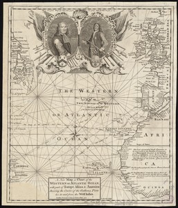
A new map or chart of the Western or Atlantic Ocean, with part of Europe Africa & America : showing the course of galleons,...
9.
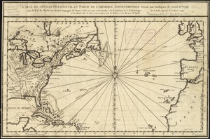
Carte de l'ocean occidental et partie de l'Amerique septentrionale : dressée pour l'intelligence du Journal du voyage que le...
10.
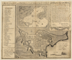
Plan of the city and fortress of Louisbourg
11.
A map of Pensilvania, New-Jersey, New-York, and the three Delaware counties
12.
Chart comprizing Greenland with the countries and islands about Baffin's and Hudson's Bays
13.
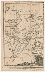
Map of the western parts of the colony of Virginia
14.
This plan of Kennebeck & Sagadahock Rivers & country adjacent
15.
Carte de l'Amérique septentrionale, 1754
16.
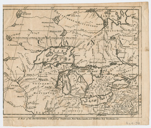
A Map of the five Great Lakes with part of Pensilvania, New York, Canada, and Hudsons Bay Territories &c
17.
An actual survey of the sea coast from New York to the I. Cape Briton : with tables of the direct and thwart courses &...
18.
A chart of the Atlantic Ocean : its islands and the adjacent continents: In which the British Dominions in Europe and America,...
19.
Chart comprizing Greenland with the countries and islands about Baffin's and Hudson's Bays
20.
A map of that part of America where a degree of latitude was measured for the Royal Society
‹ Prev
Next ›
1
2