An actual survey of the sea coast from New York to the I. Cape Briton : with tables of the direct and thwart courses & distances from place to place
This map is also available in American Revolutionary Geographies Online (ARGO), a collections portal especially built for material relating to the American Revolutionary War Era. Visit ARGO to learn more about this item and explore the historical geography of North America in the late eighteenth century.
Item Information
- Title:
- An actual survey of the sea coast from New York to the I. Cape Briton : with tables of the direct and thwart courses & distances from place to place
- Description:
-
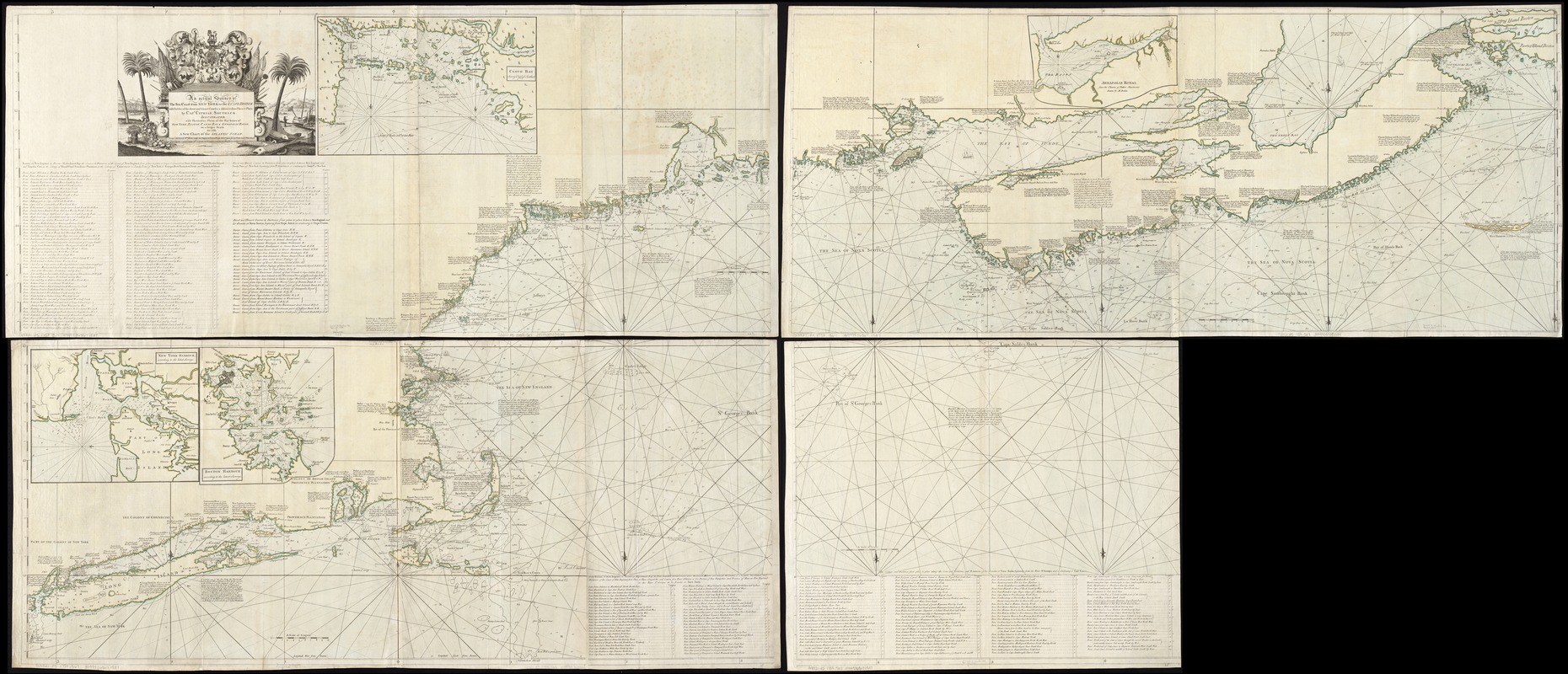
Cyprian Southack first published this enormous chart in book form between 1729 and 1734 as The New England Coasting Pilot. This is a later version, with additions including inset charts of Boston Bay, Casco Bay, and New York Harbor. The chart bears many autobiographical notes, such as Southack's 1717 voyage to Wellfleet to salvage the wreck of the pirate ship Whydah. A contemporary writer dismissed the chart as "one continued error, and … of pernicious consequence in trade and navigation." Yet it remains a monument of colonial mapmaking, being vastly more informative than any earlier effort to map New England's coast.
- Creator:
- Southack, Cyprian, 1662-1745
- Name on Item:
-
by Capt. Cyprian Southack.
- Date:
-
[1758?]
- Format:
-
Maps/Atlases
- Location:
-
Boston Public Library
Norman B. Leventhal Map & Education Center - Collection (local):
-
Norman B. Leventhal Map & Education Center Collection
- Subjects:
-
Nautical charts--Atlantic Coast (North America)--Early works to 1800
Coasts--New England--Maps--Early works to 1800
Coasts--Maritime Provinces--Maps--Early works to 1800
Nautical charts--New York Harbor (N.Y. and N.J.)--Early works to 1800
Atlantic Coast (North America)--Maps--Early works to 1800
North Atlantic Ocean--Maps--Early works to 1800
- Places:
-
North America (area)
New England (area)
Atlantic Ocean
- Extent:
- 1 map on 4 sheets : hand col. ; 105 x 248 cm., sheets 108 x 64 cm. or smaller.
- Terms of Use:
-
No known copyright restrictions.
No known restrictions on use.
- Publisher:
-
[London] :
Printed and sold by Wm. Herbert under the Piazzas on London Bridge & Robt. Sayer facing Fetter Lane, Fleet Street
- Scale:
-
Scale [ca. 1:585,000].
- Language:
-
English
- Notes:
-
Depths shown by soundings.
Shows longitude east and west from Boston.
"Illustrated with particular plans of the harbours of New York, Boston, Canso [i.e. Casco] Bay & Annopolis [sic] Royal, on a larger scale, as also, a new chart of the Atlantic Ocean."
Includes distance charts, notes, decorative cartouche, and insets of New York and Boston harbors, Casco Bay, Annapolis Royal, and the Atlantic Ocean from the equator to N 60⁰.
Cataloging, conservation, and digitization made possible in part by The National Endowment for the Humanities: Exploring the human endeavor.
- Notes (exhibitions):
-
Exhibited: "Made in Boston" organized by the Norman B. Leventhal Map Center at the Boston Public Library, 2013-2014.
- Identifier:
-
06_01_007197
- Call #:
-
G3321.P5 1758 .S67
- Barcode:
-
39999065671537


