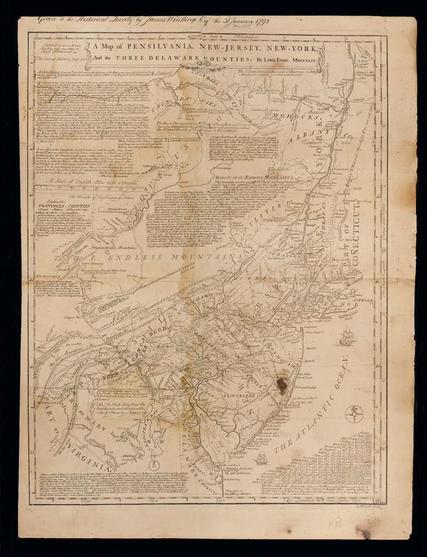
A map of Pensilvania, New-Jersey, New-York, and the three Delaware counties
This map is also available in American Revolutionary Geographies Online (ARGO), a collections portal especially built for material relating to the American Revolutionary War Era. Visit ARGO to learn more about this item and explore the historical geography of North America in the late eighteenth century.
Item Information
- Title:
- A map of Pensilvania, New-Jersey, New-York, and the three Delaware counties
- Creator:
- Evans, Lewis, 1700?-1756
- Contributor:
- Hebert, L.
- Name on Item:
-
by Lewis Evans ; L. Hebert, sculpt.
- Date:
-
[1752]
- Format:
-
Maps/Atlases
- Location:
- Massachusetts Historical Society
- Collection (local):
-
Massachusetts Historical Society Collection
- Subjects:
-
Middle Atlantic States--Maps--Early works to 1800
- Places:
-
Middle Atlantic (area)
- Extent:
- 1 map ; 65 x 49 cm on sheet 71 x 56 cm.
- Terms of Use:
-
No known copyright restrictions.
This work is licensed for use under a Creative Commons Attribution Non-Commercial Share Alike License (CC BY-NC-SA).

- Publisher:
-
Philadelphia :
[s.n.]
- Edition:
- 2d ed. July 1752
- Scale:
-
Scale ca. 1:960,000
- Language:
-
English
- Catalog Record:
-
http://balthazaar.masshist.org/cgi-bin/Pwebrecon.cgi?DB=local&BBID=159902
- Notes:
-
Relief shown pictorially. Soundings shown in fathoms.
Prime meridian: Philadelphia and London.
Shows trails.
Includes descriptive notes and distance chart.
- Notes (date):
-
This date is inferred.
- LCCN:
-
74691942


