Toggle navigation
LMEC Home
Exhibitions
Georeferencing
Tools for Teachers
Collections
My Favorites
Sign Up / Log In
Search
Search the map portal
Map Collection
Map Collection
Map Sets
Search
Search
Search for
Search In
All Fields
Creator
Title
Subject
Place
Search All Digital Collections
Advanced Search
639 Results
My Search
Start Over
More Like
commonwealth:z603vh006
Remove constraint More Like: commonwealth:z603vh006
Filter your Search
Place
North and Central America
597
United States
443
Canada
151
Quebec
73
New York
60
North America
32
Saint Lawrence River
27
West Indies
23
more
Place
»
Topic
United States--Maps
330
United States--History--French and Indian War, 1754-1763--Maps
162
Canada--Maps
55
Elections--United States--Maps
36
Railroads--United States--Maps
34
North America--Maps
30
Saint Lawrence River--Maps
27
West Indies--Maps
24
more
Topic
»
Date
Date range begin
–
Date range end
Current results range from
1750
to
2023
View distribution
Creator
Paullin, Charles Oscar, 1868 or 1869-1944
70
Wright, John Kirtland, 1891-1969
70
Rocque, Mary Ann
24
Jefferys, Thomas, -1771
18
Geological Survey (U.S.)
15
Orme, Robert, -1781
14
Reid, John, 1764?-1828
11
Bellin, Jacques Nicolas, 1703-1772
10
more
Creator
»
Format
Maps/Atlases
636
Manuscripts
13
Prints
3
Books
1
Objects/Artifacts
1
Posters
1
Georeferenced
Yes
77
No
562
Collection
American Revolutionary War-Era Maps
325
Norman B. Leventhal Map & Education Center Collection
317
William L. Clements Library Collection
167
American Antiquarian Society Collection
138
MacLean Collection Map Library
11
Richard H. Brown Revolutionary War Map Collection at Mount Vernon
4
Boston and New England Maps
3
David Judkins Weaver Papers
2
more
Collection
»
Available to use
No known restrictions
243
Creative Commons license
10
Search Constraints
Sort by relevance
relevance
title
date (asc)
date (desc)
Number of results to display per page
20 per page
10
per page
20
per page
50
per page
100
per page
View results as:
grid view
map view
Search Results
341.
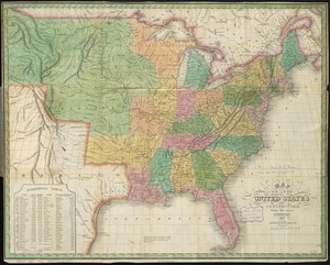
Map of the United States, constructed from the latest authorities
342.
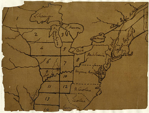
A map of the United States east of the Mississippi River in which the land ceded by the Treaty of Paris is divided by parallels...
343.
A map of the United States east of the Mississippi River in which the land ceded by the Treaty of Paris is divided by parallels...
344.
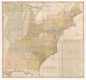
Map of the United States, exhibiting the post-roads, the situations, connections & distances of the post-offices stage roads,...
345.
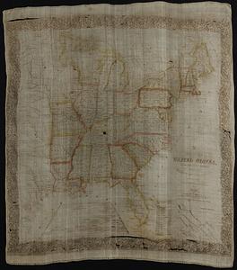
Map of the United States exhibiting the several collection districts
346.
Map of the United States, from the latest surveys : with the heights of mountains and length of the principle rivers
347.
A map of the United States, from the latest surveys : with the height of mountains and length of the principal rivers
348.
Map of the United States including Oregon, Texas and the Californias
349.
Map of the United States of America
350.
Map of the United States of America
351.
Map of the United States of America : including Canada and a large portion of Texas showing the base meridian and township...
352.
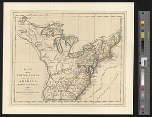
A map of the United States of America as settled by the peace of 1783
353.
Map of the United States of America, Mexico, Central America, and the West India Islands
354.
Map of the United States of America, the British Provinces, Mexico, the West Indies and Central America, with part of New...
355.
Map of the United States of America, the British provinces, Mexico, the West Indies and Central America, with part of New...
356.
Map of the United States of North America
357.
A map of the United States of North America : drawn from a number of critical researches
358.
Map of the United States of North America, upper & lower Canada, New Brunswick, Nova Scotia & British Columbia, Mexico, Cuba,...
359.
Map of the United States, showing by colors the area of freedom and slavery, and the territories whose destiny is yet to be...
360.
Map of the United States showing principal cities, rivers, and mountain ranges
‹ Prev
Next ›
1
2
…
14
15
16
17
18
19
20
21
22
…
31
32