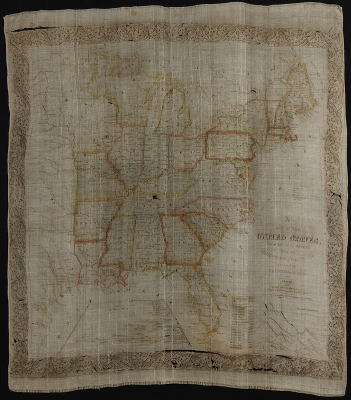
A map of the United States, from the latest surveys : with the height of mountains and length of the principal rivers
Item Information
- Title:
- A map of the United States, from the latest surveys : with the height of mountains and length of the principal rivers
- Engraver:
- Boynton, George W., -1884
- Printer:
- Tremont Print Company
- Publisher:
- Tuttle, Joseph Willard, 1813-1888
- Date:
-
[1841]
- Format:
-
Maps/Atlases
- Location:
-
Boston Public Library
Norman B. Leventhal Map & Education Center - Collection (local):
-
Norman B. Leventhal Map & Education Center Collection
- Subjects:
-
United States--Maps
Mountains--United States--Charts, diagrams, etc
Rivers--United States--Charts, diagrams, etc
- Places:
-
United States
- Extent:
- 1 map : color, on linen ; 58 x 56 cm, on sheet 74 x 65 cm
- Terms of Use:
-
No known copyright restrictions.
No known restrictions on use.
- Publisher:
-
Boston, Mass. :
Joseph W. Tuttle Company
- Scale:
-
Scale 1:4,800,000
- Language:
-
English
- Notes:
-
Prime meridian: [Washington, D.C.].
Cloth map intended for use as a pocket handkerchief.
Insets: Length of the principal rivers -- Principal mountains.
"Patent. Printed and published by Joseph W. Tuttle, Boston, Mass. Engraved by G.W. Boynton 109 Washington Street, Boston."
"Entered according to Act of Congress in the year 1841 by the Tremont Print Company in the Clerk's Office of the District Court of Massachusetts."
- Notes (date):
-
This date is inferred.
- Notes (citation):
-
Collins. H. Threads of History, 152, 153
- Identifier:
-
06_01_018947
- Call #:
-
G3700 1841 .B692
- Barcode:
-
39999085970646


