Toggle navigation
LMEC Home
Exhibitions
Georeferencing
Tools for Teachers
Collections
My Favorites
Sign Up / Log In
Search
Search the map portal
Map Collection
Map Collection
Map Sets
Search
Search
Search for
Search In
All Fields
Creator
Title
Subject
Place
Search All Digital Collections
Advanced Search
8702 Results
My Search
Start Over
More Like
commonwealth:xg94j274b
Remove constraint More Like: commonwealth:xg94j274b
Filter your Search
Place
North and Central America
5,933
United States
4,851
Massachusetts
2,083
Europe
1,396
Suffolk (county)
1,046
Boston
1,019
Canada
449
Asia
438
more
Place
»
Topic
Boston (Mass.)--Maps
586
United States--Maps
282
Real property--Massachusetts--Boston--Maps
175
Massachusetts--Maps
162
Landowners--Massachusetts--Boston--Maps
133
North America--Maps--Early works to 1800
103
New England--Maps
102
Europe--Maps
79
more
Topic
»
Date
Date range begin
–
Date range end
Current results range from
1482
to
2023
View distribution
Creator
United States. Hydrographic Office
595
O.H. Bailey & Co
148
Des Barres, Joseph F. W. (Joseph Frederick Wallet), 1722-1824
123
United States. Post Office Dept
120
Ptolemy, 2nd cent
100
Walling, Henry Francis, 1825-1888
94
Geological Survey (U.S.)
86
Jefferys, Thomas, -1771
85
more
Creator
»
Format
Maps/Atlases
8,642
Manuscripts
215
Prints
56
Books
36
Objects/Artifacts
10
Drawings/Illustrations
8
Posters
5
Georeferenced
Yes
869
No
7,833
Collection
Norman B. Leventhal Map & Education Center Collection
8,698
Boston and New England Maps
2,236
Urban Maps
2,023
Maritime Charts and Atlases
1,083
American Revolutionary War-Era Maps
617
Boston Redevelopment Authority Collection
87
David Judkins Weaver Papers
4
Massachusetts Real Estate Atlases
3
more
Collection
»
Available to use
No known restrictions
8,556
Creative Commons license
47
Search Constraints
Sort by relevance
relevance
title
date (asc)
date (desc)
Number of results to display per page
20 per page
10
per page
20
per page
50
per page
100
per page
View results as:
grid view
map view
Search Results
21.
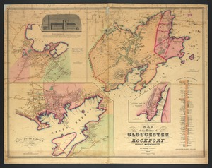
Map of the towns of Gloucester and Rockport, Essex Co., Massachusetts
22.
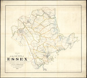
Plan of the county of Essex : compiled from the original furnished by the state and corrected under the direction of James...
23.
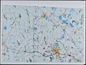
A topographical map of Essex County, Massachusetts : based upon the trigonometrical survey of the state
24.
Atlas of Worcester County, Massachusetts
25.
Land use in northern Worcester County, Mass. ; open spaces and protected areas in the northern Worcester County, Mass.
26.
Atlas of the North Shore, Beverly to Magnolia, Essex Co., Massachusetts
27.
Atlas of the towns of Topsfield, Ipswich, Essex, Hamilton and Wenham, Essex County, Massachusetts
28.
The county of Essex, Massachusetts
29.
Land use shading test plot shadeset PI and lu21-pi.lut
30.
Northeast Massachusetts
31.
Part of modern Rockingham County (N.H.) and Essex County (Mass.)
32.
The 100th anniversary map of Abraham Lincoln's visit to Massachusetts, September 11-23, 1848
33.
1630 shoreline
34.
1879. Progress map of the U.S. Geographical Surveys west of the 100th Meridian : prepared under the direction of 1st Lieut....
35.
1903 Map of Salem and surrounding places
36.
19th annual convention of the National Association of Real Estate Boards : at Tulsa, June 7 to June 11 in 1926
37.
2005 significant U.S. hurricane strikes
38.
The 2100 project : an atlas for the Green New Deal
39.
227 Harzgerode
40.
305 Glatz
‹ Prev
Next ›
1
2
3
4
5
6
…
435
436