Toggle navigation
LMEC Home
Exhibitions
Georeferencing
Tools for Teachers
Collections
My Favorites
Sign Up / Log In
Search
Search the map portal
Map Collection
Map Collection
Map Sets
Search
Search
Search for
Search In
All Fields
Creator
Title
Subject
Place
Search All Digital Collections
Advanced Search
566 Results
My Search
Start Over
More Like
commonwealth:x346kq30c
Remove constraint More Like: commonwealth:x346kq30c
Filter your Search
Place
North and Central America
462
United States
243
North America
237
Canada
76
New York
26
Asia
19
Pennsylvania
18
Great Lakes Region
15
more
Place
»
Topic
North America--Maps--Early works to 1800
240
United States--Maps--Early works to 1800
57
Canada--Maps--Early works to 1800
50
Great Britain--Colonies--America--Maps--Early works to 1800
22
Great Lakes Region (North America)--Maps--Early works to 1800
14
Northeastern States--Maps--Early works to 1800
12
New England--Maps--Early works to 1800
11
Pennsylvania--Maps--Early works to 1800
11
more
Topic
»
Date
Date range begin
–
Date range end
Current results range from
1528
to
1999
View distribution
Creator
Jefferys, Thomas, -1771
29
Mitchell, John, 1711-1768
22
Sayer, Robert, 1725-1794
20
Gibson, J. (John), active 1750-1792
19
Bellin, Jacques Nicolas, 1703-1772
17
Anville, Jean Baptiste Bourguignon d', 1697-1782
16
Robert Sayer and John Bennett (Firm)
16
Faden, William, 1749-1836
14
more
Creator
»
Format
Maps/Atlases
564
Manuscripts
5
Paintings
3
Ephemera
1
Objects/Artifacts
1
Prints
1
Georeferenced
Yes
4
No
562
Collection
American Revolutionary War-Era Maps
451
MacLean Collection Map Library
379
Norman B. Leventhal Map & Education Center Collection
116
New York Public Library Collection
34
Richard H. Brown Revolutionary War Map Collection at Mount Vernon
18
Mapping Boston Collection
10
Sidney R. Knafel Map Collection at Phillips Academy
8
British Library Collection
3
more
Collection
»
Available to use
No known restrictions
110
Creative Commons license
66
Search Constraints
Sort by relevance
relevance
title
date (asc)
date (desc)
Number of results to display per page
20 per page
10
per page
20
per page
50
per page
100
per page
View results as:
grid view
map view
Search Results
501.
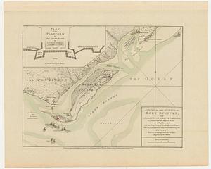
A plan of the attack of Fort Sulivan, near Charles Town in South Carolina, by a squadron of His Majesty's ships, on the 28.th...
502.
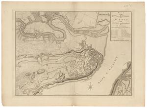
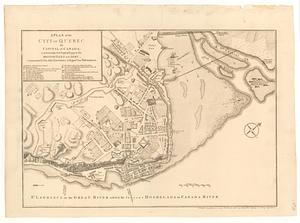
Plan of the city and environs of Quebec, with its siege and blockade by the Americans, from the 8.th of December 1775 to the...
503.
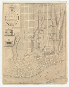
A plan of the city of Albany surveyed at the request of the Mayor Aldermen and commonalty
504.
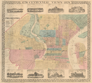
Plan of the city of Philadelphia
505.
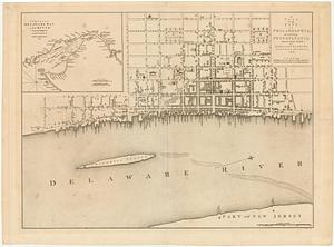
A plan of the city of Philadelphia, the capital of Pennsylvania, from an actual survey
506.
A plan of the city of Quebec the capital of Canada : as it surrender'd 18 Septemb.r 1759 to the British fleet and army ;...
507.
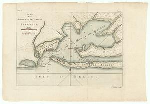
Plan of the harbour and settlement of Pensacola
508.
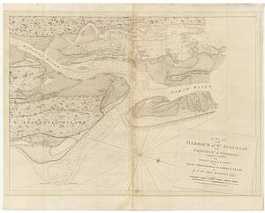
A plan of the harbour of S.t Augustin in the province of Georgia
509.
A plan of the island of S.t John with the divisions of the counties parishes & the lots as granted by government likewise the...
510.
Plan of the mil.y reservation at Detroit
511.
A plan of the posts of York and Gloucester in the province of Virginia, established by His Majesty's army under the command of...
512.
A plan of the town, bar, harbour and environs, of Charlestown in South Carolina, with all the channels, soundings,...
513.
Plan of the town of Erie on Lake Erie
514.
Plan of the town of Stratham
515.
A plan of the west line or parallel of latitude : which is the boundary between the provinces of Maryland and Pensylvania
516.
Plan stolichnogo goroda Moskvy i yego okrestnostey s oboznacheniyem basseynov, telegrafnykh stantsiy i soyedinyayushchikh...
517.
Plan von Berlin mit nächster umgebung
518.
Plano de Manila y sus arrabales 1894
519.
Plano general de la ciudad de Mexico
520.
Proposals of Osgood Carleton and John Norman, for publishing by subscription, an accurate map of the commonwealth of...
‹ Prev
Next ›
1
2
…
22
23
24
25
26
27
28
29