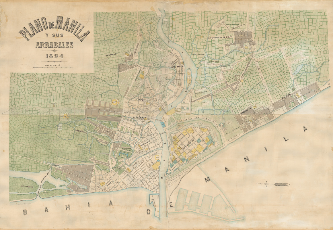
Plano de Manila y sus arrabales 1894
Item Information
- Title:
- Plano de Manila y sus arrabales 1894
- Description:
-
Manila became an important port after the 1570s, when the Spanish established their base of maritime trade in the Asia there, having already established trade bases on the Americas side of the Pacific in Acapulco and Lima. The Spanish trade system primarily exported silver from the Americas to Manila in exchange for East Asian finished goods like porcelain and lacquer as well finished and unfinished silk products. On this map, Manila is oriented with east toward the top of the map following the Rio Pasig that divides the city north and south as it comes from Manila Bay (Bahia de Manila). The Intramuros ward is clearly labeled. Established by the Spanish in the late sixteenth century the walled fortification with protective bastions still stands today. The many churches and cathedrals inside the Intramuros are demarcated in yellow. Across the river are the Tondo and Binando sections of the city where trade occured and Chinese and Japanese communities stood from the sixteen to nineteenth centuries. Green rice patty fields, today all part of the urban sprawl of Manila, surrounded the city at that time. A series of maps of the city were made in 1890s, the best known was by Francisco J. de Gamoneda in 1898. Although the general presentation is the same here, those maps were on a scale of 1:10,000 while this version is larger and on a scale of 1:5,000.
- Date:
-
1894
- Format:
-
Maps/Atlases
- Location:
- MacLean Collection Map Library
- Collection (local):
-
MacLean Collection Map Library
- Subjects:
-
Manila (Philippines)--Maps
- Places:
-
Manila
- Extent:
- 1 map : color ; 102 cm x 142 cm
- Terms of Use:
-
Public Domain/No known restrictions on use. Contact host institution to download image.
Contact host institution for more information.
- Publisher:
-
Manila :
Lit De Chofre y Co.
- Scale:
-
Scale [1:5,000]
- Language:
-
Spanish
- Notes:
-
Shows the city plan of old Manila, featuring the house areas, infrastructures and country fields.
Oriented with north to the left.
Copper plate engraving.
- Identifier:
-
MacLeanColl_34822_Manila
- Call #:
-
34822