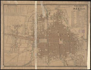
Plano general de la ciudad de Mexico
This map is also available in American Revolutionary Geographies Online (ARGO), a collections portal especially built for material relating to the American Revolutionary War Era. Visit ARGO to learn more about this item and explore the historical geography of North America in the late eighteenth century.
Item Information
- Title:
- Plano general de la ciudad de Mexico
- Description:
-
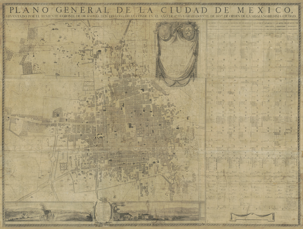
The original surveys for this plan of Mexico City were conducted in 1793, during the vice-regal administration of Conde de Revillagigedo. His administration, one of the most progressive of the colonial era, resulted in urban development and renewal that included the construction and the renovation of numerous public buildings and parks; improved sanitation, lighting, and security; the construction of roads and streets; and the establishment of professional schools, like the Royal Academy of San Carlos, where this map was produced. The city is divided into eight quarters, which are organized alphabetically by street name in the extensive key to the right of the map which coordinates with the labels found throughout the plan. Along the bottom are two panoramic views of the city from the east, on the new road toward Vera Cruz and from the west, on the road to Chapultepec. The mapmaker was Diego García Conde (1760-1822), a native of Barcelona who came to Mexico and served as captain of the Spanish Dragoons in Mexico. Conde supervised several complex construction projects, including the road from Vera Cruz to Jalapa. In 1822 he was named director general of the Corps of Engineers and founded the Academy of Cadets. The plan’s engraver was José Joaquín Fabregat (1748-1807), a native of Valencia, who in 1787, was named Director of Engraving at the Royal Academy of San Carlos.
- Cartographer:
- García Conde, Diego
- Name on Item:
-
levantado por el Teniente Coronel de Dragones Don Diego Garcia Conde en el ano de 1793, y grabado en el ano de 1807, de orden de la misma nobilisima ciudad
- Date:
-
1807
- Format:
-
Maps/Atlases
- Location:
- MacLean Collection Map Library
- Collection (local):
-
MacLean Collection Map Library
- Subjects:
-
Mexico City (Mexico)--Maps
- Places:
-
Distrito Federal (territory)Mexico City
- Extent:
- 1 map ; 148 cm x 198 cm
- Terms of Use:
-
Public Domain/No known restrictions on use. Contact host institution to download image.
Contact host institution for more information.
- Place of origin:
-
[Mexico City]
- Scale:
-
Scale [ca. 1:3,300]
- Language:
-
Spanish
- Notes:
-
Extremely rare, first and only printing in large format of the most important early plan of Mexico City. The plates for this map were destroyed and lost, but the map was republished in much smaller format in London in 1811 and in New York in 1830.
The original surveys for this plan of Mexico City were conducted in 1793 during the viceragal administration of Conde de Revillagigedo.
Copper plate engraving.
- Notes (citation):
-
Dicc. Porrua, p. 1156
- Identifier:
-
MacLeanColl_21144_MexicoCity
- Call #:
-
21144