Toggle navigation
LMEC Home
Exhibitions
Georeferencing
Tools for Teachers
Collections
My Favorites
Sign Up / Log In
Search
Search the map portal
Map Collection
Map Collection
Map Sets
Search
Search
Search for
Search In
All Fields
Creator
Title
Subject
Place
Search All Digital Collections
Advanced Search
8939 Results
My Search
Start Over
More Like
commonwealth:wd376704k
Remove constraint More Like: commonwealth:wd376704k
Filter your Search
Place
North and Central America
6,170
United States
5,074
Massachusetts
2,209
Europe
1,396
Suffolk (county)
1,215
Boston
1,188
Canada
450
Asia
438
more
Place
»
Topic
Boston (Mass.)--Maps
752
United States--Maps
282
Massachusetts--Maps
235
Real property--Massachusetts--Boston--Maps
195
City planning--Massachusetts--Boston--Maps
162
Landowners--Massachusetts--Boston--Maps
142
New England--Maps
106
North America--Maps--Early works to 1800
103
more
Topic
»
Date
Date range begin
–
Date range end
Current results range from
1482
to
2023
View distribution
Creator
United States. Hydrographic Office
595
Boston Redevelopment Authority
168
O.H. Bailey & Co
148
Des Barres, Joseph F. W. (Joseph Frederick Wallet), 1722-1824
124
United States. Post Office Dept
120
Ptolemy, 2nd cent
100
Walling, Henry Francis, 1825-1888
95
Geological Survey (U.S.)
92
more
Creator
»
Format
Maps/Atlases
8,878
Manuscripts
217
Prints
56
Books
36
Objects/Artifacts
10
Drawings/Illustrations
8
Posters
5
Ephemera
1
Georeferenced
Yes
894
No
8,045
Collection
Norman B. Leventhal Map & Education Center Collection
8,766
Boston and New England Maps
2,410
Urban Maps
2,148
Maritime Charts and Atlases
1,083
American Revolutionary War-Era Maps
657
Boston Redevelopment Authority Collection
200
David Judkins Weaver Papers
22
Mapping Boston Collection
22
more
Collection
»
Available to use
No known restrictions
8,714
Creative Commons license
73
Search Constraints
Sort by relevance
relevance
title
date (asc)
date (desc)
Number of results to display per page
20 per page
10
per page
20
per page
50
per page
100
per page
View results as:
grid view
map view
Search Results
7721.
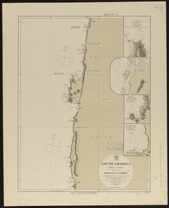
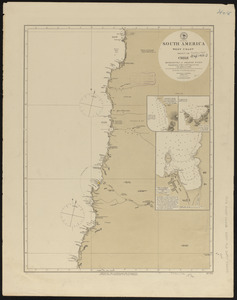
South America, west coast : republication of Brit. Admty. chart no. 1277, with additions to 1876
7722.
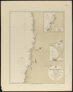
South America, west coast : republication of Brit. Admty. chart no. 1287, with additions to 1876
7723.
South America, west coast : republication of Brit. Admty. chart no. 1286, with additions to 1876
7724.
South America, west coast : republication of Brit. Admty. chart no. 1325, with additions to 1876
7725.
South America, west coast : republication of Brit. Admiralty chart no. 1289, with additions to 1876
7726.
South America, west coast : republication of Brit. Admty. chart no. 1276, with additions to 1876
7727.
South America, west coast : republication of Brit. Admty. chart no. 1282, with additions to 1876
7728.
South America, west coast : republication of Brit. Admty. chart no. 1285, with additions to 1877
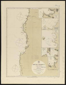
7729.
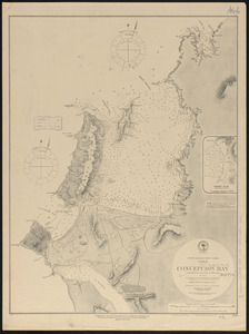
South America-- west coast, Chile, Concepcion Bay : from British and French surveys
7730.
South America, west coast, Chile, Coronel, Lota & Colcura anchorages in Arauco Bay : from a Chilean government survey in 1878
7731.
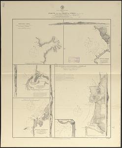
South America, west coast, Chile, ports on the coast of Chile : special plans to chart no. 753 : from surveys by Capt. Pomar...
7732.
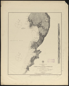
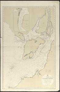
South America, west coast, Ecuador, Guayaquil River : from a British survey in 1847, corrected to 1876 ; republication of Brit....
7733.
South America, west coast, harbors on the coast of Ecuador : from British surveys in 1837 and 1847 ; republication of Brit....
7734.
South America, west coast, harbors on the coast of New Granada : special plans to chart no. 766
7735.
South America, west coast, Nueva Granada, Port Buenaventura : from a British survey in 1846 ; republication of Brit. Admty....
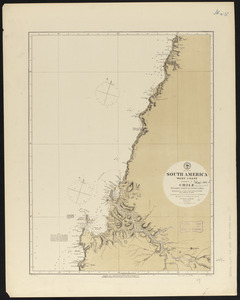
7736.
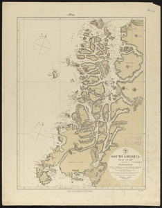
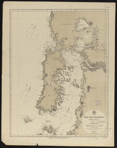
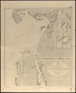
South America, west coast of Patagonia, channels between Magellan Strait and the Gulf of Trinidad : compiled from the most...
7737.
South America, west coast of Patagonia, channels between the Gulfs of Trinidad and of Peñas : compiled from the most recent...
7738.
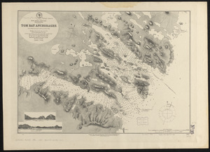
South America-- west coast, Patagonia, Tom Bay anchorages : from British surveys in 1879, corrected to 1882
7739.
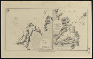
South America, west coast, Port Barbara : from a British survey corrected to 1877 ; South America, west coast, Port Otway in...
7740.
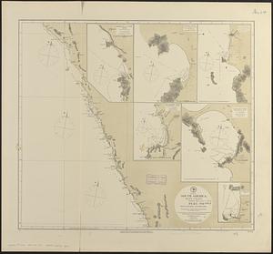
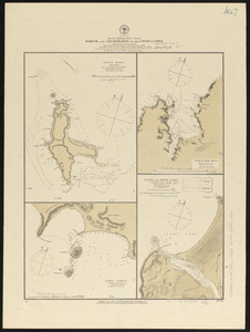
South America, west coast, ports and anchorages on the coast of Chile : special plans to chart no. 752, Santa Maria Id. &...
‹ Prev
Next ›
1
2
…
383
384
385
386
387
388
389
390
391
…
446
447