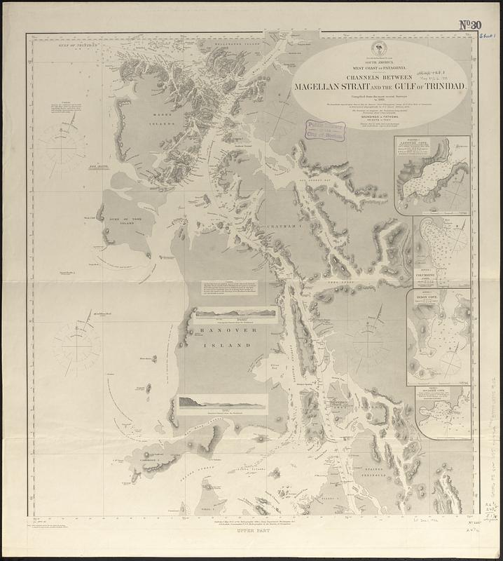
South America, west coast of Patagonia, channels between Magellan Strait and the Gulf of Trinidad : compiled from the most recent surveys to 1883
Viewing image 1 of 2
Carousel content with 0 slides.
A carousel is a rotating set of images, rotation stops on keyboard focus on carousel tab controls or hovering the mouse pointer over images. Use the tabs or the previous and next buttons to change the displayed slide.
Item Information
- Title:
- South America, west coast of Patagonia, channels between Magellan Strait and the Gulf of Trinidad : compiled from the most recent surveys to 1883
- Issuing body:
- United States. Hydrographic Office
- Date:
-
[1888]
- Format:
-
Maps/Atlases
- Genre:
-
Nautical charts
- Location:
-
Boston Public Library
Norman B. Leventhal Map & Education Center - Collection (local):
-
Norman B. Leventhal Map & Education Center Collection
- Subjects:
-
Magallanes y Antártica Chilena (Chile)--Maps
Madre de Dios Archipelago (Chile)--Maps
Reina Adelaida Archipelago (Chile)--Maps
Coasts--Chile--Maps
Nautical charts--Chile--Magallanes y Antártica Chilena
- Places:
-
ChileMagallanes y de la Antártica Chilena (region)
ChileMagallanes y de la Antártica Chilena (region)Madre de Dios, Archipiélago (island)
ChileMagallanes y de la Antártica Chilena (region)Reina Adelaida, Archipiélago (island)
- Extent:
- 1 map on 2 sheets ; 120 x 63 cm, on sheets 79 x 71 cm and 76 x 71 cm
- Terms of Use:
-
No known copyright restrictions.
No known restrictions on use.
- Publisher:
-
Washington, D.C. :
Hydrographic Office
- Scale:
-
Scale approximately 1:308,000
- Language:
-
English
- Table of Contents:
-
Upper part
Lower part
- Notes:
-
Relief shown by hachures and spot heights. Depths shown by soundings.
Includes 4 insets and 3 coastal views.
Insets: Hanover I., Latitude Cove -- Newton I., Columbine Cove -- Newton I., Dixon Cove -- Piazzi I., Occasion Cove.
"Cor. 1888.35"--Lower left corner of upper sheet.
"Cor. 1885.360.)(1886.6.21.39.)(1888-47."--Lower left corner of lower sheet.
- Notes (date):
-
This date is inferred.
- Identifier:
-
06_01_017405A
06_01_017405B
- Call #:
-
G9096.P5 svar .U55 nos.446 a-b
- Barcode:
-
39999085959102


