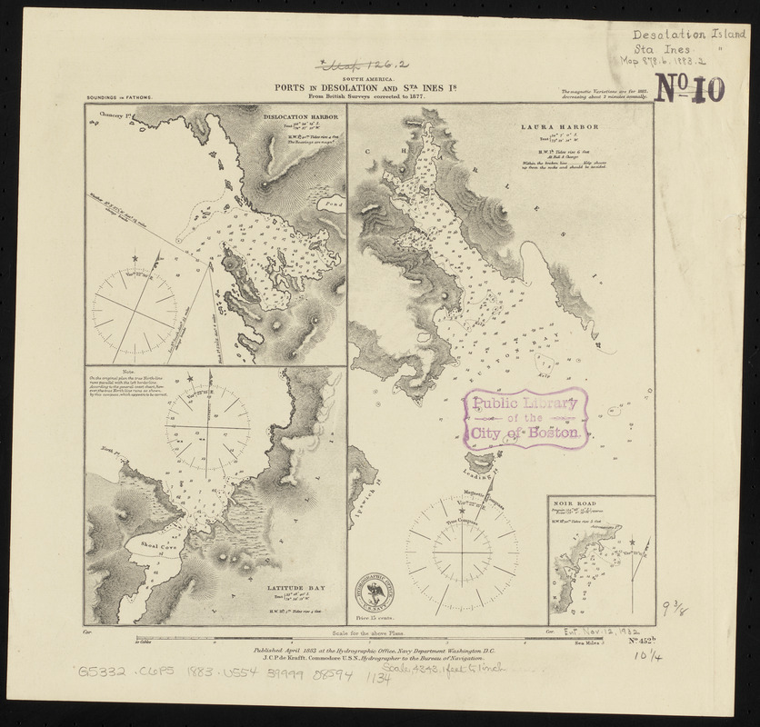
South America, ports in Desolation and Sta. Ines Is. : from British surveys corrected to 1877
Item Information
- Title:
- South America, ports in Desolation and Sta. Ines Is. : from British surveys corrected to 1877
- Title (alt.):
-
Ports of Desolation and Sta. Ines Is.
- Issuing body:
- United States. Hydrographic Office
- Date:
-
1883
- Format:
-
Maps/Atlases
- Location:
-
Boston Public Library
Norman B. Leventhal Map & Education Center - Collection (local):
-
Norman B. Leventhal Map & Education Center Collection
- Subjects:
-
Coasts--Chile--Maps
Nautical charts--Chile--Dislocación Bay
Nautical charts--Chile--Latitud Bay
Nautical charts--Chile--Laura Bay
Nautical charts--Chile--Noir Island
Dislocación Bay (Chile)--Maps
Latitud Bay (Chile)--Maps
Laura Bay (Chile)--Maps
Noir Island (Chile)--Maps
- Places:
-
ChileMagallanes y de la Antártica Chilena (region)Dislocación, Bahía (bay)
ChileMagallanes y de la Antártica Chilena (region)Latitud, Bahía (bay)
ChileMagallanes y de la Antártica Chilena (region)Laura, Seno (bay)
- Extent:
- 4 maps on 1 sheet ; 24 x 26 cm
- Terms of Use:
-
No known copyright restrictions.
No known restrictions on use.
- Publisher:
-
Washington, D.C. :
Hydrographic Office
- Scale:
-
Scale approximately 1:52,500
Scale approximately 1:52,500
Scale approximately 1:52,500
Scale approximately 1:52,500
- Language:
-
English
- Table of Contents:
-
Dislocation Harbor
Latitude Bay
Laura Harbor
Noir Road.
- Notes:
-
Relief shown by hachures. Depths shown by soundings.
- Identifier:
-
06_01_015888
- Call #:
-
G9096.P5 svar .U55
- Barcode:
-
39999085941134