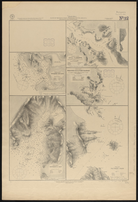
Plans on the west coast of Patagonia, South America : from the most recent British surveys
Item Information
- Title:
- Plans on the west coast of Patagonia, South America : from the most recent British surveys
- Issuing body:
- United States. Hydrographic Office
- Printer:
- Leggo Bros. & Co.
- Date:
-
1889
- Format:
-
Maps/Atlases
- Location:
-
Boston Public Library
Norman B. Leventhal Map & Education Center - Collection (local):
-
Norman B. Leventhal Map & Education Center Collection
- Subjects:
-
Coasts--Chile--Maps
Nautical charts--Chile--Bueno Harbor
Nautical charts--Chile--Guía Narrows
Nautical charts--Chile--Isthmus Bay
Nautical charts--Chile--Mardon Cove
Nautical charts--Chile--Victoria Pass
Bueno Harbor (Chile)--Maps
Guía Narrows (Chile)--Maps
Isthmus Bay (Chile)--Maps
Welcome Bay (Chile)--Maps
Mardon Cove (Chile)--Maps
Victoria Pass (Chile)--Maps
- Places:
-
ChileMagallanes y de la Antártica Chilena (region)Bueno, Puerto (harbor)
ChileMagallanes y de la Antártica Chilena (region)Guía, Angostura (narrow)
ChileMagallanes y de la Antártica Chilena (region)Isthmus, Bahía (bay)
ChileMagallanes y de la Antártica Chilena (region)Welcome, Bahía (bay)
ChileMagallanes y de la Antártica Chilena (region)Mardon, Puerto (cove)
ChileMagallanes y de la Antártica Chilena (region)Victoria, Paso (marine channel)
- Extent:
- 5 maps on 1 sheet ; 58 x 43 cm
- Terms of Use:
-
No known copyright restrictions.
No known restrictions on use.
- Publisher:
-
Washington, D.C. :
Hydrographic Office
- Edition:
- Edition of April 1889
- Scale:
-
Scales differ
- Language:
-
English
- Table of Contents:
-
Sarmiento Channel, Puerto Bueno
Smyth Channel, Isthmus Bay
Sarmiento Channel, Guia Narrows
Smyth Channel, Welcome Bay & Port Mardon
Union Sound, Victory Pass.
- Notes:
-
Relief shown by hachures and spot heights. Depths shown by soundings and isolines.
Includes view of Guia Narrows.
- Identifier:
-
06_01_015834
- Call #:
-
G9096.P5 svar .U55
- Barcode:
-
39999085940805