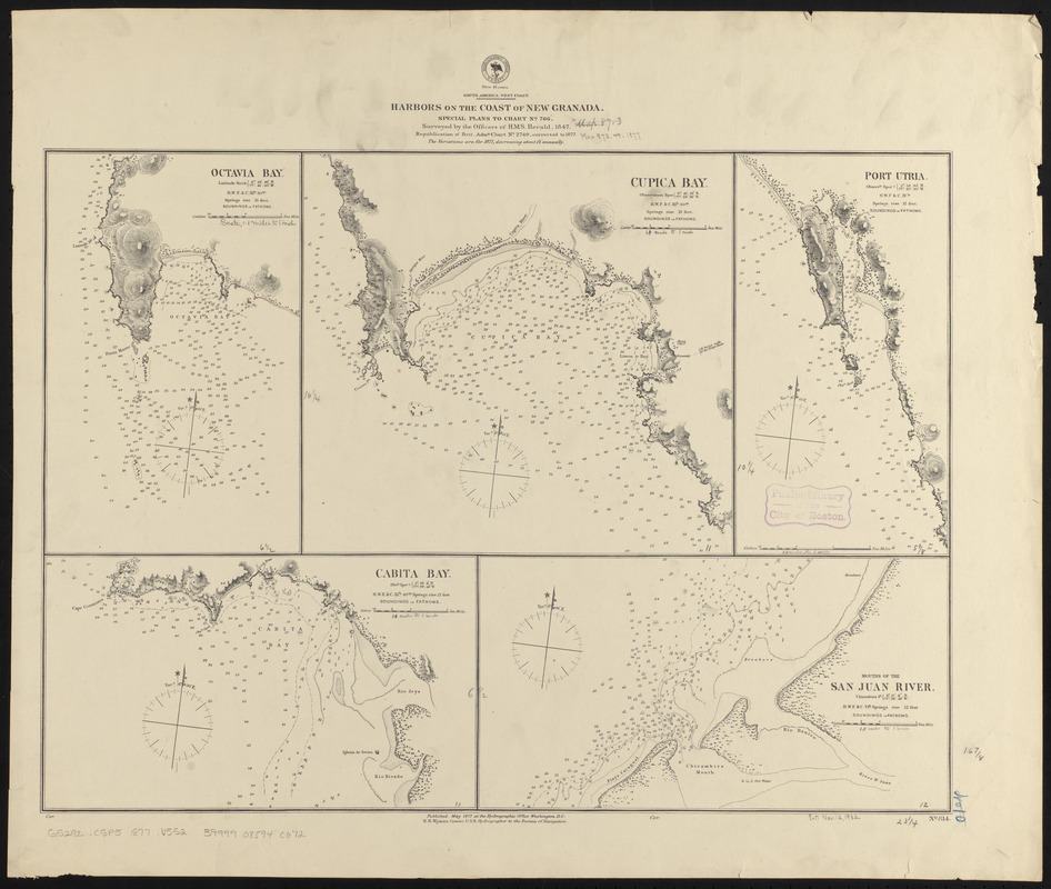
South America, west coast, harbors on the coast of New Granada : special plans to chart no. 766
Item Information
- Title:
- South America, west coast, harbors on the coast of New Granada : special plans to chart no. 766
- Title (alt.):
-
Harbors on the coast of New Granada
- Issuing body:
- United States. Hydrographic Office
- Name on Item:
-
surveyed by the officers of H.M.S. Herald, 1847 ; republication of Brit. Admty. chart no. 2749 corrected to 1877
- Date:
-
1877
- Format:
-
Maps/Atlases
- Location:
-
Boston Public Library
Norman B. Leventhal Map & Education Center - Collection (local):
-
Norman B. Leventhal Map & Education Center Collection
- Subjects:
-
Coasts--Colombia--Maps
Nautical charts--Colombia--Octavia Bay
Nautical charts--Colombia--Cupica Bay
Nautical charts--Colombia--Utria Cove
Nautical charts--Colombia--Cuevita Bay
Octavia Bay (Colombia)--Maps
Cupica Bay (Colombia)--Maps
Utria Cove (Colombia)--Maps
Cuevita Bay (Colombia)--Maps
Charambirá (Colombia)--Maps
- Places:
-
ColombiaChocóCupica, Golfo de (gulf)
Bahía Aguacate
Ensenada de Utría
Bahía Cuevita
Punta Charambirá
- Extent:
- 5 maps on 1 sheet ; 43 x 59 cm
- Terms of Use:
-
No known copyright restrictions.
No known restrictions on use.
- Publisher:
-
Washington, D.C. :
Hydrographic Office
- Scale:
-
Scales differ
- Language:
-
English
- Table of Contents:
-
Octavia Bay
Cupica Bay
Port Utria
Cabita Bay
Mouths of the San Juan River.
- Notes:
-
Relief shown by hachures and spot heights. Depths shown by soundings and isolines.
- Identifier:
-
06_01_015835
- Call #:
-
G9096.P5 svar .U55
- Barcode:
-
39999085940672