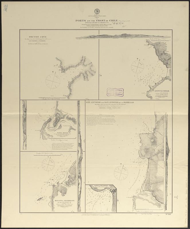
South America, west coast, Chile, ports on the coast of Chile : special plans to chart no. 753 : from surveys by Capt. Pomar and the officers of the Chilean steam corvette Ancud in 1875
Item Information
- Title:
- South America, west coast, Chile, ports on the coast of Chile : special plans to chart no. 753 : from surveys by Capt. Pomar and the officers of the Chilean steam corvette Ancud in 1875
- Issuing body:
- United States. Hydrographic Office
- Date:
-
1879
- Format:
-
Maps/Atlases
- Genre:
-
Nautical charts
- Location:
-
Boston Public Library
Norman B. Leventhal Map & Education Center - Collection (local):
-
Norman B. Leventhal Map & Education Center Collection
- Subjects:
-
Oscuro Cove (Chile)--Maps
Quintay Road (Chile)--Maps
Rapel River (Chile)--Maps
Matanza Cove (Chile)--Maps
San Antonio (San Antonio, Chile)--Maps
Cartagena Bay (Chile)--Maps
Coasts--Chile--Maps
Harbors--Chile--San Antonio (San Antonio)--Maps
Nautical charts--Chile--Oscuro Cove
Nautical charts--Chile--Quintay Road
Nautical charts--Chile--Rapel River
Nautical charts--Chile--Matanza Cove
Nautical charts--Chile--Cartagena Bay
- Places:
-
ChileCoquimbo (region)Oscuro, Caleta (cove)
ChileValparaíso (region)Rada Quintay (anchorage)
ChileLibertador General Bernardo O'Higgins (region)Rapel (river)
ChileLibertador General Bernardo O'Higgins (region)Matanza, Caleta (cove)
ChileValparaíso (region)San Antonio
ChileValparaíso (region)Cartagena, Bahía (bay)
- Extent:
- 5 maps on 1 sheet ; 62 x 52 cm
- Terms of Use:
-
No known copyright restrictions.
No known restrictions on use.
- Publisher:
-
Washington, D.C. :
Hydrographic Office
- Scale:
-
Scales differ
- Language:
-
English
- Table of Contents:
-
Oscuro Cove
Quintai Road
Rapel River
Matanza Anchorage
San Antonio and Antonio de las Bodegas
- Notes:
-
Relief shown by hachures and spot heights. Depths shown by soundings and isolines.
Inset: Puerto de San Antonio.
Includes 4 coastal views.
- Identifier:
-
06_01_017406
- Call #:
-
G9096.P5 svar .U55 no. 861
- Barcode:
-
39999085959110


