Toggle navigation
LMEC Home
Exhibitions
Georeferencing
Tools for Teachers
Collections
My Favorites
Sign Up / Log In
Search
Search the map portal
Map Collection
Map Collection
Map Sets
Search
Search
Search for
Search In
All Fields
Creator
Title
Subject
Place
Search All Digital Collections
Advanced Search
8693 Results
My Search
Start Over
More Like
commonwealth:q524n310z
Remove constraint More Like: commonwealth:q524n310z
Filter your Search
Place
North and Central America
5,925
United States
4,849
Massachusetts
2,068
Europe
1,392
Suffolk (county)
1,041
Boston
1,014
Canada
463
Asia
436
more
Place
»
Topic
Boston (Mass.)--Maps
582
United States--Maps
327
Real property--Massachusetts--Boston--Maps
175
Massachusetts--Maps
161
Landowners--Massachusetts--Boston--Maps
133
North America--Maps--Early works to 1800
102
New England--Maps
101
Europe--Maps
79
more
Topic
»
Date
Date range begin
–
Date range end
Current results range from
1482
to
2023
View distribution
Creator
United States. Hydrographic Office
595
O.H. Bailey & Co
148
Des Barres, Joseph F. W. (Joseph Frederick Wallet), 1722-1824
123
United States. Post Office Dept
120
Ptolemy, 2nd cent
100
Walling, Henry Francis, 1825-1888
94
Geological Survey (U.S.)
87
Jefferys, Thomas, -1771
85
more
Creator
»
Format
Maps/Atlases
8,633
Manuscripts
215
Prints
56
Books
36
Objects/Artifacts
10
Drawings/Illustrations
8
Posters
5
Georeferenced
Yes
870
No
7,823
Collection
Norman B. Leventhal Map & Education Center Collection
8,650
Boston and New England Maps
2,221
Urban Maps
1,991
Maritime Charts and Atlases
1,083
American Revolutionary War-Era Maps
655
Boston Redevelopment Authority Collection
87
American Antiquarian Society Collection
20
William L. Clements Library Collection
13
more
Collection
»
Available to use
No known restrictions
8,507
Creative Commons license
50
Search Constraints
Sort by relevance
relevance
title
date (asc)
date (desc)
Number of results to display per page
20 per page
10
per page
20
per page
50
per page
100
per page
View results as:
grid view
map view
Search Results
1.
Lewis' free soil, slavery, and territorial map of the United States
2.
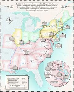
Map of the Marquis de Lafayette's 1824-1825 tour of the United States
3.
Map of the United States, showing by colors the area of freedom and slavery, and the territories whose destiny is yet to be...
4.
Map of the Southern States, showing the relative proportion of slaves in the different localities
5.
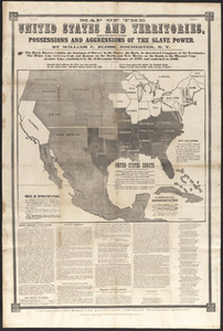
Map of the United States and territories, showing the possessions and aggressions of the slave power
6.
19th annual convention of the National Association of Real Estate Boards : at Tulsa, June 7 to June 11 in 1926
7.
2005 significant U.S. hurricane strikes
8.
The 2100 project : an atlas for the Green New Deal
9.
38,000,000 escaped -- 10,000,000 died
10.
Aboriginal map of North America, denoting the boundaries and the locations of various Indian tribes
11.
The adventures of Mark Twain
12.
Alden's pictorial map of the United States of North America
13.
Alien and Sedition Acts, February 25, 1799, Votes on resolutions for repeal
14.
America : beauty, wonders, inspiration, progress, without end
15.
America the wonderland : a pictorial map of the United States
16.
American explorations in the West, 1803-1852
17.
Amérique Septentrionale
18.
Appletons' railway map of the United States and Canada
19.
Appletons' railway map of the United States and the Canadas : representing railways in actual operation, and those in the...
20.
Armour food source map
‹ Prev
Next ›
1
2
3
4
5
…
434
435