Map of the United States and territories, showing the possessions and aggressions of the slave power
Item Information
- Title:
- Map of the United States and territories, showing the possessions and aggressions of the slave power
- Description:
-
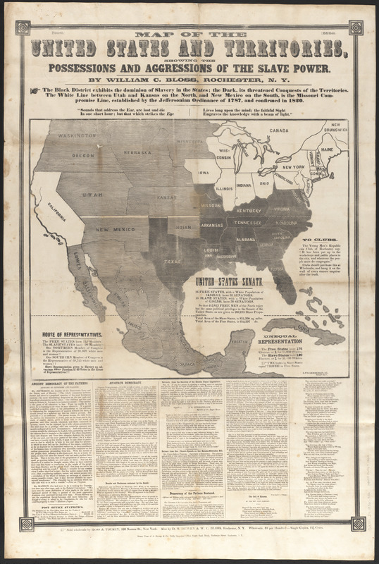
America Transformed: While Colton’s map suggests a unified nation extending from the Atlantic to the Pacific, this broadside published about the same time boldly addresses the slavery issue. It identifies free states in white, slave states in black, and contested territories in gray. Issued during the 1856 presidential election, this stark graphic implicitly supports the candidacy of Republican John C. Frémont, who opposed slavery’s expansion. It also forcefully challenges the so-called Three-Fifths Compromise which counted three out of five slaves toward calculating southern political representation, while denying those enslaved peoples any voting privileges or freedom.
- Cartographer:
- Bloss, William C.
- Engraver:
- Frauenberger, George F.
- Publisher:
- A. Strong & Co.
- Name on Item:
-
by William C. Bloss ; G. Frauenberger, sc.
- Date:
-
[1856]
- Format:
-
Maps/Atlases
- Location:
-
Boston Public Library
Norman B. Leventhal Map & Education Center - Collection (local):
-
Norman B. Leventhal Map & Education Center Collection
- Subjects:
-
Slavery--United States--Maps
- Places:
-
United States
- Extent:
- 1 map ; 49 x 59 cm., on sheet 105 x 71 cm.
- Terms of Use:
-
No known copyright restrictions.
No known restrictions on use.
- Publisher:
-
Rochester, N.Y. :
A. Strong & Co., Daily Democrat Office
- Edition:
- Fourth edition
- Scale:
-
Scale [ca. 1:10,000,000]
- Language:
-
English
- Notes:
-
Shows free, slave, and undetermined states.
Includes text and statistics.
Text, poems, and excerpts on slavery below map. Text references 1856 events.
- Notes (date):
-
This date is inferred.
- Notes (citation):
-
Sabin, J. Dictionary of books relating to America, 5996.
- Notes (exhibitions):
-
Exhibited: "America transformed. Part 1: the United States expands westward," organized by the Norman B. Leventhal Map & Education Center at the Boston Public Library, 2019.
- Identifier:
-
06_01_010413
- Call #:
-
G3701.E9 1856 .B56
- Barcode:
-
39999065671263