Toggle navigation
LMEC Home
Exhibitions
Georeferencing
Tools for Teachers
Collections
My Favorites
Sign Up / Log In
Search
Search the map portal
Map Collection
Map Collection
Map Sets
Search
Search
Search for
Search In
All Fields
Creator
Title
Subject
Place
Search All Digital Collections
Advanced Search
9021 Results
My Search
Start Over
More Like
commonwealth:js956j09k
Remove constraint More Like: commonwealth:js956j09k
Filter your Search
Place
North and Central America
6,248
United States
5,131
Massachusetts
2,098
Europe
1,396
Suffolk (county)
1,068
Boston
1,036
Canada
463
Asia
438
more
Place
»
Topic
Boston (Mass.)--Maps
595
United States--History--Revolution, 1775-1783--Maps
330
United States--Maps
283
Real property--Massachusetts--Boston--Maps
175
Massachusetts--Maps
163
Landowners--Massachusetts--Boston--Maps
133
New England--Maps
104
North America--Maps--Early works to 1800
103
more
Topic
»
Date
Date range begin
–
Date range end
Current results range from
1482
to
2023
View distribution
Creator
United States. Hydrographic Office
595
O.H. Bailey & Co
148
Des Barres, Joseph F. W. (Joseph Frederick Wallet), 1722-1824
124
United States. Post Office Dept
120
Ptolemy, 2nd cent
100
Walling, Henry Francis, 1825-1888
94
Geological Survey (U.S.)
86
Jefferys, Thomas, -1771
86
more
Creator
»
Format
Maps/Atlases
8,956
Manuscripts
219
Prints
56
Books
36
Drawings/Illustrations
13
Objects/Artifacts
10
Posters
5
Georeferenced
Yes
872
No
8,149
Collection
Norman B. Leventhal Map & Education Center Collection
8,695
Boston and New England Maps
2,232
Urban Maps
2,022
Maritime Charts and Atlases
1,083
American Revolutionary War-Era Maps
942
William L. Clements Library Collection
305
Boston Redevelopment Authority Collection
87
Maps from AAS
8
more
Collection
»
Available to use
No known restrictions
8,555
Creative Commons license
52
Search Constraints
Sort by relevance
relevance
title
date (asc)
date (desc)
Number of results to display per page
20 per page
10
per page
20
per page
50
per page
100
per page
View results as:
grid view
map view
Search Results
221.
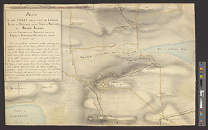
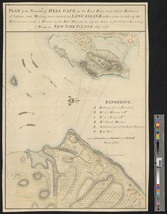
Plan of the narrows of Hell Gate, on the East River near which batteries of cannon, and morters, were erected on Long Island :...
222.
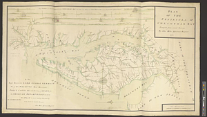
Plan of the peninsula of Chesopeak Bay : compiled from actual surveys
223.
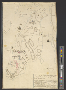
Plan of the position of his majesty's troops at Rhode Island, after the defeat of the rebels the 29th of August 1778
224.
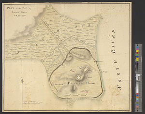
Plan of the post at Paulus's Hook, 24 July 1778
225.
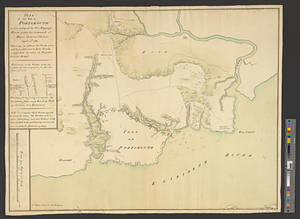
Plan of the post of Portsmouth as it is occupied by his majesty's forces under the command of Major General Phillips, April...
226.
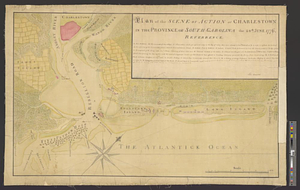
Plan of the scene of action at Charlestown in the province of South Carolina the 28th June 1776
227.
Plan of the seige [sic] of Charlestown in South Carolina
228.
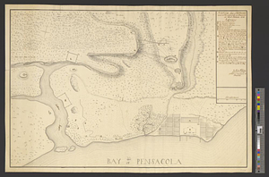
Plan of the siege of Fort George and works adjacent at Pensacola in West Florida, 1781
229.
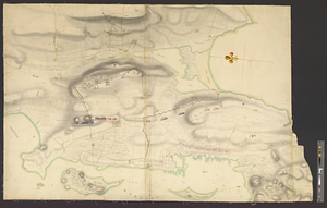
Plan of the town and environs of Newport, Rhode Island : exhibiting its defenses formed before the 8th of August 1778 when the...
230.
Plan of the town and environs of Newport, Rhode Island : exhibiting its defenses formed before the 8th of August 1778 when the...
231.
Plan of the town and harbour of St. Augustin, in East Florida
232.
Plan of the town of Boston with the attack on Bunkers-Hill in the peninsula of Charlestown the 17th of June 1775
233.
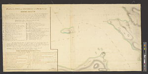
Plan of the town of Newport, and the adjacent country; with a project for its defence : (no. 7)
234.
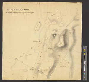
Plan of the town of Newport and the adjacent country, with a project for its defence
235.
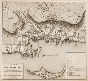
A plan of the town of Newport in Rhode Island
236.
Plan of the town of Savannah, with the works constructed for its defence, together with the approaches & batteries of the...
237.
A plan of the town spot of Morris Town in Morris County for about three miles from the court house, made out from a view of the...
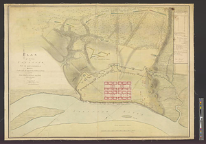
238.
Plan of the works, which form the exterior line of defence, for the town of New-Port in Rhode Island : also of the batteries...
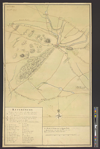
239.
Plan of Washingtons position
240.
Plan of West Point, Virginia
‹ Prev
Next ›
1
2
…
8
9
10
11
12
13
14
15
16
…
451
452
![Plan of the seige [sic] of Charlestown in South Carolina](https://bpldcassets.blob.core.windows.net/derivatives/metadata/commonwealth-oai:rb692949z/image_thumbnail_300.jpg)