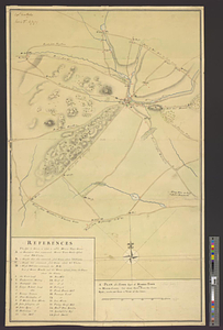
A plan of the town spot of Morris Town in Morris County for about three miles from the court house, made out from a view of the same
This map is also available in American Revolutionary Geographies Online (ARGO), a collections portal especially built for material relating to the American Revolutionary War Era. Visit ARGO to learn more about this item and explore the historical geography of North America in the late eighteenth century.
Item Information
- Title:
- A plan of the town spot of Morris Town in Morris County for about three miles from the court house, made out from a view of the same
- Creator:
- Montrésor, John, 1736-1799
- Date:
-
[ca. 1777]
- Format:
-
Maps/Atlases
- Genre:
-
Manuscript maps
- Location:
- William L. Clements Library
- Collection (local):
-
William L. Clements Library Collection
- Subjects:
-
Morristown (N.J.)--Maps
United States--History--Revolution, 1775-1783--Maps
- Places:
-
New JerseyMorris (county)Morristown
- Extent:
- 1 ms. map : col. ; 83 x 49.2 cm.
- Terms of Use:
-
The University of Michigan Library provides access to these materials for educational and research purposes. These materials may be under copyright. If you decide to use any of these materials, you are responsible for making your own legal assessment and securing any necessary permission. If you have questions about the collection, please contact the William L. Clements Library.
Contact host institution for more information.
- Scale:
-
Scale of chains.
- Language:
-
English
- Catalog Record:
-
Catalog record
- Notes:
-
Signed at upper left: Capt. Montresor, Morris T. N. Jersey.
Finished, colored, topographical map showing the town and immediate countryside.
Principal buildings and residences are identified in a table of references.
Clinton Maps 240.
- Identifier:
-
612
- Barcode:
-
B2667916


