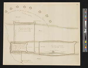
Plan of Washingtons position

This map is also available in American Revolutionary Geographies Online (ARGO), a collections portal especially built for material relating to the American Revolutionary War Era. Visit ARGO to learn more about this item and explore the historical geography of North America in the late eighteenth century.
Item Information
- Title:
- Plan of Washingtons position
- Creator:
- Parker, James, active 1745-1784
- Date:
-
[ca. 1777]
- Format:
-
Maps/Atlases
- Genre:
-
Manuscript maps
- Location:
- William L. Clements Library
- Collection (local):
-
William L. Clements Library Collection
- Subjects:
-
Military camps--Maps
Valley Forge (Pa.)--Maps
United States--History--Revolution, 1775-1783--Maps
- Places:
-
PennsylvaniaChester (county)Valley Forge
- Extent:
- 1 ms. map ; 20.5 x 32.3 cm.
- Terms of Use:
-
The University of Michigan Library provides access to these materials for educational and research purposes. These materials may be under copyright. If you decide to use any of these materials, you are responsible for making your own legal assessment and securing any necessary permission. If you have questions about the collection, please contact the William L. Clements Library.
Contact host institution for more information.
- Scale:
-
Scale indeterminate.
- Language:
-
English
- Catalog Record:
-
Catalog record
- Notes:
-
Title from verso.
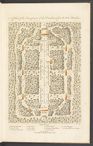
Pen and ink topographical map of Valley Forge with table of references identifying major features.
Further endorsed: Mr Parker late a mercht in Virginia now at Philadelphia.
James Parker (1729-1815) was born in Glasgow and emigrated to America in 1750. Was wealthy merchant in Norfolk and served with Lord Dunmore after the beginning of the Revolution. Relocated to Philadelphia after 1776. Information provided by John Nagy.
Clinton Maps 256.
- Identifier:
-
753
- Barcode:
-
B1938534