Toggle navigation
LMEC Home
Exhibitions
Georeferencing
Tools for Teachers
Collections
My Favorites
Sign Up / Log In
Search
Search the map portal
Map Collection
Map Collection
Map Sets
Search
Search
Search for
Search In
All Fields
Creator
Title
Subject
Place
Search All Digital Collections
Advanced Search
502 Results
My Search
Start Over
More Like
commonwealth:hx11z5595
Remove constraint More Like: commonwealth:hx11z5595
Filter your Search
Place
North and Central America
462
United States
341
New England
129
Canada
115
New York
36
Massachusetts
30
Essex (county)
24
Suffolk (county)
22
more
Place
»
Topic
New England--Maps
127
United States--History--French and Indian War, 1754-1763--Maps, Manuscript--Early works to 1800
58
Railroads--New England--Maps
50
New York (State)--Maps
20
Louisbourg (N.S.)--Maps, Manuscript--Early works to 1800
18
Fort Edward (N.Y.)--Maps, Manuscript--Early works to 1800
16
Fort Ticonderoga (N.Y.)--Maps, Manuscript--Early works to 1800
15
Saint Lawrence River--Maps, Manuscript--Early works to 1800
15
more
Topic
»
Date
Date range begin
–
Date range end
Current results range from
1664
to
2015
View distribution
Creator
Royal United Services Institute for Defence and Security Studies
160
George, III, King of Great Britain, 1738-1820
152
George, IV, King of Great Britain, 1762-1830
151
Amherst, Jeffery Amherst, Baron, 1717-1797
128
Skinner, Monier
28
Skinner, William, 1700-1780
28
Brasier, William
16
Bastide, John Henry, approximately 1700-1770
15
more
Creator
»
Format
Maps/Atlases
485
Manuscripts
151
Drawings/Illustrations
15
Georeferenced
Yes
26
No
476
Collection
British Library Collection
376
American Revolutionary War-Era Maps
368
Norman B. Leventhal Map & Education Center Collection
106
Boston and New England Maps
96
Maps from AAS
9
Urban Maps
6
David Judkins Weaver Papers
4
Sidney R. Knafel Map Collection at Phillips Academy
4
more
Collection
»
Available to use
Creative Commons license
377
No known restrictions
106
Search Constraints
Sort by relevance
relevance
title
date (asc)
date (desc)
Number of results to display per page
20 per page
10
per page
20
per page
50
per page
100
per page
View results as:
grid view
map view
Search Results
441.
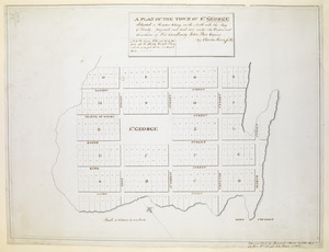
A PLAN OF THE TOWN OF ST. GEORGE Situated in Harbor Etang on the North side the Bay of Fundy, projected and laid out under the...
442.
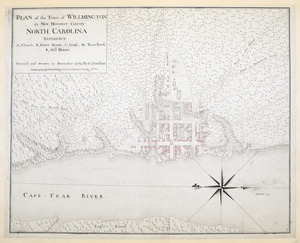
PLAN of the Town of WILLMINGTON in New Hanover County NORTH CAROLINA
443.
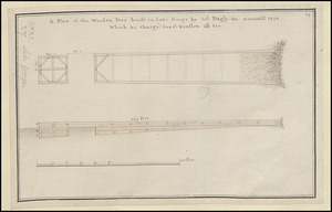
A Plan of the Wooden Peer built in Lake George by Col. Bagly in novemb:r 1756 Which he charged Genr:l Winslow 60:L for
444.
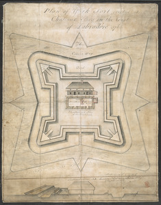
Plan of York Fort erected at Chateaux bay on the Coast of Labradore 1766
445.
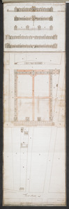
Plans & Sections of Houses for Officers & Barracks for Soldiers near the City of Philadelphia
446.
Plans & Sections of Houses for Officers & Barracks for Soldiers near the City of Philadelphia
447.
Plans & Sections of Houses for Officers & Barracks for Soldiers near the City of Philadelphia
448.
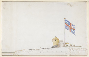
The Profil belonging to the Iconographycal Draft of the Fort William & Mary on Piscataqua River in America
449.
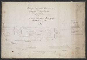
Project for Fortifying the Admiralls Point going into Trinity Harbour Newfoundland Octob.r 1745
450.
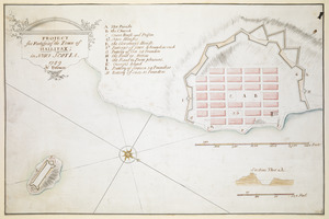
PROJECT for Fortifying the Town of HALLIFAX ; in NOVA SCOTIA
451.
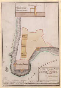
PROJECT for taking POST at CROWN POINT
452.
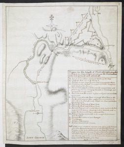
Project for the Attack of Ticonderoga, proposed to be put in executino as near as the circumstances and ground will admit of
453.
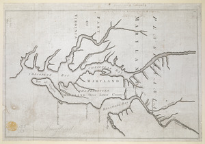
Proposed Maryland / Pennsylvania Boundary
454.
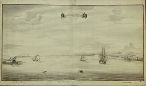
A Prospect of LOUISBOURG taken from ye NE Harbour
455.
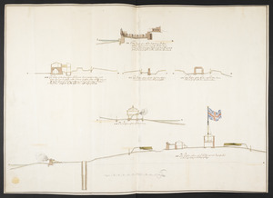
The Respective Profiles belonging to the great Iconografical Draughts of Castle Island in the Bay of Boston
456.
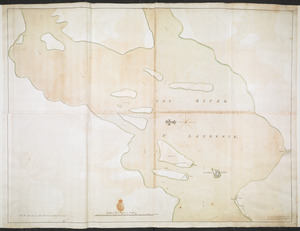
THE RIVER S.T LAURENCE
457.
ROAD OF COUDRE
458.
Rough PLAN of FORT DUQUESNE such as it was before it was demolish'd 1758
459.
Rough PLAN of FORT LIGONIER
460.
SCETCH of the CITY and Environs of S.T AUGUSTINE
‹ Prev
Next ›
1
2
…
19
20
21
22
23
24
25
26