Toggle navigation
LMEC Home
Exhibitions
Georeferencing
Tools for Teachers
Collections
My Favorites
Sign Up / Log In
Search
Search the map portal
Map Collection
Map Collection
Map Sets
Search
Search
Search for
Search In
All Fields
Creator
Title
Subject
Place
Search All Digital Collections
Advanced Search
94 Results
My Search
Start Over
More Like
commonwealth:hq37vv70d
Remove constraint More Like: commonwealth:hq37vv70d
Filter your Search
Place
North and Central America
47
New England
20
United States
17
Massachusetts
16
Arctic
8
Rhode Island
8
New York
7
Connecticut
6
more
Place
»
Topic
New England--Maps--Early works to 1800
15
World maps--Early works to 1800
13
America--Maps--Early works to 1800
9
Arctic regions--Maps--Early works to 1800
8
Massachusetts--Maps
8
North America--Maps--Early works to 1800
8
Western Hemisphere--Maps--Early works to 1800
6
Connecticut--Maps--Early works to 1800
5
more
Topic
»
Date
Date range begin
–
Date range end
Current results range from
1482
to
1990
View distribution
Creator
Ortelius, Abraham, 1527-1598
5
Bew, John, -1793
3
Bordon, Benedetto, 1450-1530
3
Gastaldi, Giacomo, approximately 1500-approximately 1565
3
Hondius, Jodocus, 1594 or 1595-1629
3
Lodge, John, -1796
3
Mercator, Gerhard, 1512-1594
3
Münster, Sebastian, 1489-1552
3
more
Creator
»
Format
Maps/Atlases
94
Books
1
Georeferenced
Yes
9
No
85
Collection
Sidney R. Knafel Map Collection at Phillips Academy
87
American Revolutionary War-Era Maps
25
Norman B. Leventhal Map Center Collection
7
Maritime Charts and Atlases
1
Available to use
No known restrictions
7
Search Constraints
Sort by relevance
relevance
title
date (asc)
date (desc)
Number of results to display per page
50 per page
10
per page
20
per page
50
per page
100
per page
View results as:
grid view
map view
Search Results
1.
Partie de la carte du Capitaine Cluny, auteur d'un ouvrage anglois intitulé American Traveller publié à Londres en 1769
2.
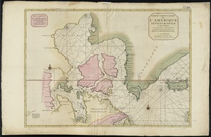
Carte particuliere de l'Amerique septentrionale ou sont compris le Destroit de Davids, le Destroit de Hudson, &c
3.
A map of the icy sea in which the several communications with the land waters and other new discoveries are exhibited
4.
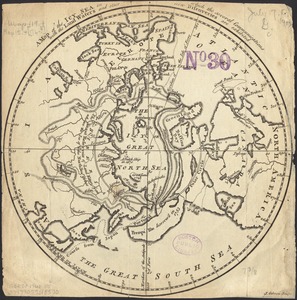
A map of the North Pole with all the territories that lye near it, known to us &c. According to the latest discoveries, and...
5.
Pascaarte vande Noorder Zee custen van America, vande West-hoeck van Ysland doorde Straet Davis en Hudson, tot aen Terra Neuf
6.
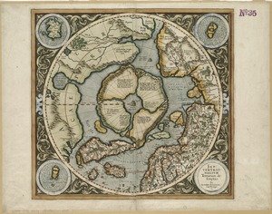
Poli Arctici, et circumiacentium terrarum descriptio novissima
7.
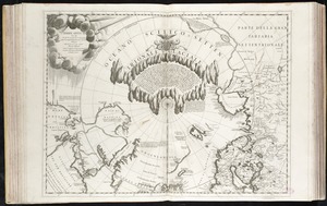
Septentrionalium terrarum descriptio
8.
Terre Artiche
9.
An accurate map of Rhode Island, part of Connecticut and Massachusets, shewing Admiral Arbuthnot's station in blocking up...
10.
An accurate map of the English colonies in North America, bordering on the river Ohio
11.
America
12.
America sive India Nova : ad magnae Gerardi Mercatoris aui universalis imitationem in compendium redacta
13.
America sive novvs orbis respectv Evropaeorvm inferior globi terrestris pars
14.
Americae pars Borealis, Florida, Baccalaos, Canada, Corterealis
15.
Americae siue noui orbis, noua descriptio
16.
Americae siue noui orbis, noua descriptio
17.
The American Atlas or, A Geographical Description of the whole continent of America : wherein are delineated at large, its...
18.
The American pilot : containing the navigation of the sea coat of North America . . .
19.
Atlantic Ocean
20.
L'Atlas de mer ou monde aquatique, remontrant toutes les côtes de la mer, a scavoir de la partie connuë de I'Univers, avec une...
21.
Barnstable County, Dukes County and Nantucket Island, Massachusetts
22.
Baye et port d'Yorc, capitale de la Nouvelle Yorc
23.
Bowles's new pocket map of the most inhabited part of New England : comprehending the provinces of Massachusets Bay and New...
24.
Carta marina nova tabula
25.
Carte de la Nouvelle Angleterre, New York, Pensilvanie et Nouveau Jersay suivant les cartes angloises
26.
Carte de la Nouvelle Angleterre, Nouvelle York, Nouvelle Jersey et Pensilvanie
27.
Chart and plan of the harbour of New York & the couny. adjacent, from Sandy Hook to Kingsbridge, comprehending the whole of New...
28.
Chart for the journal of Mr. le Mquis. de Chastellux
29.
A chart of the gulf stream
30.
Costes et rivieres de Virginie, de Mariland, et de Nouvelle Angletere
31.
The English pilot. The fourth book. Describing the West-India navigation, from Hudson's-Bay to the River Amazones. Particulary...
32.
Garden of Eden
33.
Generale Ptholemei
34.
Geological map of Massachusetts
35.
The harbor of Holmes' Hole
36.
Herbipolis occidens Wurtzpurg
37.
La heroike enterprinse faict par le Signeur Draeck d'avoir cirquit toute la terre
38.
A map of Massachusetts, from the best authorities
39.
Map of Massachusetts, from the best authorities
40.
A map of New England, New York, New Jersey and Pensilvania
41.
A map of New-England, being the first that ever was here cut, and done by the best pattern that could be had, which being in...
42.
A map of the British and French dominions in North America with the roads, distances, limits, and extent of the settlements,...
43.
Map of the Caribbean Area
44.
Map of the northern, or, New England states of America, comprehending Vermont, New Hampshire, District of Main, Massachusetts,...
45.
Map of the northern part of New England : compiled for Pres't. Dwight's travels
46.
A map of the province of Massachusets Bay and colony of Rhode Island, with part of Connecticut, New Hampshire, and Vermont
47.
Map of the southern part of New England : compiled for Pres't. Dwights travels
48.
Maris Pacifici (quod vulgo Mar del Zur) cum regionibus circumiacentibus, insulisque in eodem passim sparsis, novissima descriptio
49.
Massachusetts
50.
Massachusetts
‹ Prev
Next ›
1
2