Toggle navigation
LMEC Home
Exhibitions
Georeferencing
Tools for Teachers
Collections
My Favorites
Sign Up / Log In
Search
Search the map portal
Map Collection
Map Collection
Map Sets
Search
Search
Search for
Search In
All Fields
Creator
Title
Subject
Place
Search All Digital Collections
Advanced Search
8651 Results
My Search
Start Over
More Like
commonwealth:8336h3587
Remove constraint More Like: commonwealth:8336h3587
Filter your Search
Place
North and Central America
5,891
United States
4,811
Massachusetts
2,068
Europe
1,392
Suffolk (county)
1,041
Boston
1,014
Canada
449
Asia
436
more
Place
»
Topic
Boston (Mass.)--Maps
582
United States--Maps
279
Real property--Massachusetts--Boston--Maps
175
Massachusetts--Maps
161
Landowners--Massachusetts--Boston--Maps
133
North America--Maps--Early works to 1800
102
New England--Maps
101
Europe--Maps
79
more
Topic
»
Date
Date range begin
–
Date range end
Current results range from
1482
to
2023
View distribution
Creator
United States. Hydrographic Office
595
O.H. Bailey & Co
148
Des Barres, Joseph F. W. (Joseph Frederick Wallet), 1722-1824
123
United States. Post Office Dept
120
Ptolemy, 2nd cent
100
Walling, Henry Francis, 1825-1888
94
Geological Survey (U.S.)
86
Jefferys, Thomas, -1771
85
more
Creator
»
Format
Maps/Atlases
8,591
Manuscripts
215
Prints
56
Books
36
Objects/Artifacts
10
Drawings/Illustrations
8
Posters
5
Georeferenced
Yes
869
No
7,782
Collection
Norman B. Leventhal Map & Education Center Collection
8,644
Boston and New England Maps
2,220
Urban Maps
1,991
Maritime Charts and Atlases
1,083
American Revolutionary War-Era Maps
621
Boston Redevelopment Authority Collection
87
William L. Clements Library Collection
7
Available to use
No known restrictions
8,502
Creative Commons license
47
Search Constraints
Sort by relevance
relevance
title
date (asc)
date (desc)
Number of results to display per page
20 per page
10
per page
20
per page
50
per page
100
per page
View results as:
grid view
map view
Search Results
1.
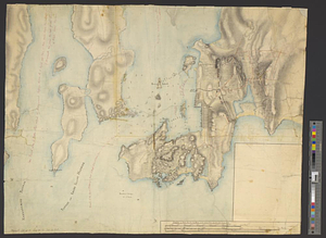
Newport and its environs, ca. 1778
2.
Partie de l'état de Rhode-Island et position des armées Américaine et Britannique au siege de Newport et à l'affaire du 29 Août...
3.
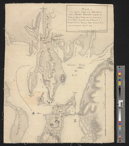
Plan of the adjacent coast to the northern part of Rhode Island, to express the route of a body of troops under the command of...
4.
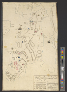
Plan of the position of his majesty's troops at Rhode Island, after the defeat of the rebels the 29th of August 1778
5.
Plan of the town and environs of Newport, Rhode Island : exhibiting its defenses formed before the 8th of August 1778 when the...
6.
Plan of the town and environs of Newport, Rhode Island : exhibiting its defenses formed before the 8th of August 1778 when the...
7.
Plan of the works, which form the exterior line of defence, for the town of New-Port in Rhode Island : also of the batteries...
8.
The 100th anniversary map of Abraham Lincoln's visit to Massachusetts, September 11-23, 1848
9.
1630 shoreline
10.
1879. Progress map of the U.S. Geographical Surveys west of the 100th Meridian : prepared under the direction of 1st Lieut....
11.
1903 Map of Salem and surrounding places
12.
19th annual convention of the National Association of Real Estate Boards : at Tulsa, June 7 to June 11 in 1926
13.
2005 significant U.S. hurricane strikes
14.
The 2100 project : an atlas for the Green New Deal
15.
227 Harzgerode
16.
305 Glatz
17.
38,000,000 escaped -- 10,000,000 died
18.
4 Kinten
19.
660 Wakulah St., Roxbury
20.
74 miles on the ocean scenic highway U.S. 1
‹ Prev
Next ›
1
2
3
4
5
…
432
433