Toggle navigation
LMEC Home
Exhibitions
Georeferencing
Tools for Teachers
Collections
My Favorites
Sign Up / Log In
Search
Search the map portal
Map Collection
Map Collection
Map Sets
Search
Search
Search for
Search In
All Fields
Creator
Title
Subject
Place
Search All Digital Collections
Advanced Search
508 Results
My Search
Start Over
More Like
commonwealth:5138mw65z
Remove constraint More Like: commonwealth:5138mw65z
Filter your Search
Place
North and Central America
505
United States
502
Suffolk (county)
494
Boston
493
Massachusetts
194
Roxbury
54
Fens
51
South End
50
more
Place
»
Topic
City planning--Massachusetts--Boston--Maps
417
Urban renewal--Massachusetts--Boston--Maps
253
Boston (Mass.)--Maps
146
Land use--Massachusetts--Boston--Maps
101
Buildings--Massachusetts--Boston--Maps
81
Real property--Massachusetts--Boston--Maps
56
Fenway (Boston, Mass.)--Maps
55
Roxbury (Boston, Mass.)--Maps
50
more
Topic
»
Date
Date range begin
–
Date range end
Current results range from
1835
to
2014
View distribution
Creator
Boston Redevelopment Authority
370
Downtown Waterfront Corporation
10
Victor Gruen Associates
10
Boston (Mass.). Parks and Recreation Department
8
Sasaki Associates
6
Boston (Mass.). Department of Parks
5
Boston (Mass.). Water and Sewer Commission
5
Charles A. Maguire and Associates
5
more
Creator
»
Format
Maps/Atlases
507
Drawings/Illustrations
3
Manuscripts
1
Prints
1
Georeferenced
Yes
6
No
502
Collection
Boston and New England Maps
494
Urban Maps
479
Boston Redevelopment Authority Collection
441
Norman B. Leventhal Map & Education Center Collection
121
Massachusetts Real Estate Atlases
1
Available to use
No known restrictions
506
Search Constraints
Sort by date (desc)
relevance
title
date (asc)
date (desc)
Number of results to display per page
20 per page
10
per page
20
per page
50
per page
100
per page
View results as:
grid view
map view
Search Results
1.
Boston streets & neighborhoods
2.
Commonwealth of Massachusetts U.S. congressional districts
3.
Area plan as of May 1962
4.
South China Sea, Gulf of Tonkin, Vietnam--China, C'ua Nhuong to Leizhou Bandao including Hainan Dao
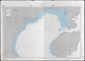
5.
Asia, South China Sea, Mui Da Nang to Shenquan Gang including Hainan Dao and Parcel Islands
6.
Circulation plan of parking lot at the corner of VFW Parkway and Spring Street, West Roxbury
7.
Berkeley Street community garden
8.
Longwood Medical Area
9.
Flirtation walk schematic planting plan Charlestown Navy Yard
10.
Planting beds on Dartmouth Street and Boylston Street in Copley Square
11.
Brighton and Allston urban design strategy
12.
Columbia Point updated base maps
13.
Flirtation walk existing conditions plan Charlestown Navy Yard
14.
Gate 5 - Chelsea Street modified landscape scheme, Charlestown, MA
15.
Illustrative site plan : a proposal for community review South End/Lower Roxbury development policy
16.
Illustrative site plan : a proposal for community review South End/Lower Roxbury development policy
17.
Little Mystic Channel landscape scheme, Charlestown, MA
18.
Outline map of Boston
19.
Ropewalk bldg. Charlestown Navy Yard
20.
Street trees Comm. Ave.
‹ Prev
Next ›
1
2
3
4
5
…
25
26