Toggle navigation
LMEC Home
Exhibitions
Georeferencing
Tools for Teachers
Collections
My Favorites
Sign Up / Log In
Search
Search the map portal
Map Collection
Map Collection
Map Sets
Search
Search
Search for
Search In
All Fields
Creator
Title
Subject
Place
Search All Digital Collections
Advanced Search
8577 Results
My Search
Start Over
More Like
commonwealth:4m90fk533
Remove constraint More Like: commonwealth:4m90fk533
Filter your Search
Place
North and Central America
5,851
United States
4,769
Massachusetts
2,052
Europe
1,359
Suffolk (county)
1,034
Boston
1,007
Canada
448
Asia
422
more
Place
»
Topic
Boston (Mass.)--Maps
577
United States--Maps
273
Real property--Massachusetts--Boston--Maps
174
Massachusetts--Maps
160
Landowners--Massachusetts--Boston--Maps
132
North America--Maps--Early works to 1800
103
New England--Maps
99
Europe--Maps
78
more
Topic
»
Date
Date range begin
–
Date range end
Current results range from
1482
to
2023
View distribution
Creator
United States. Hydrographic Office
594
O.H. Bailey & Co
148
Des Barres, Joseph F. W. (Joseph Frederick Wallet), 1722-1824
123
United States. Post Office Dept
120
Ptolemy, 2nd cent
100
Walling, Henry Francis, 1825-1888
94
Geological Survey (U.S.)
86
Jefferys, Thomas, -1771
86
more
Creator
»
Format
Maps/Atlases
8,518
Manuscripts
216
Prints
56
Books
36
Objects/Artifacts
10
Drawings/Illustrations
8
Posters
4
Georeferenced
Yes
873
No
7,704
Collection
Norman B. Leventhal Map & Education Center Collection
8,550
Boston and New England Maps
2,204
Urban Maps
1,936
Maritime Charts and Atlases
1,082
American Revolutionary War-Era Maps
642
Boston Redevelopment Authority Collection
87
American Antiquarian Society Collection
18
William L. Clements Library Collection
8
more
Collection
»
Available to use
No known restrictions
8,409
Creative Commons license
46
Search Constraints
Sort by relevance
relevance
title
date (asc)
date (desc)
Number of results to display per page
10 per page
10
per page
20
per page
50
per page
100
per page
View results as:
grid view
map view
Search Results
1.
Map of the United States of America, the British Provinces, Mexico, the West Indies and Central America, with part of New...
2.
Map of Central America, Cuba, Porto Rico, and the islands of the Caribbean Sea
3.
Map of the United States of America, Mexico, Central America, and the West India Islands
4.
Map of the United States of America, the British provinces, Mexico, the West Indies and Central America, with part of New...
5.
Map of the United States, British & Central America : from state documents & unpublished materials
6.
The Evening Post map of the West Indies
7.
Gulf of Mexico, West Indies and Caribbean Sea : from the most recent U.S. Coast Survey, Spanish and British Admiralty charts
8.
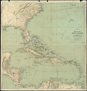
Map of the West Indies
9.
The West India Islands and adjacent territory showing British possessions south of the United States
10.
Chart of the West Indies and Spanish Dominions in North America
‹ Prev
Next ›
1
2
3
4
5
…
857
858