Toggle navigation
LMEC Home
Exhibitions
Georeferencing
Tools for Teachers
Collections
My Favorites
Sign Up / Log In
Search
Search the map portal
Map Collection
Map Collection
Map Sets
Search
Search
Search for
Search In
All Fields
Creator
Title
Subject
Place
Search All Digital Collections
Advanced Search
504 Results
My Search
Start Over
More Like
commonwealth:2n49wm032
Remove constraint More Like: commonwealth:2n49wm032
Filter your Search
Place
North and Central America
501
United States
498
Suffolk (county)
490
Boston
489
Massachusetts
191
South End
49
Roxbury
47
Downtown Boston
40
more
Place
»
Topic
City planning--Massachusetts--Boston--Maps
418
Urban renewal--Massachusetts--Boston--Maps
253
Boston (Mass.)--Maps
154
Land use--Massachusetts--Boston--Maps
102
Buildings--Massachusetts--Boston--Maps
81
Real property--Massachusetts--Boston--Maps
49
Roxbury (Boston, Mass.)--Maps
43
South End (Boston, Mass.)--Maps
42
more
Topic
»
Date
Date range begin
–
Date range end
Current results range from
1835
to
2020
View distribution
Creator
Boston Redevelopment Authority
370
Massachusetts Bay Transportation Authority
12
Downtown Waterfront Corporation
10
Victor Gruen Associates
10
Boston (Mass.). Parks and Recreation Department
9
Boston Elevated Railway Company
8
General Drafting Company
8
Sasaki Associates
6
more
Creator
»
Format
Maps/Atlases
503
Drawings/Illustrations
3
Manuscripts
1
Prints
1
Georeferenced
Yes
5
No
499
Collection
Boston and New England Maps
470
Urban Maps
452
Boston Redevelopment Authority Collection
439
Norman B. Leventhal Map & Education Center Collection
118
Applied Geographics, Inc. Records
1
David Judkins Weaver Papers
1
Available to use
No known restrictions
502
Creative Commons license
1
Search Constraints
Sort by relevance
relevance
title
date (asc)
date (desc)
Number of results to display per page
20 per page
10
per page
20
per page
50
per page
100
per page
View results as:
grid view
map view
Search Results
281.
Charlestown urban renewal project Boston (Suffolk County) Massachusetts Mass. R-55 : topographic map
282.
Columbia Point development study
283.
Columbia Point updated base maps
284.
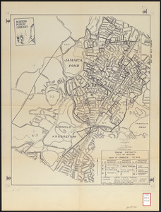
Jamaica Pond master plan
285.
James Hayes Park
286.
Olmsted Park master plan
287.
Outline map of Boston
288.
The Riverway master plan
289.
South End urban renewal area project Mass. r-56 : site preparation contract no. 16 street lighting and drainage
290.
Union Park landscape improvements
291.
View of the South End
292.
Washington Street boulevard study : proposed fabric
293.
Washington Street boulevard study : corridor wide urban design strategy
294.
Boston traffic map showing one way streets and parking spaces
295.
Infrastructure around Tobin Bridge/US route 1 in Charlestown
296.
Major transportation system : Boston region MAPC area
297.
Blue Hill Avenue commercial strip
298.
Boston University, Charles River campus master plan
299.
Use of land in Boston
300.
Zoning districts city of Boston map 9 Jamaica Plain
‹ Prev
Next ›
1
2
…
11
12
13
14
15
16
17
18
19
…
25
26