Toggle navigation
LMEC Home
Exhibitions
Georeferencing
Tools for Teachers
Collections
My Favorites
Sign Up / Log In
Search
Search the map portal
Map Collection
Map Collection
Map Sets
Search
Search
Search for
Search In
All Fields
Creator
Title
Subject
Place
Search All Digital Collections
Advanced Search
8755 Results
My Search
Start Over
More Like
commonwealth:1831g784x
Remove constraint More Like: commonwealth:1831g784x
Filter your Search
Place
North and Central America
5,955
United States
4,846
Massachusetts
2,078
Europe
1,396
Suffolk (county)
1,045
Boston
1,018
Canada
480
Asia
438
more
Place
»
Topic
Boston (Mass.)--Maps
586
United States--Maps
282
Real property--Massachusetts--Boston--Maps
175
Massachusetts--Maps
162
Landowners--Massachusetts--Boston--Maps
133
North America--Maps--Early works to 1800
103
New England--Maps
102
Europe--Maps
79
more
Topic
»
Date
Date range begin
–
Date range end
Current results range from
1482
to
2023
View distribution
Creator
United States. Hydrographic Office
594
Des Barres, Joseph F. W. (Joseph Frederick Wallet), 1722-1824
185
O.H. Bailey & Co
148
United States. Post Office Dept
120
Ptolemy, 2nd cent
100
Walling, Henry Francis, 1825-1888
94
Geological Survey (U.S.)
86
Jefferys, Thomas, -1771
85
more
Creator
»
Format
Maps/Atlases
8,695
Manuscripts
215
Prints
56
Books
36
Objects/Artifacts
10
Drawings/Illustrations
8
Posters
5
Georeferenced
Yes
869
No
7,886
Collection
Norman B. Leventhal Map & Education Center Collection
8,693
Boston and New England Maps
2,232
Urban Maps
2,023
Maritime Charts and Atlases
1,082
American Revolutionary War-Era Maps
677
Boston Redevelopment Authority Collection
87
Library of Congress Collection
62
Available to use
No known restrictions
8,551
Creative Commons license
109
Search Constraints
Sort by relevance
relevance
title
date (asc)
date (desc)
Number of results to display per page
20 per page
10
per page
20
per page
50
per page
100
per page
View results as:
grid view
map view
Search Results
1.
A chart of the North-American coast, for the navigation between Halifax and Philadelphia
2.
Dominion of Canada, Nova Scotia, Ship Harbor and adjacent anchorages : from a British survey in 1854
3.
North America, Dominion of Canada, Gulf of St. Lawrence, Prince Edward Island and adjacent coasts, from Sea Wolf Island to...
4.
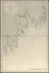
North America--east coast, Nova Scotia--south east coast, Baccaro Point to Ram Island
5.
S.e. coast of Nova Scotia : from the most recent British surveys
6.
A small map of the sea coast of New England together with the outlines of several of the provinces lying thereon, 1738
7.
Annapolis Royal ; St. Mary's Bay
8.
Annapolis Royal ; St. Mary's Bay
9.
Annapolis Royal ; St. Mary's Bay
10.
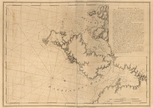
Barrington Bay
11.
Barrington Bay
12.
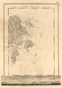
Canso Harbor
13.
Canso Harbor
14.
Charlotte Bay
15.
A chart of Nova Scotia
16.
A chart of Nova Scotia
17.
Crow Harbor, on the south shore of Chedabuctou Bay
18.
Egmont Harbor
19.
Egmont Harbor
20.
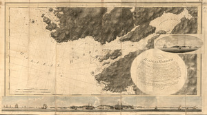
Halifax Harbour ... Catch Harbour ...
‹ Prev
Next ›
1
2
3
4
5
…
437
438