Toggle navigation
LMEC Home
Exhibitions
Georeferencing
Tools for Teachers
Collections
My Favorites
Sign Up / Log In
Search
Search the map portal
Map Collection
Map Collection
Map Sets
Search
Search
Search for
Search In
All Fields
Creator
Title
Subject
Place
Search All Digital Collections
Advanced Search
8742 Results
My Search
Start Over
More Like
commonwealth:0z709278h
Remove constraint More Like: commonwealth:0z709278h
Filter your Search
Place
North and Central America
5,973
United States
4,862
Massachusetts
2,079
Europe
1,396
Suffolk (county)
1,046
Boston
1,019
Canada
477
Asia
438
more
Place
»
Topic
Boston (Mass.)--Maps
586
United States--Maps
282
Real property--Massachusetts--Boston--Maps
175
Massachusetts--Maps
163
Landowners--Massachusetts--Boston--Maps
133
New England--Maps
106
North America--Maps--Early works to 1800
103
Europe--Maps
79
more
Topic
»
Date
Date range begin
–
Date range end
Current results range from
1482
to
2023
View distribution
Creator
United States. Hydrographic Office
595
O.H. Bailey & Co
148
Des Barres, Joseph F. W. (Joseph Frederick Wallet), 1722-1824
123
United States. Post Office Dept
120
Ptolemy, 2nd cent
100
Walling, Henry Francis, 1825-1888
94
Geological Survey (U.S.)
90
Jefferys, Thomas, -1771
85
more
Creator
»
Format
Maps/Atlases
8,682
Manuscripts
218
Prints
56
Books
36
Objects/Artifacts
10
Drawings/Illustrations
8
Posters
5
Georeferenced
Yes
869
No
7,873
Collection
Norman B. Leventhal Map & Education Center Collection
8,699
Boston and New England Maps
2,238
Urban Maps
2,023
Maritime Charts and Atlases
1,083
American Revolutionary War-Era Maps
657
Boston Redevelopment Authority Collection
87
William L. Clements Library Collection
22
American Antiquarian Society Collection
9
more
Collection
»
Available to use
No known restrictions
8,557
Creative Commons license
49
Search Constraints
Sort by relevance
relevance
title
date (asc)
date (desc)
Number of results to display per page
20 per page
10
per page
20
per page
50
per page
100
per page
View results as:
grid view
map view
Search Results
7421.
Sketch of sea coast of South Carolina and Georgia from Bull's Bay to Ossabaw Sound
7422.
Sketch of the 11th district of western Tennessee
7423.
Sketch of the Battle of Bunker Hill
7424.
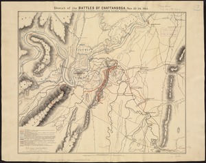
Sketch of the battles of Chattanooga, Nov. 23-26, 1863
7425.
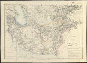
Sketch of the countries between Hindustan and the Caspian Sea
7426.
Sketch of the country illustrating the late engagement in Long Island
7427.
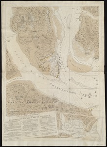
A sketch of the environs of Charlestown in South Carolina
7428.
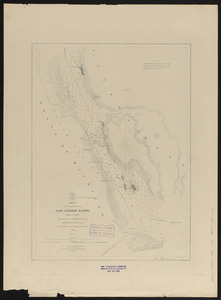
Sketch of the narrows in Boston Harbor
7429.
Sketch of the navigation through East Neebish Rapids, River St. Marys
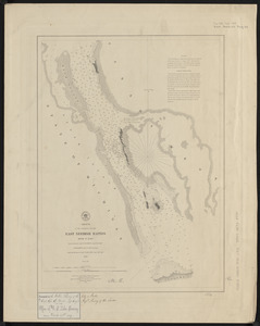
7430.
Sketch of the navigation through East Neebish Rapids River St. Marys
7431.
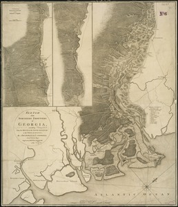
Sketch of the northern frontiers of Georgia, extending from the mouth of the River Savannah to the town of Augusta
7432.
A sketch of the operations before Charlestown the capital of South Carolina
7433.
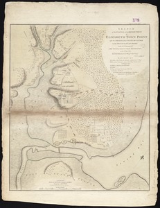
Sketch of the position of the British forces at Elizabeth Town Point after their return from Connecticut Farm, in the province...
7434.
[Sketch of the region of the island of Cape Breton, between the parallels of forty-five and forty-eight degrees of latitude]
7435.
Sketch of the states of Massachusetts, Connecticut, and Rhode Island, and parts of New Hampshire & New York exhibiting the...
7436.
Sketch of the states of Massachusetts, Connecticut, and Rhode Island, and parts of New Hampshire & New York exhibiting the...
7437.
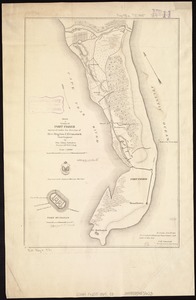
Sketch of vicinity of Fort Fisher
7438.
Sketch plan showing the existing and proposed public reservations upon the banks of the Charles between Waltham line and...
7439.
Sketch showing a feasible canal route, Allegheny River to Lake Erie.
7440.
Sketch showing arrangement for park-way with adjacent streets and building lots
‹ Prev
Next ›
1
2
…
368
369
370
371
372
373
374
375
376
…
437
438


![[Sketch of the region of the island of Cape Breton, between the parallels of forty-five and forty-eight degrees of latitude]](https://bpldcassets.blob.core.windows.net/derivatives/images/commonwealth:4m90fh38k/image_thumbnail_300.jpg)