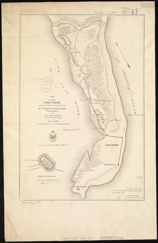
Sketch of vicinity of Fort Fisher
Item Information
- Title:
- Sketch of vicinity of Fort Fisher
- Creator:
- Schultze, Otto Julian.
- Name on Item:
-
surveyed under the direction of Brvt. Brig. Gen. C.B. Comstock, chief engineer, by Otto Julian Schultze, Private, 15th N.Y. V. Eng.
- Date:
-
[1865?]
- Format:
-
Maps/Atlases
- Location:
-
Boston Public Library
Norman B. Leventhal Map & Education Center - Collection (local):
-
Norman B. Leventhal Map & Education Center Collection
- Subjects:
-
Fort Fisher (N.C. : Fort)--History--19th century--Maps
- Places:
-
North CarolinaNew Hanover (county)Fort Fisher (historic site)
- Extent:
- 1 map ; 37 x 25 cm.
- Terms of Use:
-
No known copyright restrictions.
No known restrictions on use.
- Publisher:
-
Washington, D.C.? :
U.S. War Dept., Engineer Bureau
- Scale:
-
Scale 1:12,000.
- Language:
-
English
- Notes:
-
Ft. Fisher, Feb. 9th, 1865, forwarded to Engineer Department with letter of this date, C.B. Comstock, Lt. Col. A.D.C. & Brvt. B. Gen.
Relief shown by hachures.
Includes inset of Fort Buchanan.
- Identifier:
-
06_01_007460
- Call #:
-
G3904.F62S5 1865 .S3
- Barcode:
-
39999059031623
39999059032829
39999059032837
- LCCN:
-
86690227


