Toggle navigation
LMEC Home
Exhibitions
Georeferencing
Tools for Teachers
Collections
My Favorites
Sign Up / Log In
Search
Search the map portal
Map Collection
Map Collection
Map Sets
Search
Search
Search for
Search In
All Fields
Creator
Title
Subject
Place
Search All Digital Collections
Advanced Search
13385 Results
Filter your Search
Place
North and Central America
10,111
United States
8,249
Massachusetts
2,691
Suffolk (county)
1,664
Boston
1,621
Europe
1,386
Canada
949
New York
640
more
Place
»
Topic
Boston (Mass.)--Maps
741
City planning--Massachusetts--Boston--Maps
418
United States--History--Revolution, 1775-1783--Maps
329
United States--Maps
315
Urban renewal--Massachusetts--Boston--Maps
254
Real property--Massachusetts--Boston--Maps
252
Massachusetts--Maps
219
Insurance surveys
197
more
Topic
»
Date
Date range begin
–
Date range end
Current results range from
1482
to
2023
View distribution
Creator
United States. Hydrographic Office
595
Boston Redevelopment Authority
403
Des Barres, Joseph F. W. (Joseph Frederick Wallet), 1722-1824
247
Royal United Services Institute for Defence and Security Studies
160
Jefferys, Thomas, -1771
154
George, III, King of Great Britain, 1738-1820
152
George, IV, King of Great Britain, 1762-1830
151
O.H. Bailey & Co
148
more
Creator
»
Format
Maps/Atlases
13,205
Manuscripts
985
Prints
102
Books
49
Drawings/Illustrations
44
Photographs
15
Objects/Artifacts
13
Documents
7
more
Format
»
Georeferenced
Yes
979
No
12,406
Collection
Norman B. Leventhal Map & Education Center Collection
8,891
American Revolutionary War-Era Maps
3,305
Boston and New England Maps
2,804
Urban Maps
2,397
Maritime Charts and Atlases
1,150
William L. Clements Library Collection
910
Library of Congress Collection
618
Boston Redevelopment Authority Collection
475
more
Collection
»
Available to use
No known restrictions
9,952
Creative Commons license
1,677
Search Constraints
Sort by relevance
relevance
title
date (asc)
date (desc)
Number of results to display per page
20 per page
10
per page
20
per page
50
per page
100
per page
View results as:
grid view
map view
Search Results
5281.
Map of Port Angeles, Washington Territory : compiled from a true copy of the U.S. survey thereof on file in the General Land...
5282.
Map of Port Arthur
5283.
Map of Portage Co., Ohio
5284.
Map of portion of Osoyoos District : British Columbia
5285.
Map of portion of Osoyoos District, B.C
5286.
Map of portion of Osoyoos District, British Columbia
5287.
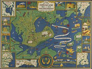
A map of Portland Maine and some places thereabout
5288.
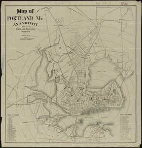
Map of Portland, Me. and vicinity
5289.
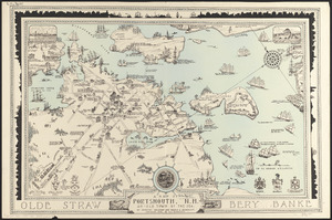
A map of Portsmouth, N.H. : an old town by the sea
5290.
A map of Potomack and James rivers in North America shewing their several communications with the navigable waters of the new...
5291.
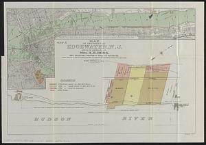
Map of property at Edgewater, N.J.
5292.
Map of property of the Surf Side Syndicate, Nantucket, Mass.
5293.
Map of proposed arboretum, showing its outlines and local connections, with a study for public drive passing through it
5294.
Map of Providence County, Rhode Island, with some of the adjacent towns
5295.
Map of Providence, Rhode Island
5296.
Map of public transportation routes in Greater Boston served by the Massachusetts Bay Transportation Authority comprising 64...
5297.
Map of Putnam
5298.
[Map of Quebec and environs showing the position of the English and French troops]
5299.
Map of Quebec City with plans of the citadel by Captain Samuel Holland for Report of the government of Quebec and dependencies
5300.
Map of Queens Village or Lloyd Neck in Queens County on the north side of Long Island in the Province (now State) of New York....
‹ Prev
Next ›
1
2
…
261
262
263
264
265
266
267
268
269
…
669
670


![[Map of Quebec and environs showing the position of the English and French troops]](https://bpldcassets.blob.core.windows.net/derivatives/images/commonwealth:hx11xz61s/image_thumbnail_300.jpg)