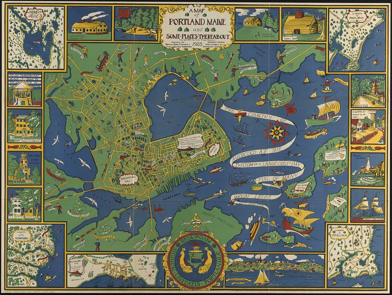
A map of Portland Maine and some places thereabout
Item Information
- Title:
- A map of Portland Maine and some places thereabout
- Cartographer:
- Dudley, Katherine
- Copyright holder:
- Tudor Press
- Publisher:
- Portland Baby Hygiene & Child Welfare Association
- Name on Item:
-
designed, drawn and colored by Katherine Dudley
- Date:
-
1928
- Format:
-
Maps/Atlases
- Genre:
-
Pictorial maps
- Location:
-
Boston Public Library
Norman B. Leventhal Map & Education Center - Collection (local):
-
Norman B. Leventhal Map & Education Center Collection
- Subjects:
-
Portland (Me.)--Maps
- Places:
-
MaineCumberland (county)Portland
- Extent:
- 1 map : color ; 74 x 99 cm, folded in envelope 28 x 37 cm
- Terms of Use:
-
No known copyright restrictions.
No known restrictions on use.
- Publisher:
-
[Portland, Me.] :
Portland Baby Hygiene & Child Welfare Association
- Scale:
-
Scale approximately 1:12,500
- Language:
-
English
- Notes:
-
Oriented with north to the upper right.
Some buildings shown pictorially.
Includes notes about locations or historic events.
Border includes 5 maps, 13 illustrations of buildings or places, and illustration of the city seal.
Maps in border: Sebago Lake -- A mappe of the Kennebunks -- Falmouth Neck 1775 as it was when destroyed by Mowett -- A mappe of Cape Elizabeth -- A mappe of Prout's Neck.
"Copyright 1928, the Tudor Press, Boston."
- Identifier:
-
06_01_016976
- Call #:
-
G3734.P8A5 1928 .D83
- Barcode:
-
39999085952966