Toggle navigation
LMEC Home
Exhibitions
Georeferencing
Tools for Teachers
Collections
My Favorites
Sign Up / Log In
Search
Search the map portal
Map Collection
Map Collection
Map Sets
Search
Search
Search for
Search In
All Fields
Creator
Title
Subject
Place
Search All Digital Collections
Advanced Search
2893 Results
My Search
Start Over
atlas
Remove constraint atlas
Filter your Search
Place
North and Central America
1,677
United States
1,013
Europe
471
Massachusetts
363
Canada
271
Asia
193
South America
193
Suffolk (county)
165
more
Place
»
Topic
Landowners--Massachusetts--Boston--Maps
115
Real property--Massachusetts--Boston--Maps
106
United States--Maps
87
Boston (Mass.)--Maps
64
United States--History--French and Indian War, 1754-1763--Maps
63
Saint Lawrence River--Maps
41
Nautical charts--Early works to 1800
39
North America--Maps--Early works to 1800
36
more
Topic
»
Date
Date range begin
–
Date range end
Current results range from
1482
to
2023
View distribution
Creator
United States. Hydrographic Office
584
Des Barres, Joseph F. W. (Joseph Frederick Wallet), 1722-1824
118
Ptolemy, 2nd cent
100
Bromley, George Washington
99
Bromley, Walter Scott
97
G.W. Bromley & Co.
75
Carey, Mathew, 1760-1839
74
Paullin, Charles Oscar, 1868 or 1869-1944
70
more
Creator
»
Format
Maps/Atlases
2,877
Manuscripts
58
Books
37
Prints
8
Documents
5
Drawings/Illustrations
1
Georeferenced
Yes
142
No
2,751
Collection
Norman B. Leventhal Map & Education Center Collection
2,436
Maritime Charts and Atlases
1,169
American Revolutionary War-Era Maps
504
Boston and New England Maps
390
Urban Maps
275
Massachusetts Real Estate Atlases
144
William L. Clements Library Collection
92
Mapping Boston Collection
61
more
Collection
»
Available to use
No known restrictions
2,342
Creative Commons license
158
Search Constraints
Sort by relevance
relevance
title
date (asc)
date (desc)
Number of results to display per page
20 per page
10
per page
20
per page
50
per page
100
per page
View results as:
grid view
map view
Search Results
1521.
Pascaerte van Terra Nova Nova Francia Nievw Engeland En de Groote Revier van Canada
1522.
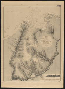
Patagonia w.c., Gulf of Trinidad, Port Henry : from a British survey in 1879
1523.
Pilot chart of the South Pacific
1524.
Plans on the west coast of Patagonia, South America : from the most recent British surveys
1525.
Port Bonavista
1526.
Portage Lake and River with part of Keweenaw Bay
1527.
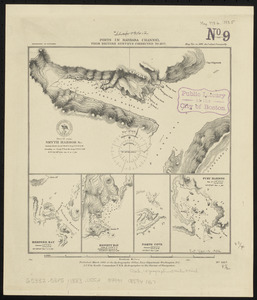
Ports in Barbara Channel : from British surveys corrected to 1877
1528.
Ports in the Philippine Islands
1529.
Preliminary chart : lower reach of Saginaw River and bar in front
1530.
Preliminary chart, lower reach of Saginaw River and bar in front, (Saginaw Bay, Lake Huron)
1531.
Preliminary chart of Eagle River, Lake Superior
1532.
Preliminary chart of Tawas Harbor : (harbor of refuge, Lake Huron)
1533.
Preliminary chart of Tawas Harbor : (harbor of refuge, Lake Huron)
1534.
Raritona Harbour, Island Ya-Asaua, Asaua Group ; Emmons Bay, Island of Ya-Asaua, Asaua Group ; Faliki Harbour, east side of...
1535.
Reconnoissance of Cape Canaveral Shoals on the eastern coast of Florida
1536.
Red Sea, Safájah Island anchorages : from a British survey in 1872
1537.
Red Sea, Strait of Jubal
1538.
Red Sea, Suez Bay : from British surveys in 1870, corrected to 1872
1539.
Remarks
1540.
The River & Gulf of St. Lawrence, Newfoundland, Nova Scotia, and the banks adjacent : from the British Admiralty, French Marine...
‹ Prev
Next ›
1
2
…
73
74
75
76
77
78
79
80
81
…
144
145