Toggle navigation
LMEC Home
Exhibitions
Georeferencing
Tools for Teachers
Collections
My Favorites
Sign Up / Log In
Search
Search the map portal
Map Collection
Map Collection
Map Sets
Search
Search
Search for
Search In
All Fields
Creator
Title
Subject
Place
Search All Digital Collections
Advanced Search
4130 Results
My Search
Start Over
Date Range
before 1800
Remove constraint Date Range: before 1800
All Fields
americas
Remove constraint All Fields: americas
Filter your Search
Place
North and Central America
3,720
United States
2,492
Canada
642
Massachusetts
471
New York
376
North America
307
South America
204
Maine
203
more
Place
»
Topic
United States--History--Revolution, 1775-1783--Maps
321
North America--Maps--Early works to 1800
179
United States--History--French and Indian War, 1754-1763--Maps
161
Manuscript maps--Early works to 1800
121
New England--Maps--Early works to 1800
89
America--Maps--Early works to 1800
73
United States--Maps--Early works to 1800
59
Western Hemisphere--Maps--Early works to 1800
59
more
Topic
»
Date
Date range begin
–
Date range end
Current results range from
1507
to
1899
View distribution
Creator
Des Barres, Joseph F. W. (Joseph Frederick Wallet), 1722-1824
196
Jefferys, Thomas, -1771
149
George, III, King of Great Britain, 1738-1820
146
George, IV, King of Great Britain, 1762-1830
145
Royal United Services Institute for Defence and Security Studies
137
Amherst, Jeffery Amherst, Baron, 1717-1797
110
Sayer, Robert, 1725-1794
99
Faden, William, 1749-1836
93
more
Creator
»
Format
Maps/Atlases
4,048
Manuscripts
739
Drawings/Illustrations
36
Prints
34
Books
8
Objects/Artifacts
3
Documents
1
Ephemera
1
Georeferenced
Yes
113
No
4,017
Collection
American Revolutionary War-Era Maps
3,095
Norman B. Leventhal Map & Education Center Collection
1,168
William L. Clements Library Collection
887
Library of Congress Collection
552
Town plans, 1794
401
British Library Collection
346
Maritime Charts and Atlases
331
Richard H. Brown Revolutionary War Map Collection at Mount Vernon
274
more
Collection
»
Available to use
No known restrictions
1,527
Creative Commons license
1,430
Search Constraints
Sort by relevance
relevance
title
date (asc)
date (desc)
Number of results to display per page
20 per page
10
per page
20
per page
50
per page
100
per page
View results as:
grid view
map view
Search Results
341.
The principall islands in America belonging to the English empire viz Iamaica, Barbados, Antegoa, St. Christophers & Bermudos
342.
A new map of the whole continent of America, divided into North and South and West Indies : wherein are exactly described the...
343.
Domina Anglorum in America Septentrionali specialibus mappis Londini primum a Mollio edita, nunc recusa ab Homannianis Hered =...
344.
A New map of the whole continent of America, divided into North and South and West Indies. : With a descriptive account of the...
345.
North America from the Mississippi River to the Pacific, between the 35th and 60th parallers of latitude
346.
Allgemeine charte von Nord America als den sitz des krieges zwischen den Konigl. Engl. truppen u:den provinzialen
347.
Totius Americae septentrionalis et meridionalis novissima repræsentatio quam ex singulis recantium geographorum tabulis...
348.
To His Excellency Genl. Washington, Commander in Chief of the armies of the United States of America : this plan of the...
349.
The United States of America laid down from the best authorities, agreeable to the Peace of 1783
350.
To His Excellency Genl. Washington, Commander in Chief of the armies of the United States of America : this plan of the...
351.
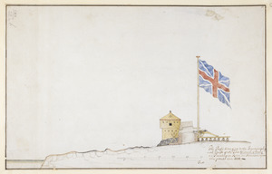
The Profil belonging to the Iconographycal Draft of the Fort William & Mary on Piscataqua River in America
352.
The United States of America laid down from the best authorities, agreeable to the Peace of 1783
353.
Plan of the French and rebells sieg[e] of Savannah in Georgia, in South [sic] America, deffend : t[h]rough the Br: Gen: August...
354.
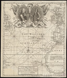
A new map or chart of the Western or Atlantic Ocean, with part of Europe Africa & America : showing the course of galleons,...
355.
The United States of America laid down from the best authorities, agreeable to the peace of 1783
356.
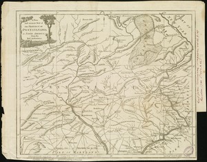
A new and accurate map of the province of Pennsylvania in North America, from the best authorities
357.
Amplissimae regionis Mississipi seu provinciae Ludovicianae â R.P. Ludovico Hennepin Francisc. Miss. in America septentrionali...
358.
Amplissimae regionis Mississipi seu Provinciae Ludovicianae â R.P. Ludovico Hennepin Francisc Miss in America Septentrionali...
359.
To his excellency General Washington, commander in chief of the armies of the United States of America : this plan of the...
360.
Mappa geographica Americae Septentrionalis ad emendatiora exemplaria adhuc edita jussu Acad. Reg. Scient. et eleg. litt. descripta
‹ Prev
Next ›
1
2
…
14
15
16
17
18
19
20
21
22
…
206
207


![Plan of the French and rebells sieg[e] of Savannah in Georgia, in South [sic] America, deffend](https://bpldcassets.blob.core.windows.net/derivatives/images/commonwealth:q524nc699/image_thumbnail_300.jpg)