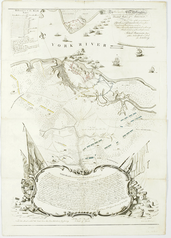
To His Excellency Genl. Washington, Commander in Chief of the armies of the United States of America : this plan of the investment of York and Gloucester has been surveyed and laid down, and is most humbly dedicated by His Excellency's obedient servant
This map is also available in American Revolutionary Geographies Online (ARGO), a collections portal especially built for material relating to the American Revolutionary War Era. Visit ARGO to learn more about this item and explore the historical geography of North America in the late eighteenth century.
Item Information
- Title:
- To His Excellency Genl. Washington, Commander in Chief of the armies of the United States of America : this plan of the investment of York and Gloucester has been surveyed and laid down, and is most humbly dedicated by His Excellency's obedient servant
- Title (alt.):
-
Plan of the investment of York and Gloucester
- Description:
-
Shows British and American troop positions, British defenses, including those on Gloucester Point, fields of fire, the first and second parallels, the headquarters of generals Washington and Rochambeau, the quarters of generals Nelson, Lincoln, Lafayette, Knox, Steuben, Clinton, and various French officers, ships in the York River, and "The Field where the British laid down their Arms." Also shows "Moore's House," vegetation and relief. Includes "References to the British Lines" with illustrations of ships and "Explanation" of the American and French siege operations. --cf. LC Maps of North America, 1750-1789.
- Cartographer:
- Bauman, Sebastian
- Engraver:
- Scot, Robert, 1745-1823
- Name on Item:
-
Sebastn. Bauman, major of the New York or 2nd Regt of Artillery
- Date:
-
1782
- Format:
-
Maps/Atlases
- Location:
- New-York Historical Society
- Collection (local):
-
New-York Historical Society Collection
- Subjects:
-
Yorktown (Va.)--History--Siege, 1781--Maps--Early works to 1800
Yorktown (Va.)--Maps--Early works to 1800
Virginia--Maps--Early works to 1800
York River (Va.)--Maps--Early works to 1800
Virginia--History--Revolution, 1775-1783--Maps--Early works to 1800
United States--History--Revolution, 1775-1783--Maps
- Places:
-
VirginiaYork (county)Yorktown
- Extent:
- 1 map : hand colored ; 47 x 45 cm on sheet 66 x 48 cm.
- Terms of Use:
-
No known copyright restrictions.
No known restrictions on use.
- Publisher:
-
[Philadelphia] :
R. Scot Sculp. Philad.
- Scale:
-
Scale [ca. 1:14,400]
- Language:
-
English
- Catalog Record:
-
https://library.nyu.edu/persistent/lcn/nyu_aleph004267387?institution=NYU&persistent
- Notes:
-
"This plan was taken between the 22nd & 28th of October, 1781."-- cartouche at foot.
"Note. The Land within the doted [sic] lines has been laid down by survey."
Relief shown by hachures.
- Notes (citation):
-
LC Maps of North America, 1750-1789, 1471
- Identifier:
-
84388d_InvestmentYorkGloucester1782_Bauman