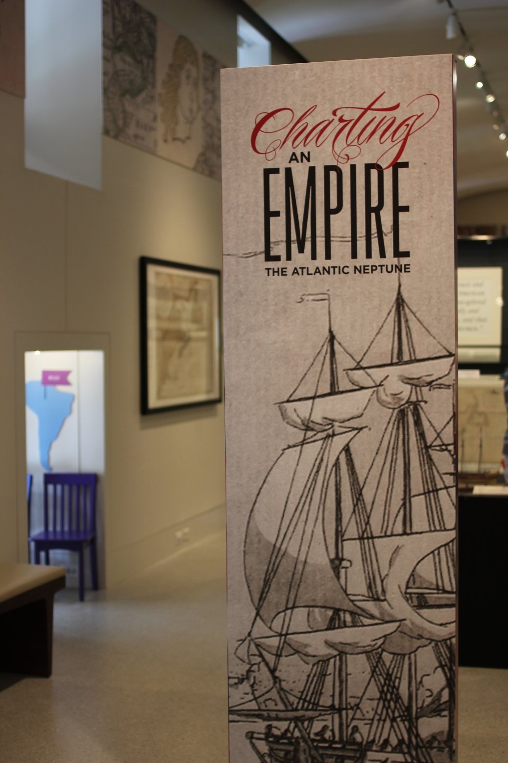
Introduction
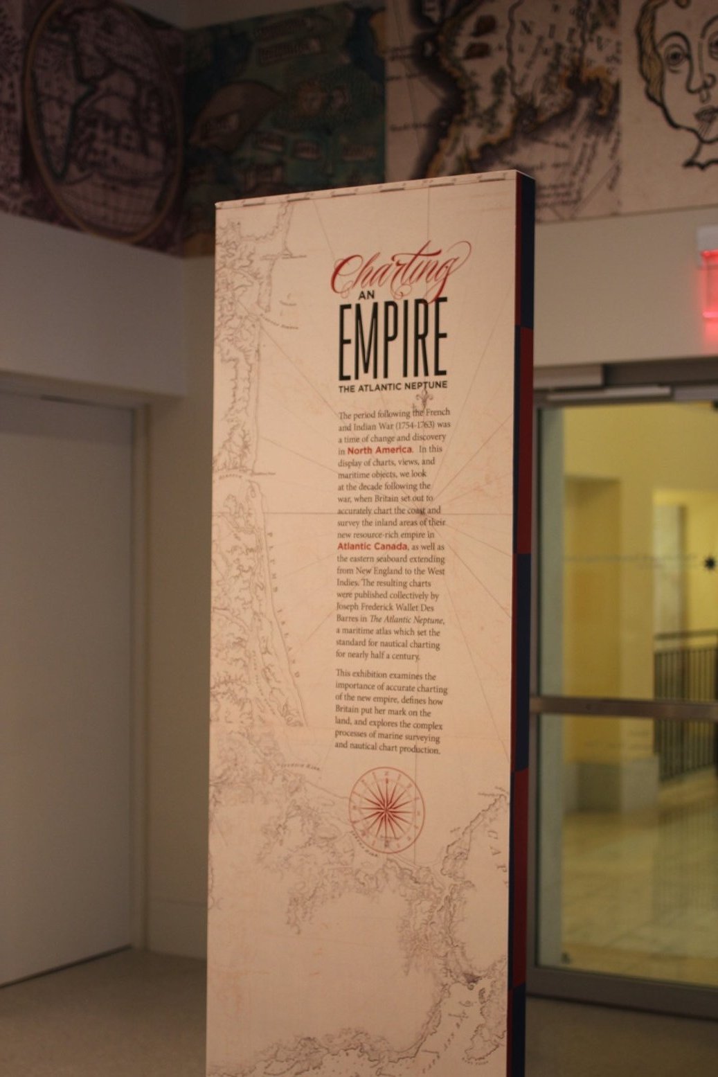
The period following the French and Indian War (1754-1763) was a time of change and discovery in North America. In this display of charts, views, and maritime objects, we look at the decade following the war, when Britain set out to accurately chart the coast and survey the inland areas of their new resource-rich empire in Atlantic Canada, as well as the eastern seaboard extending from New England to the West Indies. The resulting charts were published collectively by Joseph Frederick Wallet Des Barres in The Atlantic Neptune, a maritime atlas which set the standard for nautical charting for nearly half a century.
Using nearly 30 items, including nautical charts, navigational instruments and ship models, dating from the 18th century to the present, this exhibition examines the importance of accurate charting of the new empire, defines how Britain put her mark on the land, and explores the complex processes of marine surveying and nautical chart production.
Part one of the exhibition, showing May 1st through July 27, will focus geographically on Atlantic Canada. In this section we examine the surveys of engineers Samuel Holland and J.F.W. Des Barres, which were then published as charts in The Atlantic Neptune. Canada’s economic importance to Britain is explained, as is the need for accurate charts of the region. Charts of the eastern seaboard from New England to the West Indies are the focus of part two, showing from August 1 through November 3. Maps and views of major port cities along the coast will be included, as well as inland areas. These charts were produced just in time for use by the British Navy, as the American Revolutionary War was beginning.
The development of nautical chart making is described throughout the exhibition, and is illustrated in a number of examples. We will also consider the artistic marvel that is The Atlantic Neptune, and discuss the processes involved in the production of such an atlas, from surveying to engraving.
1. North American Coast
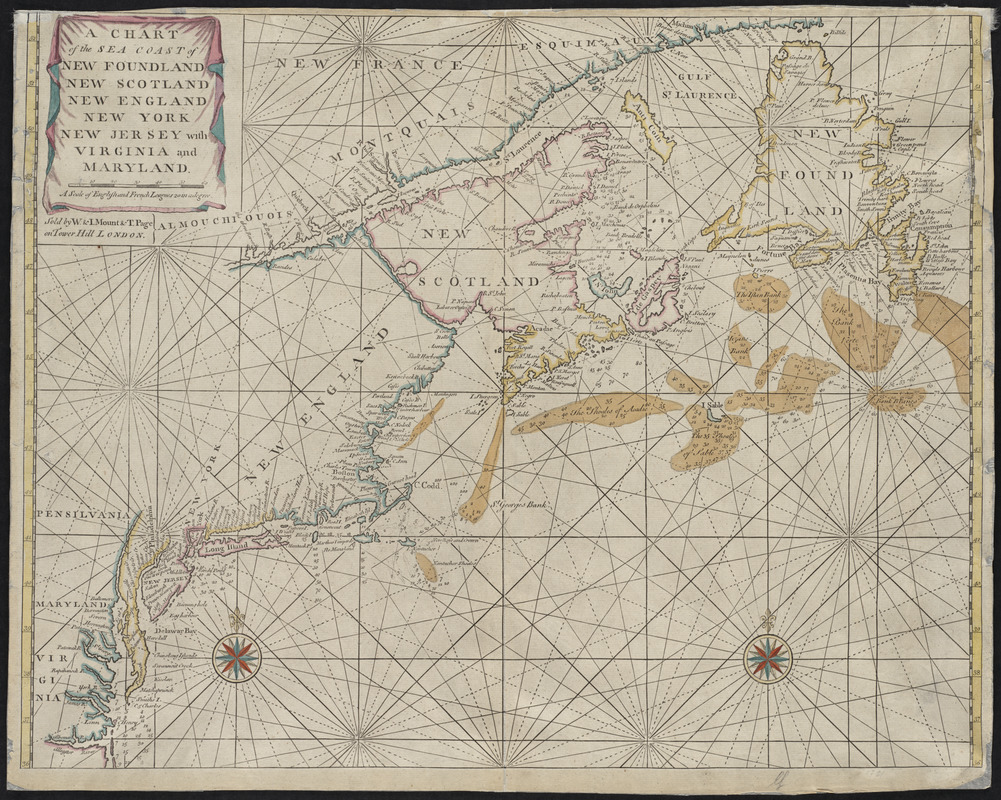
John Thornton
A chart of the sea coast of New Foundland, New Scotland, New England, New York, New Jersey, with Virginia and Maryland
[after 1748].
First published in 1689, John Thornton’s chart of the north Atlantic seacoast illustrates the type of nautical charts available to navigators in the Fourth Book of the English Pilot, which was the standard resource for mariners at the time. The charts were flawed with numerous inaccuracies, and did not provide enough detail to have been truly beneficial to those sailing close to the shore. Many ships were damaged off the coasts of Newfoundland and Nova Scotia because accurate and comprehensive charts of the area were not available to those navigating to Canada from England.
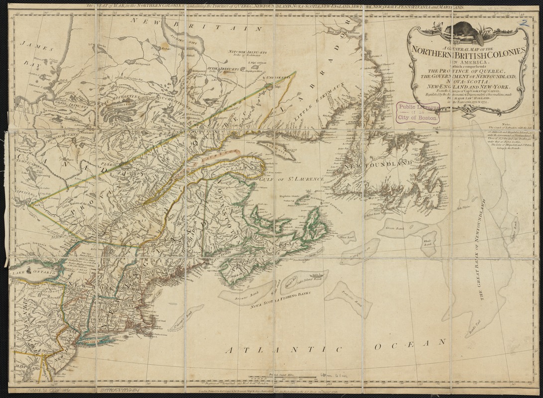
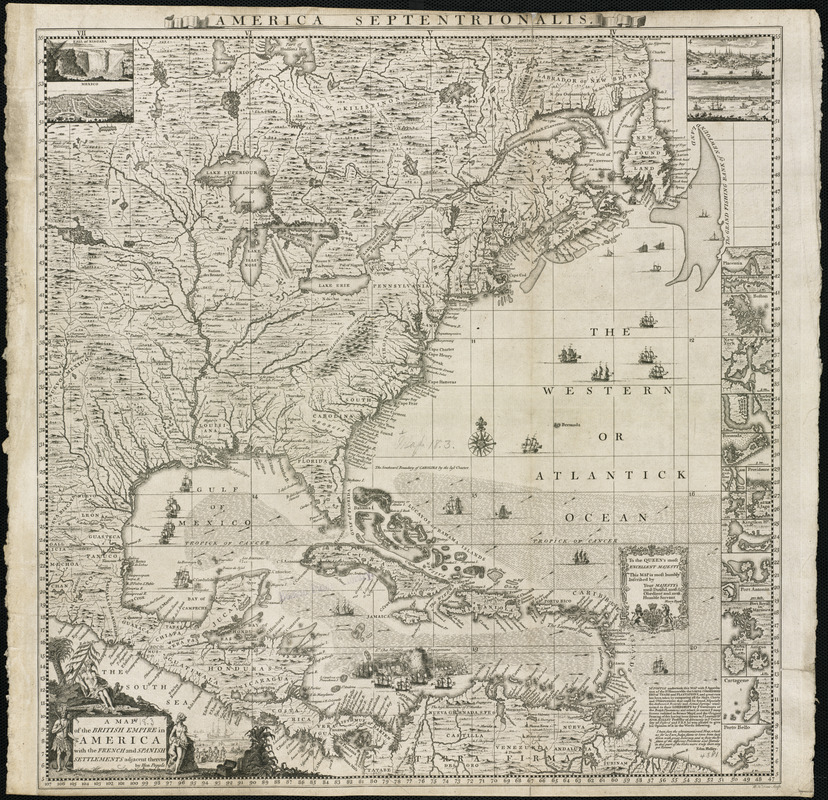
Robert Sayer and John Bennett
A general map of the northern British Colonies in America which comprehends the province of Quebec, the government of Newfoundland, Nova-Scotia, New-England and New-York
1776.
Published by a prominent London firm, this map illustrates the extent of the British colonies in northern North America at the beginning of the American Revolutionary War. Britain was keenly interested in maintaining control of this region because the exportation of furs and cod fish generated sizable income for merchants back in England. Profitable natural resources were abundant in Canada, as suggested by the placement of a North American beaver atop the cartouche, and the detailed depiction of the fishing banks off the coast of Newfoundland and Nova Scotia.
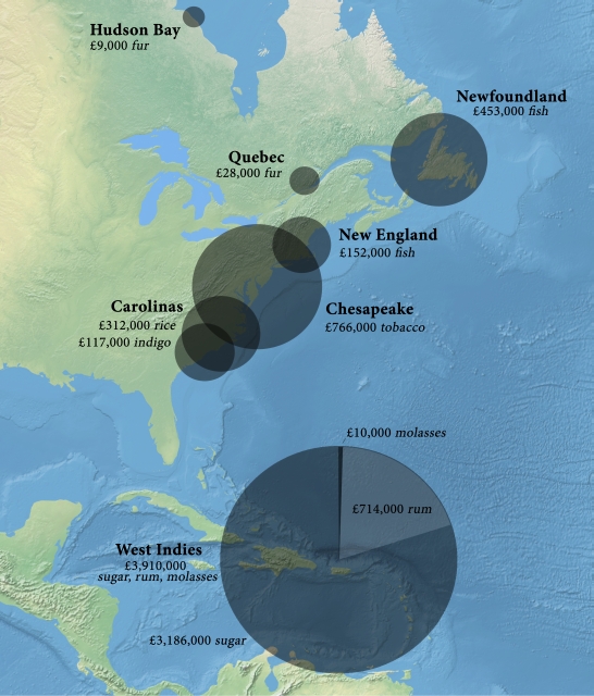
Stephen Hornsby
“Staple Regions in North America and the Caribbean, 1764-1775,” from British Atlantic, American Frontier
2005.
This modern graphic illustrates how profitable the export trade of natural resources from North America was for British merchants in the decade before the American Revolutionary War. Furs from Hudson Bay and Québec generated £37,000 in 1770, whereas the incredibly productive Newfoundland cod fishery generated over £450,000 annually from 1764-1774. Surpassed in worth only by sugar and tobacco, the North Atlantic cod fishery was critical to a flourishing trans-Atlantic trade. Consequently, the British Navy was tasked with protecting the English fisheries from potential commercial competitors.
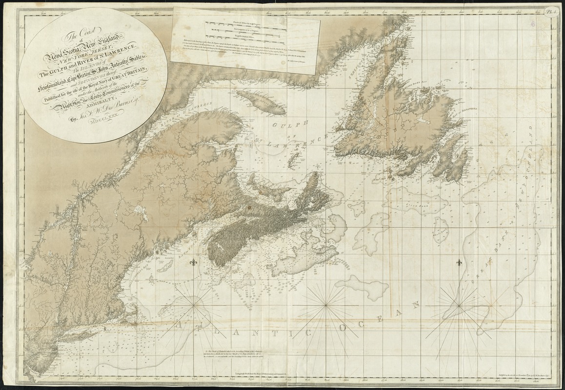
J.F.W. Des Barres
The coast of Nova Scotia, New England, New-York, Jersey, the Gulph and River of St. Lawrence : the islands of Newfoundland, Cape Breton, St. John, Antecosty, Sable &c. and soundings thereof …
1780.
This chart of the northeast coast of North America is the most comprehensive map in The Atlantic Neptune, covering the largest geographic area. It was produced using the latest scientific technology available for marine surveying in the second half of the 18th century, resulting in a chart that remains remarkably accurate for being over two hundred years old. Illustrating the northern district of Britain’s North American empire, Des Barres’ chart bears a striking resemblance to the modern Canadian Hydrographic Service chart of the same area.
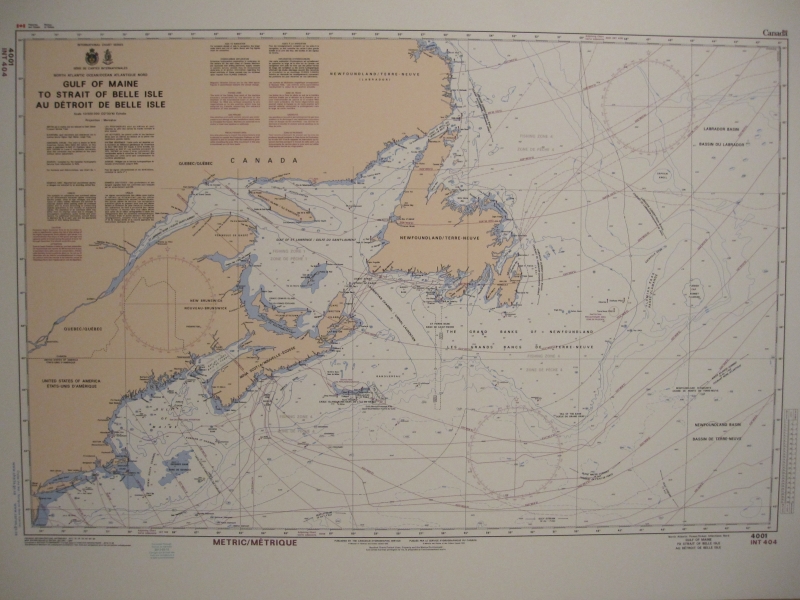
Canadian Hydrographic Service
Gulf of Maine to Strait of Belle Isle: au Détroit de Belle Isle
1995.
This modern chart is used by present-day mariners. When compared to Des Barres’ chart of the same area, one notices how similar the charts are in appearance. Because Des Barres utilized scientific surveying techniques, his charts closely resemble modern ones of the area. Although originally produced in 1995, this chart contains updates, referred to as mariner’s notices, to February 2013. Today, navigators receive timely marine safety information for the correction of charts on a constant basis, rather than having to wait for publications such as The Atlantic Neptune to become available.
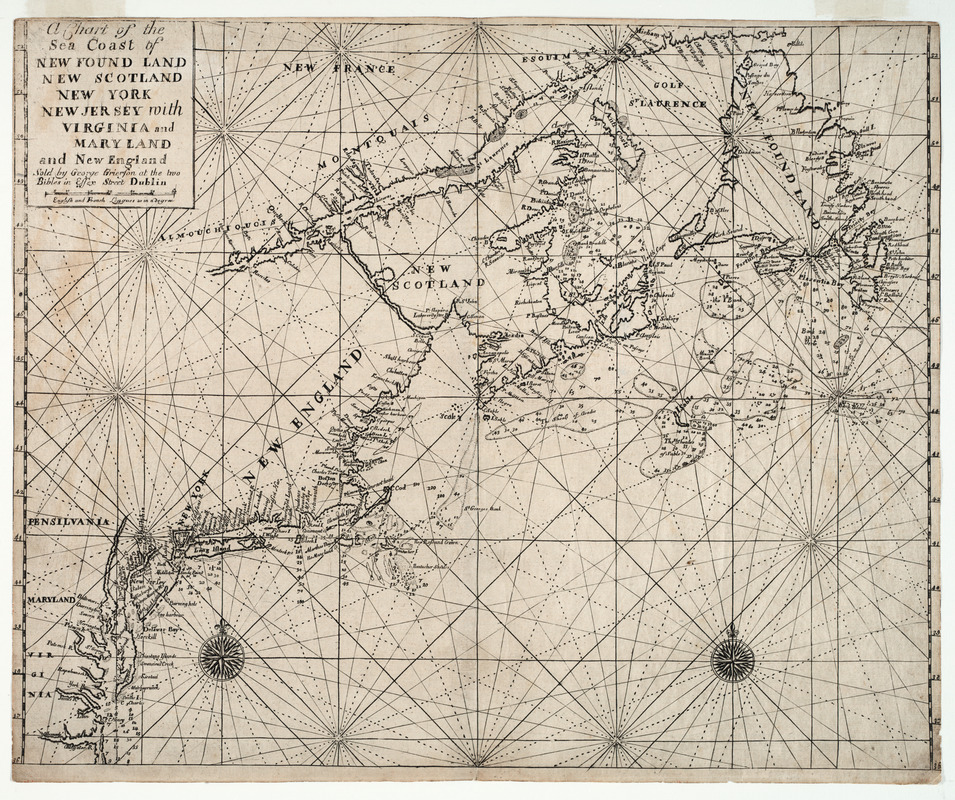
George Grierson
A Chart of the Sea Coast of New Found Land, New Scotland, New York, New Jersey, with Virginia and Maryland and New England
1749.
Published in 1749, George Grierson’s chart of the North American seacoast illustrates the type of nautical charts available to navigators in the Fourth Book of The English Pilot (London), which was the standard resource for mariners at the time. Grierson’s charts, published in Dublin, were copied from original examples in The English Pilot; however, they were flawed with numerous inaccuracies and were made with low quality materials. With the eventual production of the accurate and detailed charts in The Atlantic Neptune, navigators could sail to the colonies with a heightened sense of safety.
Henry Popple
A Map of the British Empire in America with the French and Spanish Settlements Adjacent Thereto
1733.
By the time this map illustrating the extent of the British Empire was produced in 1733, colonial merchants and planters had developed new staple economies throughout the eastern seaboard. Forest products from Maine and New Hampshire, fish from New England, tobacco from the Chesapeake region, and rice from South Carolina transformed the colonies, creating self-sustaining economies that gradually became less reliant on trans-Atlantic trade with England. Permanent settlements were established in these regions, and with them a new economic, political and social structure. As these colonies began to trade more with each other, accurate charts of the North American coast became increasingly important.
2. Atlantic Canada
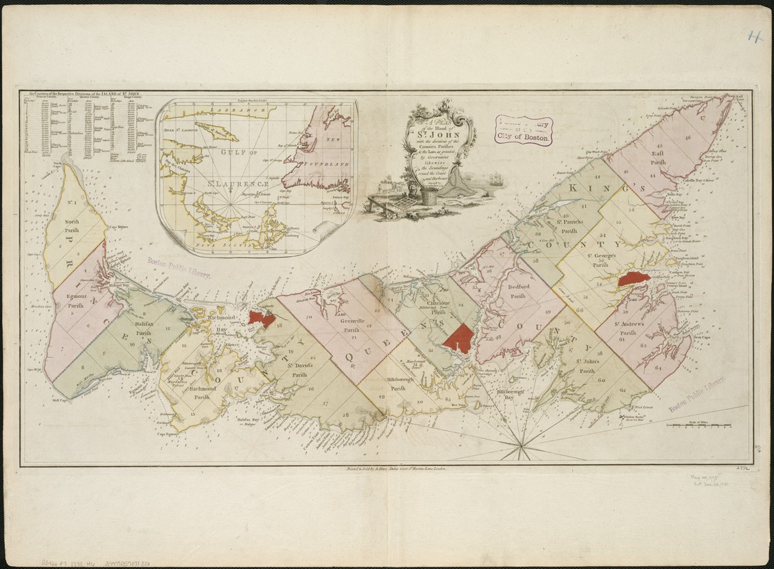
Samuel Holland
A Plan of the Island of St. John with the Divisions of the Counties, Parishes, & the Lots as Granted by Government, Likewise the Soundings Round the Coast and Harbours
1775.
A major producer of the surveys that developed into The Atlantic Neptune was Capt. Samuel Holland, Surveyor General for the Northern District. Holland’s survey of St. John’s Island – modern-day Prince Edward Island – was his first task performed for The General Survey of North America, where systematic surveys were executed according to the latest scientific principles. With explicit instructions from the Board of Trade, Holland divided the island into a grid-system of counties, parishes, and townships of uniform size. French and indigenous place names were changed to commemorate British royal figures, expressing the Empire’s power in the region.
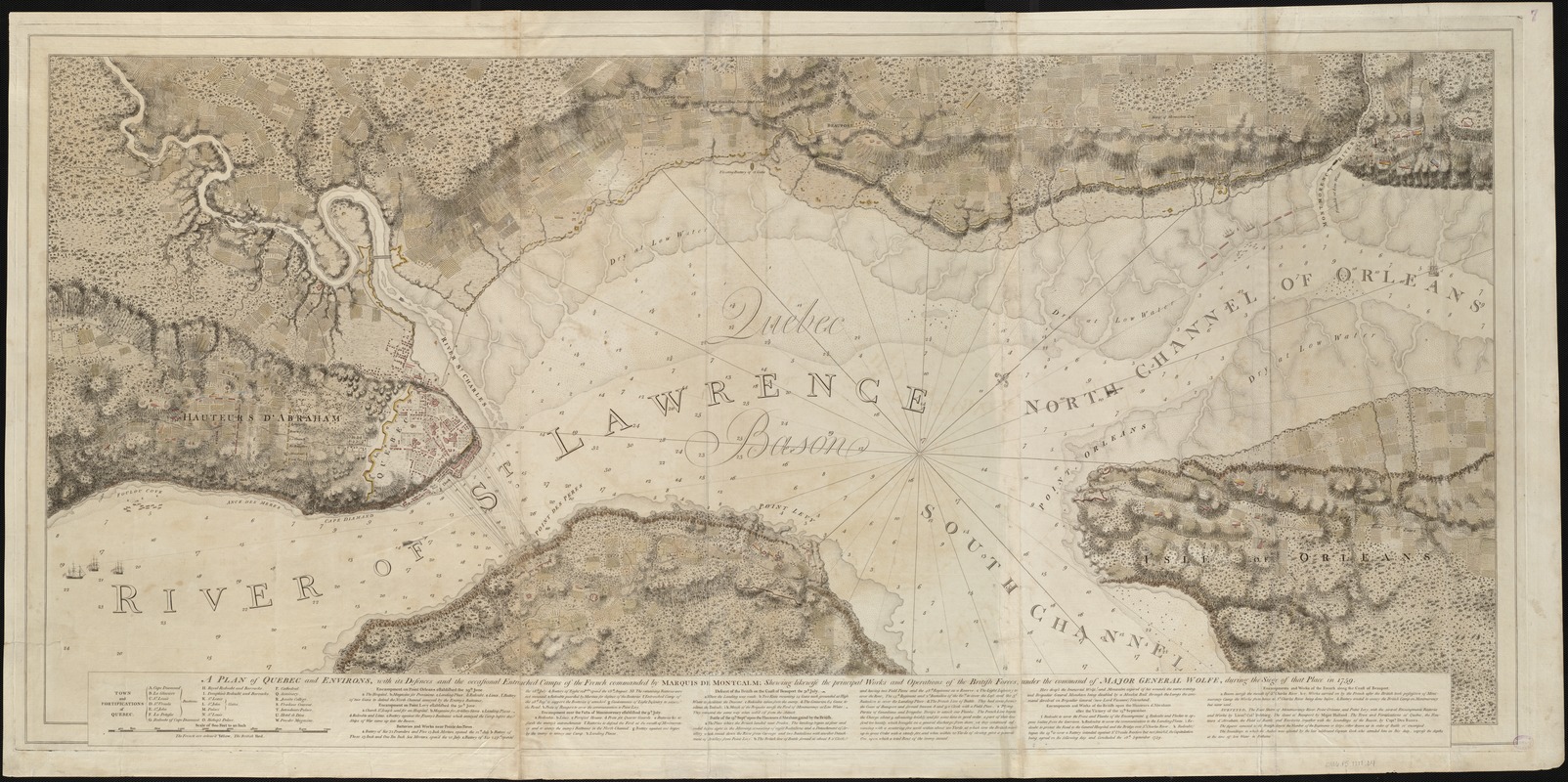
J.F.W. Des Barres
A plan of Quebec and environs, with its defences and the occasional entrenched camps of the French commanded by Marquis de Montcalm …
1777.
In addition to Ticonderoga and Louisbourg, Québec City was the other major French stronghold in northeastern North America. Its capture was critical to Britain’s mission during the French and Indian War. This map delineates the positions of British and French troops during the 1759 siege of the city. The original surveys for this plan were prepared by Samuel Holland and J.F.W. Des Barres after the capture of Québec. Des Barres surveyed the battlefield and fortifications on the Plains of Abraham and took soundings in the harbor. A combination of scientific measurements and artistic skill, this plan exemplifies the care taken with each chart in The Atlantic Neptune.
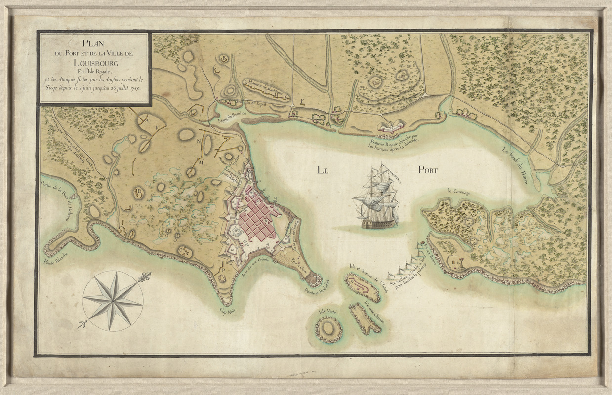
Plan du Port et de la Ville de Louisbourg en l’Isle Royale, et des Attaques Faites par les Anglois Pendant le Siége Dépuis le 8 Juin Jusqu’au 26 Juillet 1758
[1758].
Courtesy Richard H. Brown.
During the early 18th century, Île Royale – present-day Cape Breton Island – was home to a group of displaced French settlers from Newfoundland. A fortress was constructed in 1713 at Louisbourg to protect French Canada from the enemy. The British laid siege to Louisbourg in 1758 during the French and Indian War. Prepared by a French cartographer, this map depicts the city and fortress during this six-week struggle. With a decisive British victory, the island was ceded to Britain by the Treaty of Paris in 1763, and renamed Cape Breton.
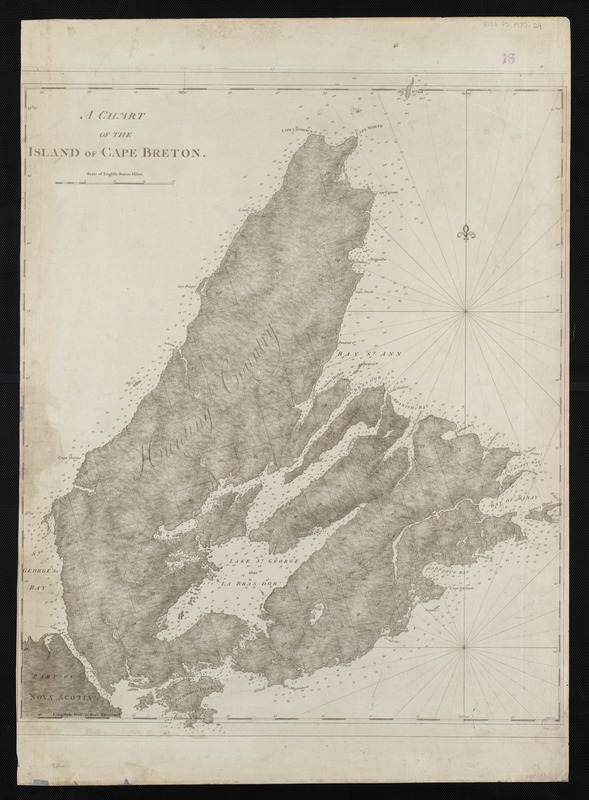
J.F.W. Des Barres
A Chart of the Island of Cape Breton
1781.
Samuel Holland’s topographic surveys and Des Barres’ hydrographic soundings appear on this chart of Cape Breton Island, which was included in The Atlantic Neptune. Since the British knew relatively little about the interior of the island, surveying proved to be more difficult for Holland than on St. John’s Island. The northwest region of the island was simply referred to as “Hunting Country.” As on St. John Island, Holland divided the land and named places in a similar manner. However, because English royal names never became part of the local vernacular, these place names reverted to French, or were named anew by subsequent Scottish settlers.
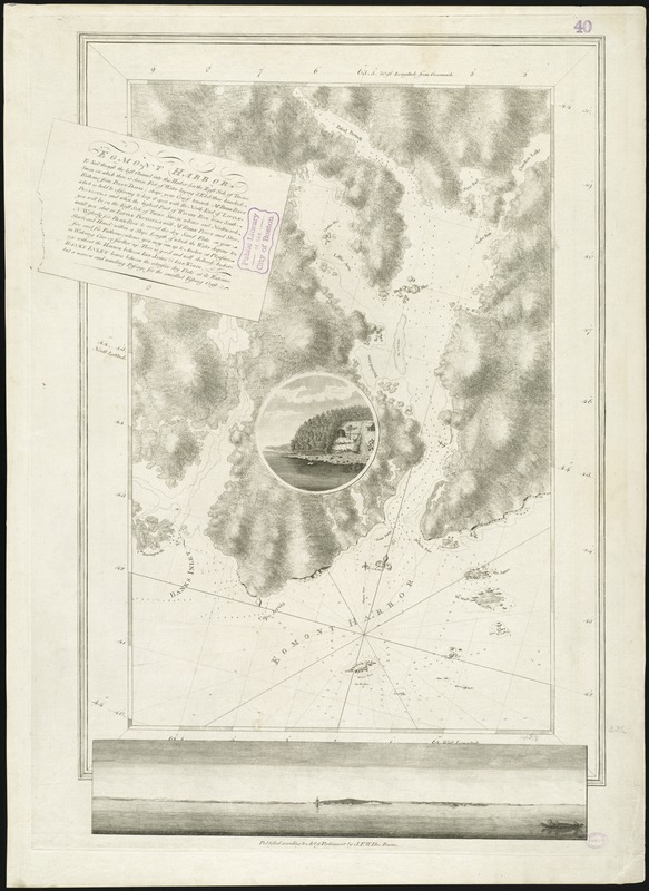
J.F.W. Des Barres
Egmont Harbor
1777.
Des Barres, a Swiss-born army engineer and colleague of Samuel Holland, was tasked with surveying the coasts of Nova Scotia in 1764. This chart of Egmont Harbor (modern-day Jeddore Harbour, northeast of Halifax), is a fine example of the three types of visuals found throughout The Atlantic Neptune, as it combines a nautical chart with a coastal profile, and an illustrative vignette. Des Barres’ thorough work of gathering soundings (measurements of depths) is seen here, and throughout the Neptune. These measurements, gathered according to the latest scientific standards, along with numerous sailing directions, helped navigators avoid underwater dangers near the coast.
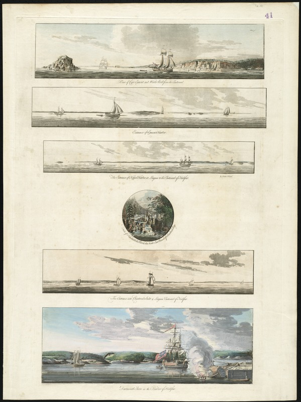
J.F.W. Des Barres
[Views in the Vicinity of Halifax]
1777.
Individual sheets of coastal views appear throughout The Atlantic Neptune. Landfall and headland views, like those displayed here, were intended to give mariners a sea-view of the harbor and coastline and were used in conjunction with charts of the corresponding area. By comparison, the central, circular view of the Falls of Hinchinbroke River … was not intended for navigational use like coastal profiles, but was simply an artistic representation of an inland landmark, named in honor of a patron. The lower view of Halifax Harbour is another example of an artistic depiction of a port, of which numerous examples can be found throughout the Neptune.
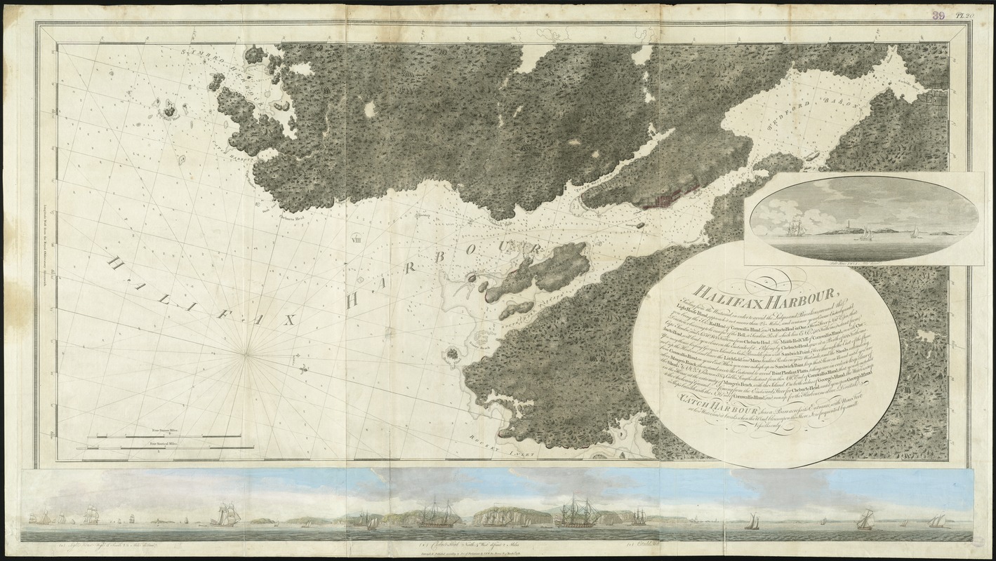
J.F.W. Des Barres
[Coastal View of Chebucto Head]
1777.
This colorful and beautifully executed panoramic view depicts the coastal region near Halifax, and in its original form accompanies a large chart of Halifax Harbour in The Atlantic Neptune. Designed to provide navigators with an accurate view of the shoreline and Harbour, this coastal profile extends from the Sambro Island Lighthouse, past Chebucto Head, north to the inner Harbour of Halifax. Included is a distant view of the citadel in Halifax, a fortress originally built by the British in 1749 to protect the town from the French settlers in Louisbourg.
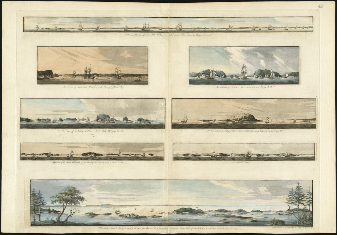
J.F.W. Des Barres
[Eight Views of the East of Nova Scotia]
1777.
This grouping of eight headland views paints a striking picture of the Nova Scotia coast, east of Halifax. Covering a geographic area from Beaver Harbour northeast to Milford Haven (a distance of 160 miles), these coastal profiles served a utilitarian purpose for mariners navigating the complicated Nova Scotia coastline. Artistic elements such as foreboding skies and ships mooring in the port were added for aesthetic appeal; however, the coastal representations themselves were provided for navigational purposes. These views are a major advance over the earlier, unsophisticated headland views available to navigators in such works as The English Pilot.
3. Eastern Seaboard of Colonial America
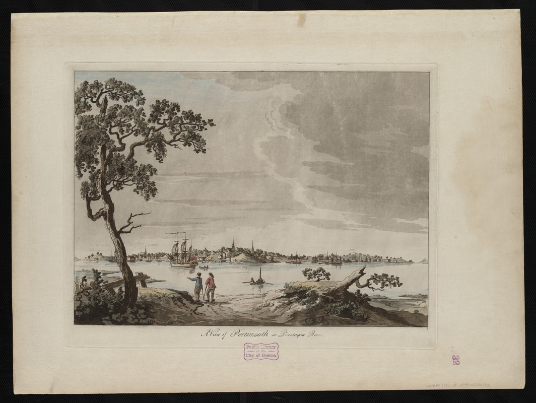
The heavily forested areas of New Hampshire contributed to a thriving lumber and shipbuilding business on the Piscataqua River. As seen in this detail view of Portsmouth, N.H., the city grew into a bustling port after the French and Indian War, and was a key supplier to the mast trade and the shipbuilding industry on the eastern seaboard. The town also exported fish and other provisions to sugar plantations in the Caribbean. Samuel Holland, Surveyor General for the Northern District, relocated from Québec to Portsmouth in 1770 to begin the survey of New England, a task that would take the next five years to complete.
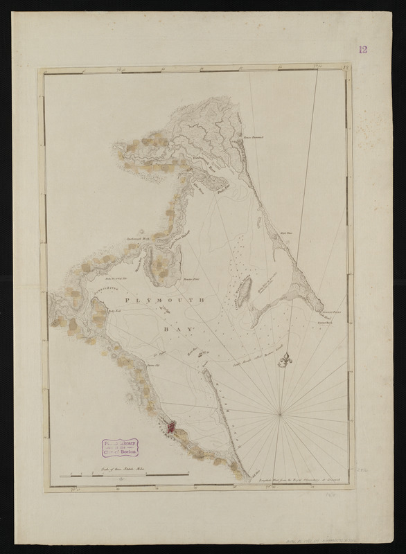
J.F.W. Des Barres
Chart of Plymouth Bay
1781.
The chief product produced in colonial New England was dried cod. As a result, permanent, residential fishing settlements were established throughout New England in the 17th century, including one at Plymouth, Massachusetts. This 1781 chart illustrates the homesteads, roads, and topography in the vicinity of Plymouth. By the 1770s, the majority of the lower-quality dried cod produced in New England’s offshore banks was being exported to the Caribbean, and served as a main food source for slaves working on sugar plantations. This cost-saving measure, coupled with profits from quality cod exported to Iberia, resulted in an abundance of wealth for New England fish merchants.
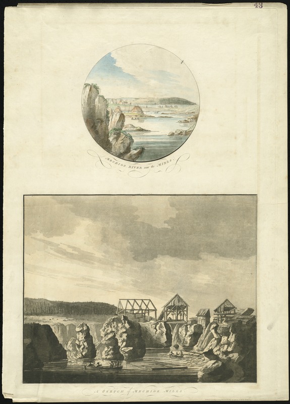
J.F.W. Des Barres
Mechios River Near the Mills; A Sketch of Mechios Mills
1777.
This engraving of the Machias area in the Boston Public Library’s Atlantic Neptune collection was struck from the plate held by the Massachusetts Historical Society. By 1770, several mills were built on the Machias River, as the region was ideal for producing lumber. Conflict erupted between the residents and the British Navy in 1775, and a number of sailors lost their lives. In early August of 1777, mere days after this image was engraved, the British attacked the town of Machias, and burned the settlement in retaliation for the uprising two years earlier.
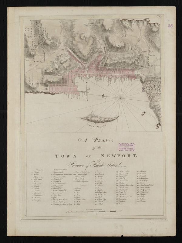
J.F.W. Des Barres
A Plan of the Town of Newport in the Province of Rhode Island
1781.
Unique among colonial settlements, Newport, R.I. embraced the notions of religious tolerance and social service, and became one of the five largest cities in British North America. An economy built upon shipbuilding, the maritime trades, and agriculture allowed the town to grow into an important harbor where raw materials entered and finished products were exported. This 1781 chart lists the numerous places of interest in the town, including wharves, public buildings, places of worship and streets. Newport merchants increasingly smuggled goods in and out of Narragansett Bay to evade paying taxes, and this lawlessness led to the stationing of the ship Gaspee II in the Bay, to monitor the flow of goods.
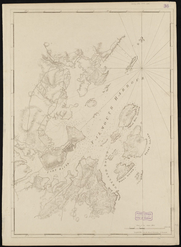
J.F.W. Des Barres
Falmouth Harbour
1777 [1st state]
The town of Falmouth (present-day Portland, Me.) was the most important supplier of forest products in the British Empire before the American Revolutionary War. Falmouth’s large harbor was well protected, was easily defendable and was adjacent to vast forests of white pine, all of which contributed to the town’s commercial success. This 1777 chart of the region is the first state, or edition of the map, and it details the harbor islands, as well as inland topography, roads and settlements. By the dawn of the Revolutionary War, Britain was dependent on wood produced in the colonies, and Falmouth was a key component of the extensive lumber trade.
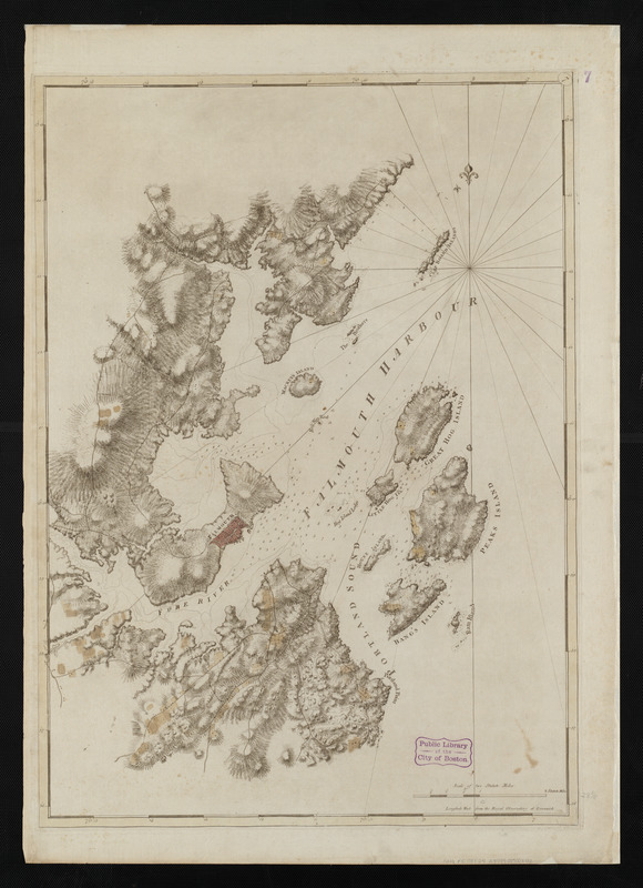
J.F.W. Des Barres
Falmouth Harbour
1777 [2nd state]
Des Barres’ second state of the Falmouth Harbour chart is displayed here. This state differs from the first with the addition of dark relief shading to emphasize the topography, and the addition of soundings (measurements of depths) in the harbor. The tall pines which grew in the Maine forest were perfect for fashioning into ships’ masts, and numerous sawmills were established around the region. Inland lumber was transported to the docks via “mast-roads,” and roads leading to the port are illustrated in this second edition. Ultimately, Falmouth was destroyed by the British in October 1775, in an act of retaliation for a deadly uprising by the colonists at Machias, Maine, four months earlier.
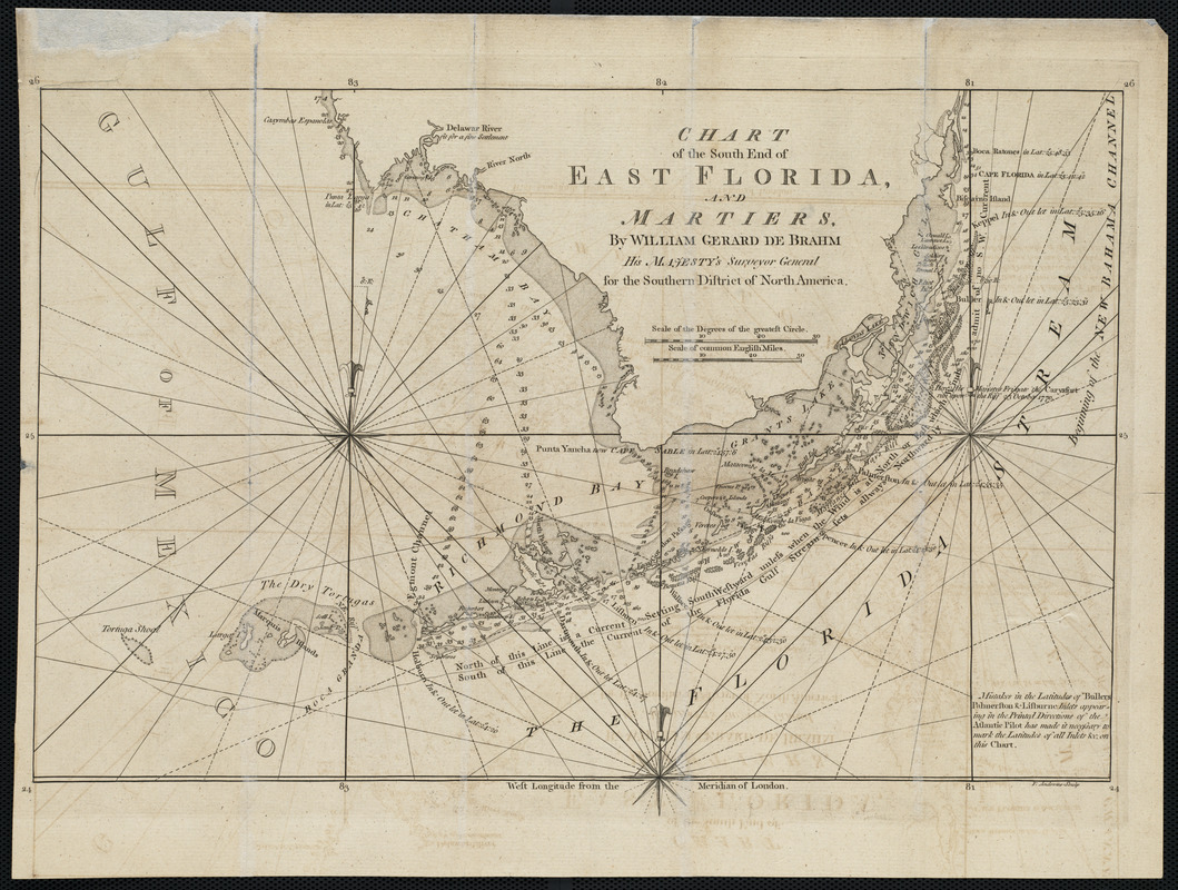
John Gerar William De Brahm
Chart of the South End of East Florida, and Martiers
1772.
De Brahm concentrated his surveying efforts on the east coast of Florida, from St. Augustine south to the Keys. This chart of the southern tip of east Florida was included in the English edition of The Atlantic Pilot, along with a chart of the Gulf Stream and a map of the ancient Florida peninsula. De Brahm’s meticulous hydrographic survey work is evident in this chart, with its numerous soundings, outlines of shoals, and inclusion of anchoring places. These surveys were eventually used by Des Barres, and the information was included on the charts which make up The Atlantic Neptune.
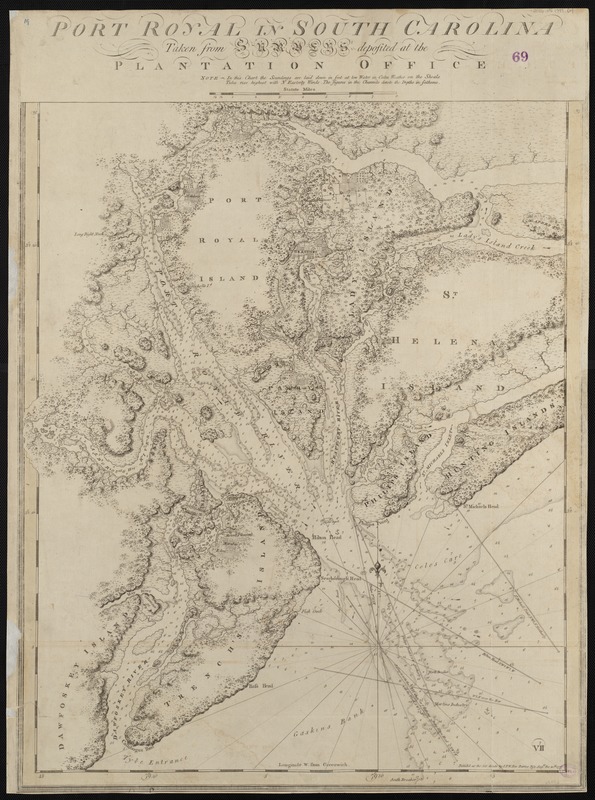
J.F.W. Des Barres
Port Royal in South Carolina
1777.
The staple industry in South Carolina was rice, produced on plantations in the coastal region known as the Low Country. This highly-detailed 1777 chart of the Port Royal region illustrates an area where there were many rice plantations, which relied on imported African slaves to work the fields until after the American Revolutionary War. By the 1770s, rice accounted for over 50 percent of all exports from the colony. Due to the success of the rice export industry, an indigenous planter class rose to power over time, and these colonists would eventually join with others along the eastern seaboard to defy British dominance.
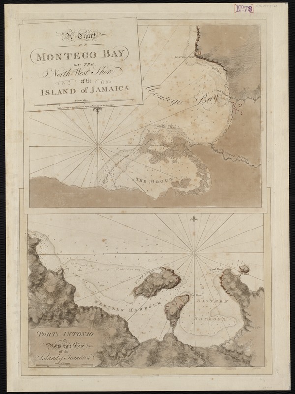
J.F.W. Des Barres
A Chart of Montego Bay on the North West Shore of the Island of Jamaica
1780.
The most profitable commodity produced in the colonies was sugar, and the plantations of Jamaica created a vast amount of wealth for British merchants. Jamaica became the center of the Caribbean sugar trade by the 18th century; however, unlike the mainland colonies, the island never became self-sufficient – it existed only for the production of the crop. This 1780 chart of Montego Bay and Port Antonio shows two areas of the island that were dedicated to the export of raw sugar. Safe navigation of these ports was essential to the continuation of the sugar trade, and Britain made a point to conduct hydrographic surveys of the area, as they did on the mainland.
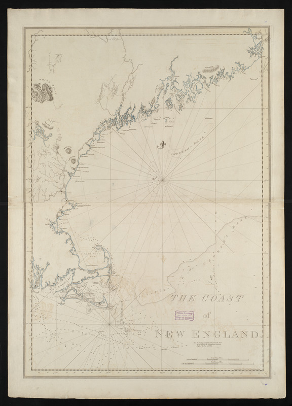
J.F.W. Des Barres
The Coast of New England
1781.
This chart of the Atlantic coast of New England from northern Maine to Narragansett Bay appeared in the third volume of The Atlantic Neptune. It was produced using the latest scientific technology available for marine surveying in the second half of the 18th century, resulting in a chart that remains remarkably accurate for being over two hundred years old. Produced from surveys executed under the supervision of Samuel Holland, this chart bears a striking resemblance to the modern United Kingdom Hydrographic Office chart of the same area.
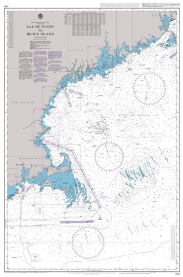
United Kingdom Hydrographic Office
Bay of Fundy to Block Island
1887. Updated to 2013.
This modern chart is used by present-day mariners. When compared to Des Barres’ chart of the same area, one notices how similar the charts are in appearance. Because Des Barres utilized scientific surveying techniques, his charts closely resemble modern ones of the area. Although originally produced in 1887, this chart contains updates, referred to as mariner’s notices, to March 2013. Today, navigators receive timely marine safety information for the correction of charts on a constant basis, rather than having to wait for publications such as The Atlantic Neptune to become available.
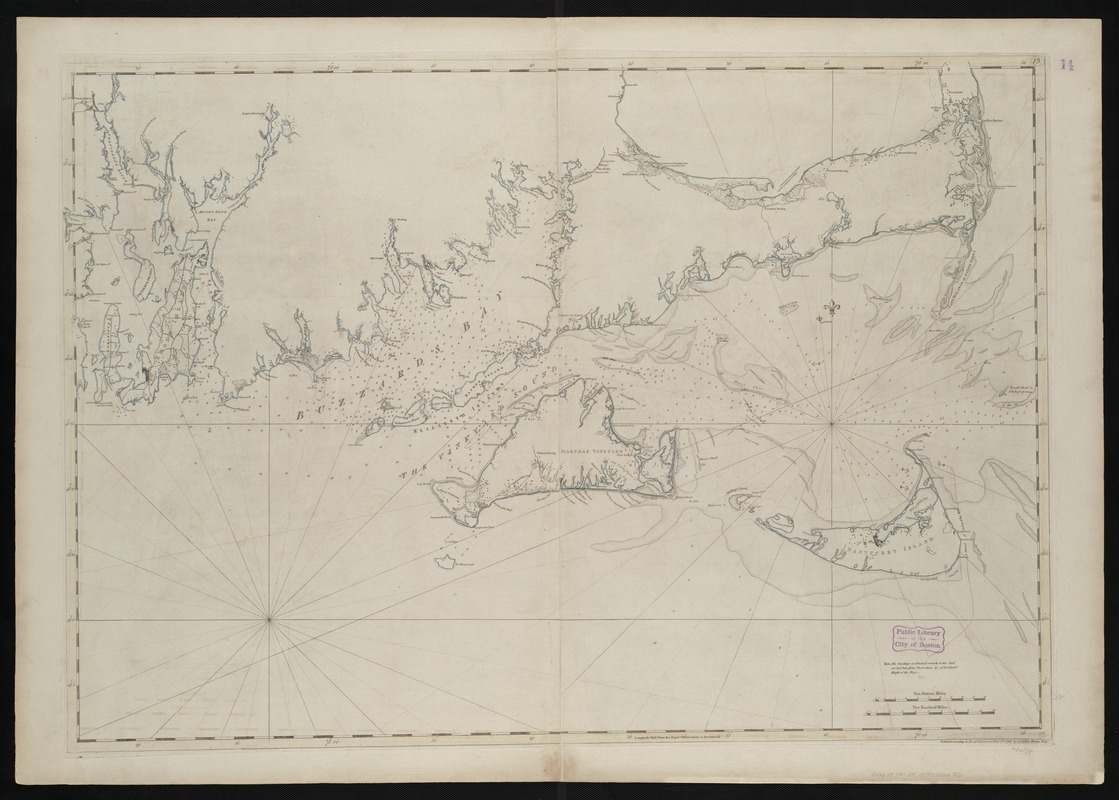
J.F.W. Des Barres
[Coast of New England from Chatham Harbor to Narragansett Bay]
1781.
This chart of the southern coasts of Massachusetts and Rhode Island is representative of the level of detail contained in the charts of The Atlantic Neptune. The surveys of this coastline began in 1774, and were performed by engineers working under the supervision of Samuel Holland. With the inclusion of numerous soundings, the chart is able to convey the depth of the sea at various places in a two-dimensional form. Modern nautical charts use the same placement of soundings along coastlines to inform navigators of underwater dangers. It was imperative for 18th century mariners to have such safety information, as navigation of intricate and unknown coasts could be perilous.
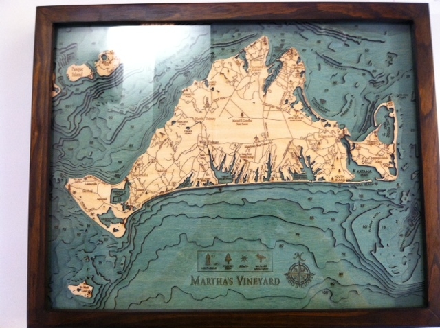
Below the Boat
Martha’s Vineyard
2012.
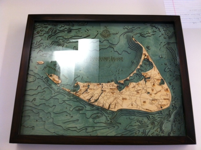
Below the Boat
Nantucket Island, Massachusetts
2012.
These modern, artistic wood charts of Martha’s Vineyard and Nantucket also illustrate the depth of the sea. These three-dimensional representations convey the same bathymetric (measurement of water depth at various places) information found on Des Barres’ chart of the area. The various layers of wood in these charts demonstrate how the ocean gradually gets deeper the further one travels from shore. Soundings and bathymetry illustrate what exists under the water’s surface. Although not used for navigational purposes, these works of art visually convey depth of the ocean floor in a way that is not only easily understandable, but also captivating.
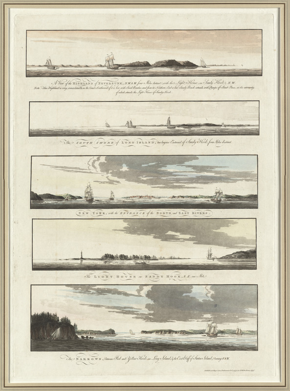
J.F.W. Des Barres
[Five views of New York and approaches]
1777.
Courtesy Richard H. Brown.
Individual sheets of coastal views appear throughout The Atlantic Neptune. Landfall and headland views, like those displayed here, were intended to give mariners a sea-view of the harbor and coastline, and were used in conjunction with charts of the corresponding area. Although not in order as one would approach them in real life, these scenes offer the viewer an 18th century glimpse of New York Harbor. These highly artistic depictions were sketched by artists who were part of the surveying crew, and represent a body of work that is not only utilitarian, but also beautiful.
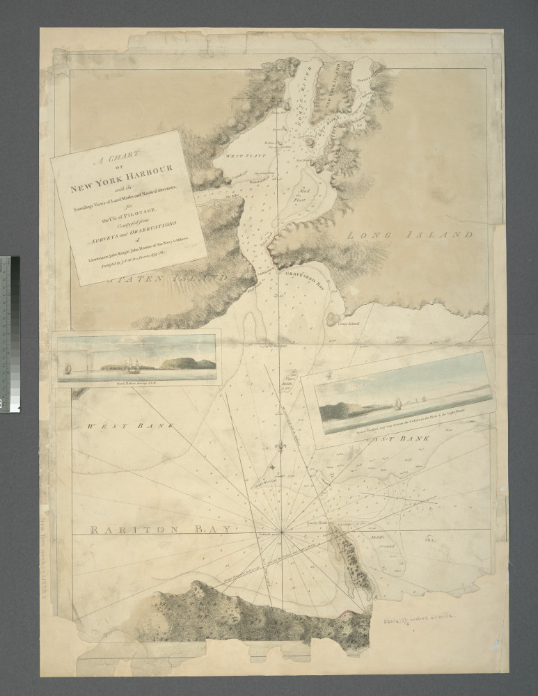
J.F.W. Des Barres
A Chart of New York Harbour: with the Soundings, Views of Land Marks and Nautical Directions for the Use of Pilotage
1779. Reproduction 2013.
Courtesy New York Public Library.
Des Barres’ chart of the harbor of New York differs vastly from the earlier chart by Mark Tiddeman. As this chart was produced using the latest scientific advances in marine surveying, the result is a document that allowed for safe navigation among the complicated shores of New York Harbor. In addition, the two coastal profiles included here illustrate landmarks that when seen and read with accompanying sailing instructions, would alert the navigator to set a particular course. Tiddeman’s chart was still in circulation when Des Barres published his chart of the same area; however, the advanced navigational conventions presented here superseded the earlier work.
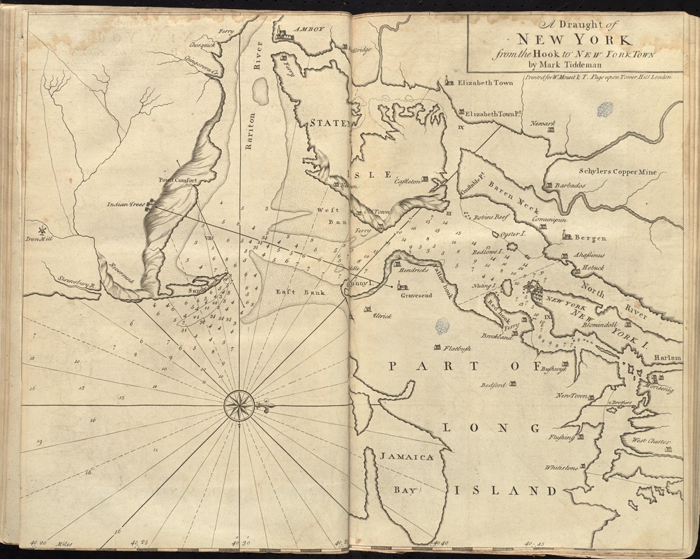
Mark Tiddeman
“A Draught of New York from the Hook to New York Town,” in The English Pilot: The Fourth Book
1737.
This chart of the entrance to New York was included in the 1737 edition of The English Pilot: The Fourth Book. Tiddeman’s chart served as the standard chart of the area for nearly fifty years, until the publication of The Atlantic Neptune. This chart includes rough depictions of topography along the coastline, in the form of hachures, or lines. These lines were intended to give the navigator a sense of height, such as cliffs or other tall landforms. Compared to the detailed and finely executed headland views of the same area in The Atlantic Neptune, Tiddeman’s version is crude, and less instructive.
4. The Atlantic Neptune
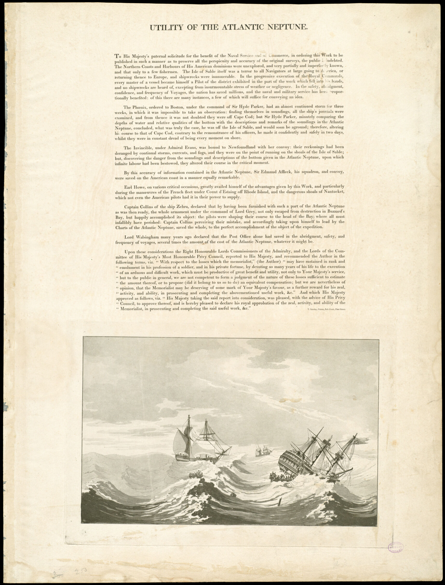
J.F.W. Des Barres
[Detail from “Utility of The Atlantic Neptune”]
1777.
This striking visual was included with the text of the "Utility of The Atlantic Neptune." A large British ship is sinking in rough seas while the crew escapes on lifeboats. This image was intended to give the reader a sense of the danger that navigators faced off the treacherous coast of Nova Scotia. Prior to the availability of the soundings and sailing directions in The Atlantic Neptune, numerous ships were lost as a result of the unknown underwater dangers that lay in the path of their voyage to North America.
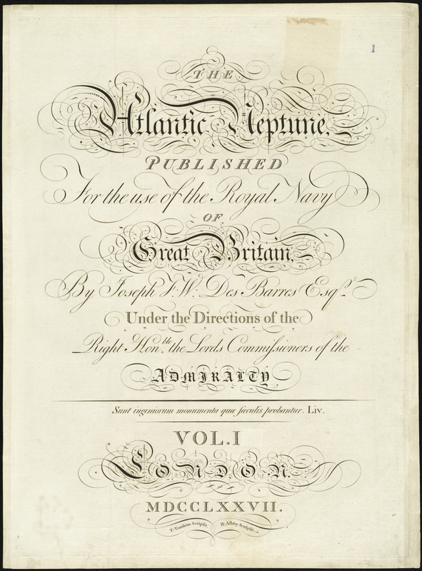
J.F.W. Des Barres
[Title page for volume one, The Atlantic Neptune]
1777.
In addition to containing meticulously prepared and scientifically derived charts, The Atlantic Neptune is a truly beautiful work, incorporating aesthetically pleasing design elements throughout its pages. From the very first page, the reader is astonished by the elaborate and ornamental calligraphy work of T. Tomkins, as seen in this 1777 title sheet for volume one. Popular in the 18th century, this handwriting executed in the decorative Rococo style, is a prelude to other artistically arranged design elements that appear in the charts and views.
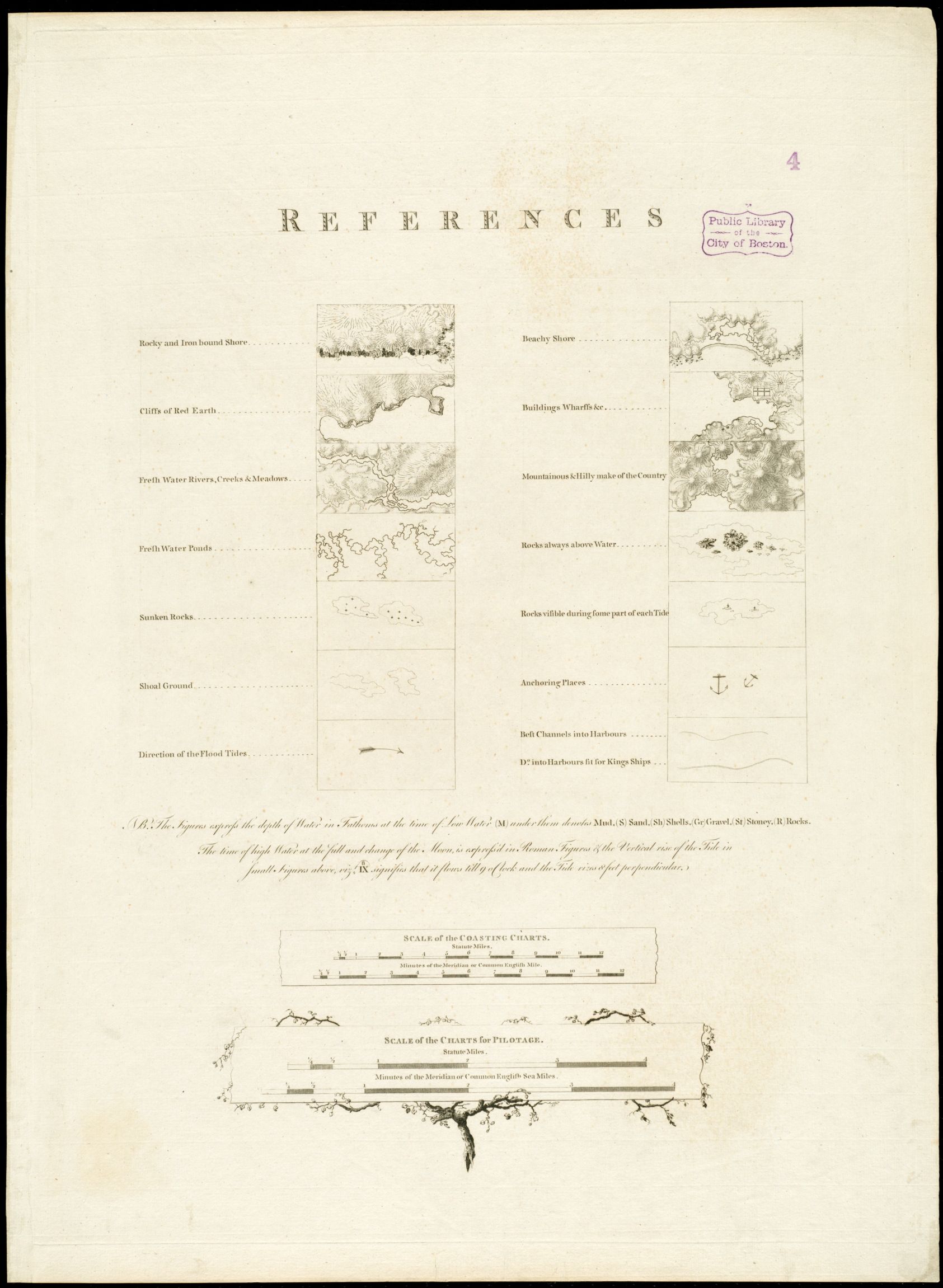
J.F.W. Des Barres
“References” from The Atlantic Neptune
1777.
Des Barres included a legend or sheet of “references” at the beginning of each volume of The Atlantic Neptune. This innovative and instructive sheet provided mariners with visual explanations to the various symbols used throughout the Neptune, as an understanding of the details illustrated on the charts was essential to safe navigation. The “references” contain descriptions of coastal topography, directions of tides, and locations of underwater dangers and anchoring places, in an attempt to better serve the navigators who would use the charts to sail along the North American coast.
5. Models and Equipment
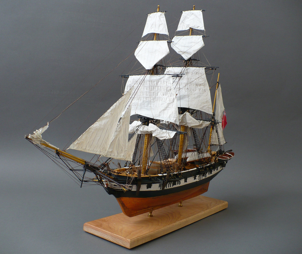
Tony Mallia
HM Survey Ship Beagle (1831), 1:64 model
2009.
Courtesy Tony Mallia.
Survey ships, similar to this model, were used by the British Admiralty in the 1760s to collect hydrographic data in the coastal waters of North America. This was Britain’s first major nautical project as they surveyed new territories gained following their victory in the French and Indian War.
The HMS Beagle, seen here, first launched in 1820 and was later adapted as a survey ship. She was used by the British to survey the southern part of South America and Oceania in the 1820s and 1830s. Charles Darwin, the naturalist, was a member of the Beagle’s second expedition.
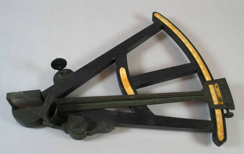
Octant
First half of 19th century. Ebony, brass, ivory.
Courtesy USS Constitution Museum. USSCM Cat. #172.1
An octant was used to find one’s location north or south of the equator while at sea. Two mirrors– one fixed, the other moveable– bring the image of the sun into the direct view of the horizon. Measurements were compiled into nautical almanacs.
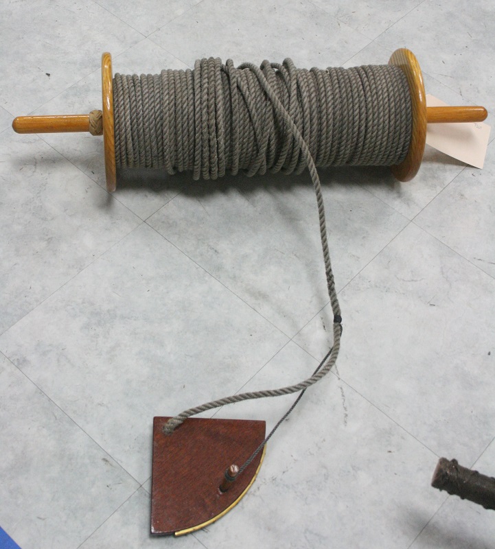
Greg Germain
Common log reproduction
Marblehead, MA, 1997. Mahogany, pine, natural fiber line.
Courtesy Naval History & Heritage Command Detachment Boston.
First used by mariners in the 15th century, the common or chip log is a device which measures the speed of a ship through water, or the distance the ship has traveled in a given time. A 28-second sand glass was used in conjunction with the log, to record the speed. The log, or chip – a flat piece of board – was fastened to a long line, which was divided into uniform spaces called knots, and was wound onto a reel. Knots were spaced every 48 feet (8 fathoms) along the line, and were proportional to the number of times 28-second intervals occurred in an hour. This method of measuring speed would have been used by the British navigating to the North American empire, and was used until the early 20th century.
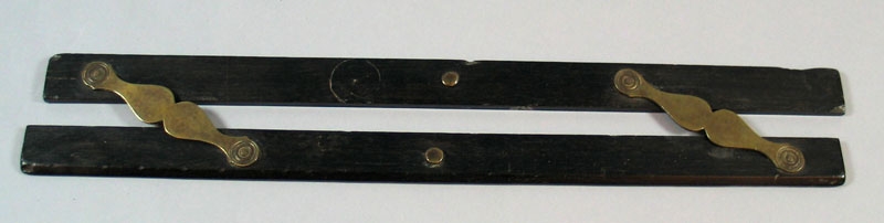
Parallel Rule
19th century. Ebony and brass.
Courtesy USS Constitution Museum. USSCM Cat. #295.1
The parallel rule is used to draw parallel lines, which is important in laying off a specific course on a chart. Parallel rules are still used by navigators today.
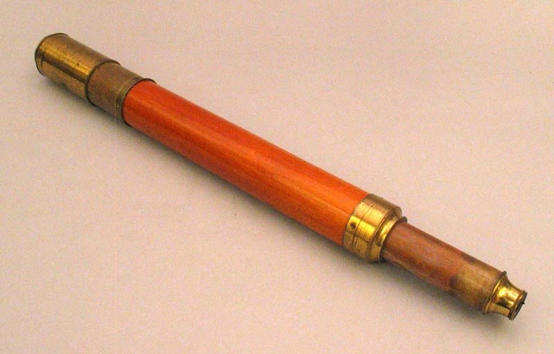
Telescope
19th century. Mahogany, glass, brass.
Courtesy USS Constitution Museum. USSCM Cat. #1050.3a; USSCM Cat. #265.1
This telescope has a single draw tube with brass fittings. Telescopes like this were commonly used on board ships in the 19th century for making general observations.
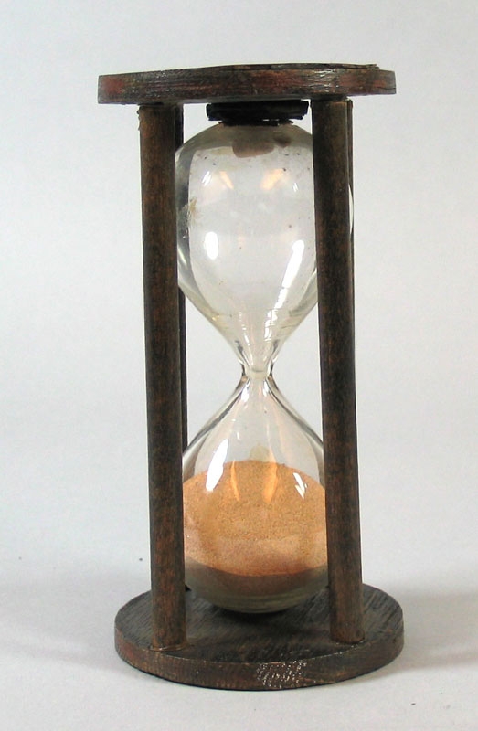
30 minute glass
ca. 1900. Glass, wood, sand.
Courtesy USS Constitution Museum. USSCM Cat. #176.1
The 30 minute sand glass, also called a watch glass, was used to measure the time at sea. The glass would be turned every half hour, and was used in conjunction with the ship’s bell.
Exhibition Photos
Bibliography
Bishop, Roy L. “J.F.W. DesBarres: an Eighteenth-Century Nova Scotia Observatory.” In Profiles of Science and Society in the Maritimes prior to 1914, edited by Paul A. Bogaard, 65-81. Fredericton, N.B.: Acadiensis Press, 1990. [BPL Call #: Q127 .C2P76 1990x].
Bowditch, Nathaniel. “Marine Surveying.” In American Practical Navigator: An Epitome of Navigation, 131-141. Washington: U.S. Govt. 1966. Accessed March 14, 2013. http://www.archive.org.
Brown, Lloyd A. “The Atlantic Neptune.” The Pennsylvania Magazine of History and Biography Vol. 67, No. 4 (October 1943): 377-381. Accessed September 1, 2013. http://www.jstor.org/stable/20087626.
Bumsted, J.M. “The Origins of the Land Question on Prince Edward Island, 1767-1805.” Acadiensis Vol. 11, No. 1 (Autumn/Fall 1981): 43-56. Accessed September 1, 2013. http://www.jstor.org/stable/30302713.
Cohen, Paul E. and Robert T. Augustyn. Manhattan in Maps: 1527-1995. New York: Rizzoli, 1997. [BPL Call #: G1254.N42S1 .C6 1997].
Concannon, John. “What’s the Importance of the Gaspee Affair?” Gaspee Virtual Archives. Accessed January 8, 2013. http://gaspee.org/WhatstheImportance.html.
Crowley, John E. “A Visual Empire: Seeing the British Atlantic World from a Global British Perspective.” In The Creation of the British Atlantic World, 283-303. Baltimore: The Johns Hopkins University Press, 2005. [BPL Call #: E188.C89 2005].
Cumming, William P. The Southeast in Early Maps. Chapel Hill, N.C.: The University of North Carolina Press, 1998. [BPL Call #: GA405.C8 1998]
De Vorsey Jr., Louis. “La Florida Revealed: The De Brahm Surveys of British East Florida, 1765-1771.” In Pattern and Process: Research in Historical Geography. Washington, D.C.: Howard University Press, 1975. [BPL Call #: E179.5.C58 1971].
Downey, Fairfax. “The Victors and the Spoils.” In Louisbourg: Key to a Continent, 109-118. Englewood Cliffs, N.J.: Prentice-Hall, 1965. [BPL Call #: F1039.5 .L8D6].
Dubowsky, Nathan and Scott Michael Dubowsky. “The Final Mission of ‘HMS Beagle’: Clarifying the Historical Record.” The British Journal for the History of Science Vol. 27, No 1 (March 1994): 105-111. Accessed March 27, 2013. http://www.jstor.org/stable/4027584.
Edgar, Walter. South Carolina: A History. Columbia, S.C.: University of South Carolina Press, 1998. [BPL Call #: F269.E34 1998].
Evans, G.N.D. Uncommon Obdurate: The Several Public Careers of J.F.W. DesBarres. Salem, MA.: Peabody Museum, 1969. [BPL Call #: F1032.D47 E86].
Harrison, Michelle. King Sugar: Jamaica, the Caribbean, and the World Sugar Industry. New York: New York University Press, 2001. [BPL Call #: HD9114.J252 H37 2001].
Homburger, Eric. The Historical Atlas of New York City: A Visual Celebration of Nearly 400 Years of New York City’s History. New York: Henry Holt and Company, 1994. [BPL Call #: F128.3.H65 1994].
Hornsby, Stephen J. British Atlantic, American Frontier: Spaces of Power in Early Modern British America. Hanover, N.H.: University of Press of New England, 2005. [BPL Call #: E40.5 .H67 2005].
Hornsby, Stephen J. Surveyors of Empire: Samuel Holland, J.F.W. Des Barres, and the Making of The Atlantic Neptune, Ithaca, N.Y.: McGill-Queen’s University Press, 2011.
Jefferys, C.P.B. Newport: A Short History. Newport, R.I.: Newport Historical Society, 1992. [BPL Call #: F89.N5 J44 1992].
Leamon, James S. “Falmouth, the American Revolution, and the Price of Moderation.” In Creating Portland: History and Place in Northern New England. Durham, N.H.: University of New Hampshire Press, 2005. [BPL Call #: F29.P9C73 2005].
Lotz, Jim and Pat Lotz. “History.” In Cape Breton Island, 43-53. Vancouver: Douglas, David & Charles, 1974.
Meinig, D.W. “Reorganization: Northern America.” In The Shaping of America: A Geographical Perspective on 500 years of History. Volume 1, Atlantic America, 1492-1800, 270-280. New Haven: Yale University Press, 1986.
Morrison, Walter K. “The Cartographical Revolution of 1775.” In Explorations in the History of Canadian Mapping: A Collection of Essays, edited by Barbara Farrell and Aileen Desbarats, 75-88. Ottawa: Association of Canadian Map Libraries and Archives, 1988.
Morrison, Walter K. “The ‘Modern’ Mapping of Nova Scotia.” The Map Collector 18 (March 1982): 28-34.
National Maritime Museum. “Atlantic Neptune Charts.” http://collections.rmg.co.uk/collections.html#!csearch;authority=subject-90437;collectionReference=subject-90437.
Newman, Edwin B. and Augustus P. Loring. “Some Notes on the Paper of the Atlantic Neptune.” The American Neptune: A Quarterly Journal of Maritime History 46, no.3 (Summer 1986): 173-178. [BPL Call #: PER V1.A4 vol. 46(3) 1986]
Outwin, Charles P.M. “Thriving and Elegant Town: Eighteenth-Century Portland as Commercial Center.” In Creating Portland: History and Place in Northern New England. Durham, N.H.: University of New Hampshire Press, 2005. [BPL Call #: F29.P9C73 2005].
Pedley, Mary. “Map Wars: The Role of Maps in the Nova Scotia/Acadia Boundary Disputes of 1750.” Imago Mundi Vol. 50 (1998): 96-104. Accessed February 20, 2013. http://www.jstor.org/stable/1151393.
Ristow, Walter W. “Maps of the American Revolution: A Preliminary Survey.” The Quarterly Journal of the Library of Congress Vol. 28, No. 3 (July 1971): 196-215. Accessed September 1, 2013. http://www.jstor.org/stable/29781478.
Saltonstall, William G. Ports of Piscataqua. Cambridge, Mass.: Harvard University Press, 1941. [BPL Call #: F42.P4 S3].
Sorrenson, Richard. “The Ship as a Scientific Instrument in the Eighteenth Century.” Science in the Field (1996): 221-236. Accessed March 23, 2013. http://www.jstor.org/stable/301933.
Struik, D. J. “Mathematicians at Ticonderoga.” The Scientific Monthly Vol. 82, No. 5 (May 1956): 236-240. Accessed February 20, 2013. http://www.jstor.org/stable/22216.
Terrell, Christopher. “A Sequel to The Atlantic Neptune of J.F.W. DesBarres: the story of copperplates.” The Map Collector 72 (Autumn 1995): 2-9.
Thompson, Don W. Men and Meridians: The History of Surveying and Mapping Canada. Volume I, Prior to 1867, 91-111. Ottawa: R. Duhamel, Queen’s Printer, 1966. [BPL Call #: TA523.A1 T47 v.1].
Thompson, Keith Stewart. “H.M.S. Beagle, 1820-1870.” American Scientist, Vol. 63, No. 6 (Nov.-Dec. 1975): 664-672. Accessed March 27, 2013. http://www.jstor.org/stable/27845783.
Varney, George J. “Machias.” In A Gazetteer of the State of Maine, 344-347. Boston: B.B. Russell, 1881. [BPL Call #: SOC SCI F17.V31].
Verner, Coolie. A Carto-bibliographical Study of The English Pilot: The Fourth Book with Special Reference to The Charts of Virginia. Charlottesville, Va.: University of Virginia Press, 1960.
Vickers, Daniel. Farmers & Fishermen: Two Centuries of Work in Essex County, Massachusetts, 1630-1850. Chapel Hill, N.C.: University of North Carolina Press, 1994. [BPL Call #: F72.E7 V58 1994].
Wahll, Andrew J. and Henry Mowat. Henry Mowat: voyage of the Canceaux 1764-1776, abridged logs of H.M. armed ship Canceaux. Bowie, MD.: Heritage Books, 2003.
Wall, Robert Emmet Jr. “Louisbourg, 1745.” The New England Quarterly, Vol. 37, No. 1 (March 1964): 64-83. Accessed February 20, 2013. http://www.jstor.org/stable/363191.
Webster, John Clarence. The Life of Joseph Frederick Wallet Des Barres. Shediac, N.B.: Privately printed, 1933. [BPL Call #: 4314.427].
Withey, Lynne. Urban Growth in Colonial Rhode Island: Newport and Providence in the Eighteenth Century. Albany: State University of New York Press, 1984. [BPL Call #: HT123.5.R4 W55 1984].
Credits
Stephanie Cyr
Norman B. Leventhal Map Center Staff
Lauren Chen, Cataloger
Alison Cody, Development and Program Manager
Stephanie Cyr, Assistant Curator of Maps
Ronald Grim, Curator of Maps
Janet Spitz, Executive Director
Evan Thornberry, Reference and
Preservation Librarian
Catherine Wood, Office Manager
Graphic Design and Production
Framing and Matting
Andrew Leonard
Anabel Vazquez Rodriguez
Digital and Web Services
Tom Blake
Bahadir Kavlakli
Lending Institutions
Richard H. Brown
Margherita M. Desy
Tony Mallia
Massachusetts Historical Society
Press
Top of the Charts: Charting an Empire: The Atlantic Neptune
Boston Globe, May 20, 2013
New Exhibition Opens at the BPL’s Norman B. Leventhal Map Center
BPL Press Release, May 3, 2013