Egmont Harbor
This map is also available in American Revolutionary Geographies Online (ARGO), a collections portal especially built for material relating to the American Revolutionary War Era. Visit ARGO to learn more about this item and explore the historical geography of North America in the late eighteenth century.
Item Information
- Title:
- Egmont Harbor
- Description:
-
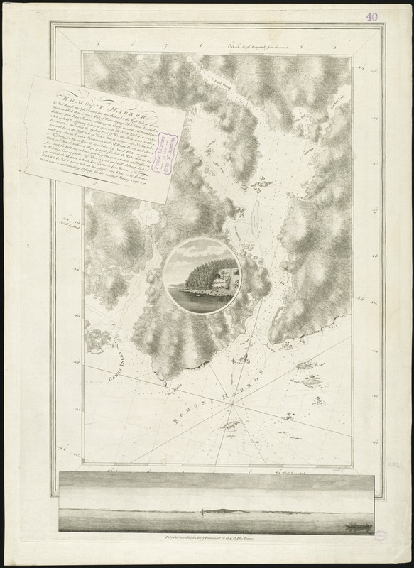
Des Barres, a Swiss-born army engineer and colleague of Samuel Holland, was tasked with surveying the coasts of Nova Scotia in 1764. This chart of Egmont Harbor (modern-day Jeddore Harbour, northeast of Halifax), is a fine example of the three types of visuals found throughout The Atlantic Neptune, as it combines a nautical chart with a coastal profile, and an illustrative vignette. Des Barres' thorough work of gathering soundings (measurements of depths) is seen here, and throughout the Neptune. These measurements, gathered according to the latest scientific standards, along with numerous sailing directions, helped navigators avoid underwater dangers near the coast.
- Creator:
- Des Barres, Joseph F. W. (Joseph Frederick Wallet), 1722-1824
- Date:
-
[1770–1779]
- Format:
-
Maps/Atlases
- Location:
-
Boston Public Library
Norman B. Leventhal Map & Education Center - Collection (local):
-
Norman B. Leventhal Map & Education Center Collection
- Subjects:
-
Nautical charts--Nova Scotia--Jeddore Harbour--Early works to 1800
Nautical charts--Nova Scotia--Early works to 1800
Coasts--Nova Scotia--Maps--Early works to 1800
Nova Scotia--Maps--Early works to 1800
Jeddore Harbour (N.S.)--Maps--Early works to 1800
- Places:
-
Jeddore Harbour
- Extent:
- 1 chart ; 58 x 37 cm, on sheet 78 x 57 cm.
- Terms of Use:
-
No known copyright restrictions.
No known restrictions on use.
- Publisher:
-
[London] :
J.F.W. Des Barres
- Scale:
-
Scale [ca. 1:28,000]
- Language:
-
English
- Notes:
-
Chart of present-day Jeddore Harbor and Musquodoboit Harbor.
Depths shown by soundings.
Oriented with north toward the upper right.
Appears in the author's Atlantic Neptune. London : J.F.W. Des Barres, 1777-[1781].
- Notes (date):
-
This date is inferred.
- Notes (exhibitions):
-
Exhibited: "Charting an Empire: The Atlantic Neptune" organized by the Norman B. Leventhal Map Center at the Boston Public Library, 2013.
- Identifier:
-
06_01_008278
- Call #:
-
G1106.P5 D47 1777
- Barcode:
-
30000003797529


