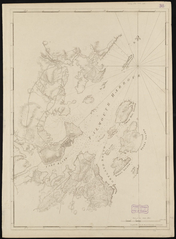
Falmouth Harbour
This map is also available in American Revolutionary Geographies Online (ARGO), a collections portal especially built for material relating to the American Revolutionary War Era. Visit ARGO to learn more about this item and explore the historical geography of North America in the late eighteenth century.
Item Information
- Title:
- Falmouth Harbour
- Description:
-
The town of Falmouth (present-day Portland, Me.) was the most important supplier of forest products in the British Empire before the American Revolutionary War. Falmouth's large harbor was well protected, was easily defendable and was adjacent to vast forests of white pine, all of which contributed to the town's commercial success. This 1777 chart of the region is the first state, or edition of the map, and it details the harbor islands, as well as inland topography, roads and settlements. By the dawn of the Revolutionary War, Britain was dependent on wood produced in the colonies, and Falmouth was a key component of the extensive lumber trade.
- Creator:
- Des Barres, Joseph F. W. (Joseph Frederick Wallet), 1722-1824
- Date:
-
[1770–1779]
- Format:
-
Maps/Atlases
- Location:
-
Boston Public Library
Norman B. Leventhal Map & Education Center - Collection (local):
-
Norman B. Leventhal Map & Education Center Collection
- Subjects:
-
Nautical charts--Maine--Portland Harbor--Early works to 1800
Portland Harbor (Me.)--Maps--Early works to 1800
- Places:
-
MaineCumberland (county)Portland Harbor
- Extent:
- 1 chart ; 75 x 54 cm.
- Terms of Use:
-
No known copyright restrictions.
No known restrictions on use.
- Publisher:
-
London :
J.F.W. Des Barres
- Edition:
- 1st state.
- Scale:
-
Scale [ca. 1:24,900]
- Language:
-
English
- Notes:
-
Title from published bibliography.
Relief shown by hachures. Depths shown by soundings.
Appears in the author's Atlantic Neptune. London : J.F.W. Des Barres, 1777-[1781].
- Notes (date):
-
This date is inferred.
- Notes (exhibitions):
-
Exhibited: "Charting an Empire: The Atlantic Neptune" organized by the Norman B. Leventhal Map Center at the Boston Public Library, 2013.
- Identifier:
-
06_01_004978
- Call #:
-
G1106.P5 D47 1777
- Barcode:
-
30000003808290


