Toggle navigation
LMEC Home
Exhibitions
Georeferencing
Tools for Teachers
Collections
My Favorites
Sign Up / Log In
Search
Search the map portal
Map Collection
Map Collection
Map Sets
Search
Search
Search for
Search In
All Fields
Creator
Title
Subject
Place
Search All Digital Collections
Advanced Search
135 Results
My Search
Start Over
half
Remove constraint half
Filter your Search
Place
North and Central America
92
United States
89
Boston
37
Suffolk (county)
35
Canada
9
Massachusetts
9
World
9
Europe
6
more
Place
»
Topic
Boston (Mass.)--Maps
25
United States--Maps
9
World maps
6
Boston (Mass.)--Aerial views
5
Railroads--United States--Maps
3
Africa--Maps--Early works to 1800
2
Boston (England)--Maps
2
Boston (Mass.)--Buildings, structures, etc--Maps--Early works to 1800
2
more
Topic
»
Date
Date range begin
–
Date range end
Current results range from
1482
to
1988
View distribution
Creator
Sampson, Davenport & Co
10
Sampson, Murdock & Co
9
Amherst, Jeffery Amherst, Baron, 1717-1797
3
George, III, King of Great Britain, 1738-1820
3
George, IV, King of Great Britain, 1762-1830
3
O.H. Bailey & Co
3
Royal United Services Institute for Defence and Security Studies
3
Bachmann, John, fl. 1849-1885
2
more
Creator
»
Format
Maps/Atlases
132
Manuscripts
10
Prints
3
Georeferenced
Yes
23
No
112
Collection
Norman B. Leventhal Map Center Collection
109
Boston and New England Maps
46
Urban Maps
41
American Revolutionary War-Era Maps
27
British Library Collection
8
Mapping Boston Collection
7
Library of Congress Collection
4
MacLean Collection Map Library
4
more
Collection
»
Available to use
No known restrictions
103
Creative Commons license
23
Search Constraints
Sort by relevance
relevance
title
date (asc)
date (desc)
Number of results to display per page
20 per page
10
per page
20
per page
50
per page
100
per page
View results as:
grid view
map view
Search Results
1.
[Chart of Nantucket Island and the eastern half of Martha's Vineyard]
2.
Map of Boston and adjacent country showing that city to be the geographical as well as intellectual and moral centre of one...
3.
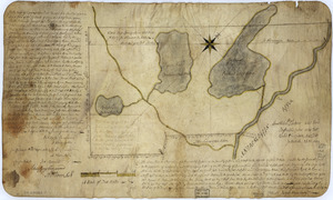
The above plan is a discription of a new township containing the quantity of seven and a half mile of land & water, granted by...
4.
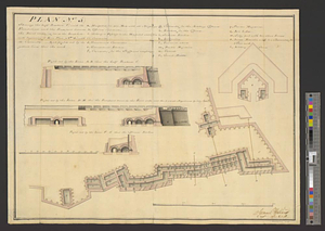
Plan (no. 5) shewing the half bastion C with its foundations and the rampart towards the river side, as far as the loop-hole...
5.
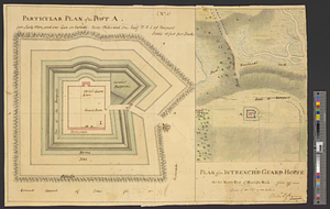
Plan of an intrench'd guard house at the north end of Howlands Neck, June 1777
6.
Copy of a survey return'd by Mr. Sam Lewis, surveyor of Botetourt Coun[t]y : Surveyed for George Washington 2950 acres of land...
7.
Charlestown Navy Yard area
8.
Physical map of the Crimea, with enlarged maps of the seat of war and views of Sebastopol & Balaklava
9.
Map of the city of New-York extending northward to Fiftieth Street
10.
Skeleton map showing the rail roads completed and in progress in the United States and their connection as proposed with the...
11.
The Seat of war, in New England
12.
Map of the existing and proposed circumferential thoroughfares of the district
13.
Porto Rico and Virgin Isles : Haiti, Hispaniola or St. Domingo
14.
The coast of Nova Scotia, New England, New-York, Jersey, the Gulph and River of St. Lawrence : the islands of Newfoundland,...
15.
The city of Boston
16.
A map of North America, denoting the boundaries of the yearly meetings of Friends and the locations of the various Indian tribes
17.
Mappemonde projetée sur l'horizon d'Angers
18.
Birds eye view of the White Mountains
19.
Boston Harbour : from the survey of A.S. Wadsworth, Esq., U.S.N. and the chart of Des Barres
20.
Carte des Etats-Unis de l'Amérique-Nord : pour servir aux observations géologiqueir
‹ Prev
Next ›
1
2
3
4
5
6
7
![[Chart of Nantucket Island and the eastern half of Martha's Vineyard]](https://bpldcassets.blob.core.windows.net/derivatives/images/commonwealth:7h149z54k/image_thumbnail_300.jpg)

![Copy of a survey return'd by Mr. Sam Lewis, surveyor of Botetourt Coun[t]y](https://bpldcassets.blob.core.windows.net/derivatives/images/commonwealth:q524nf40r/image_thumbnail_300.jpg)


