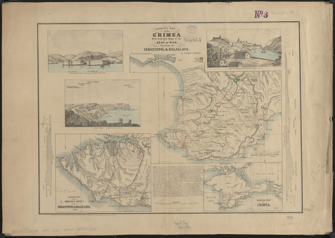
Physical map of the Crimea, with enlarged maps of the seat of war and views of Sebastopol & Balaklava
Item Information
- Title:
- Physical map of the Crimea, with enlarged maps of the seat of war and views of Sebastopol & Balaklava
- Cartographer:
- Sandoz, Ernest
- Lithographer:
- S.W. Chandler & Bro.
- Publisher:
- John P. Jewett and Company (Boston, Mass.)
- Name on Item:
-
from the best authorities by Ernest Sandoz
- Date:
-
1854
- Format:
-
Maps/Atlases
- Location:
-
Boston Public Library
Norman B. Leventhal Map & Education Center - Collection (local):
-
Norman B. Leventhal Map & Education Center Collection
- Subjects:
-
Crimean War, 1853-1856--Maps
Crimea (Ukraine)--Maps
- Places:
-
UkraineCrimea (area)
- Extent:
- 3 maps on 1 sheet : hand color ; 35 x 49 cm
- Terms of Use:
-
No known copyright restrictions.
No known restrictions on use.
- Publisher:
-
Boston :
Published by John P. Jewett & Company
- Scale:
-
Scale approximately 1:114,000
Scale approximately 1:410,000
Scale approximately 1:2,750,000
- Language:
-
English
- Table of Contents:
-
No. 1. [Southwestern half of the highlands]
No. 2. Enlarged map of the immediate vicinity of Sebastopol & Balaklava
No. 3. General map of Crimea.
- Notes:
-
Colored to show army positions.
Relief shown by hachures.
Includes text, 3 views and 2 vertical profiles.
"This map is highly approved by Professors Guyot & Agassiz of Cambridge in their letters."
- Identifier:
-
06_01_015178
- Call #:
-
G7103.C7S54 1854 .S36
- Barcode:
-
39999085932497