Toggle navigation
LMEC Home
Exhibitions
Georeferencing
Tools for Teachers
Collections
My Favorites
Sign Up / Log In
Search
Search the map portal
Map Collection
Map Collection
Map Sets
Search
Search
Search for
Search In
All Fields
Creator
Title
Subject
Place
Search All Digital Collections
Advanced Search
46 Results
My Search
Start Over
1845
Remove constraint 1845
Filter your Search
Place
North and Central America
35
United States
31
Massachusetts
9
Europe
7
Boston
5
Suffolk (county)
5
Middlesex (county)
4
New England
3
more
Place
»
Topic
Boston (Mass.)--Maps
2
Bunker Hill, Battle of, Boston, Mass., 1775--Maps, Manuscript--Early works to 1800
2
New England--Maps
2
United States--Maps
2
1844
1
Aqueducts--Massachusetts--Cochituate, Lake--Maps
1
Aqueducts--Massachusetts--Spot Pond (Stoneham)--Maps
1
Beacon Hill (Boston, Mass.)
1
more
Topic
»
Date
Date range begin
–
Date range end
Current results range from
1768
to
1906
View distribution
Creator
Bache, A. D. (Alexander Dallas), 1806-1867
3
Hassler, F. R. (Ferdinand Rudolph), 1770-1843
2
U.S. Coast and Geodetic Survey
2
United States. Hydrographic Office
2
Wadsworth, Alexander, 1806-1898
2
Alden, Albert.
1
Beaufort, Francis, Sir, 1774-1857
1
Bembé, Guillaume
1
more
Creator
»
Format
Maps/Atlases
46
Manuscripts
2
Georeferenced
Yes
6
No
40
Collection
Norman B. Leventhal Map & Education Center Collection
34
Boston and New England Maps
10
American Revolutionary War-Era Maps
7
Urban Maps
7
Maritime Charts and Atlases
4
Lucius Beebe Memorial Library Historic Maps
2
New York Public Library Collection
2
Robert E. Diefenbach Map Collection at Phillips Academy
2
more
Collection
»
Available to use
No known restrictions
40
Creative Commons license
5
Search Constraints
Sort by title
relevance
title
date (asc)
date (desc)
Number of results to display per page
20 per page
10
per page
20
per page
50
per page
100
per page
View results as:
grid view
map view
Search Results
1.
7th map to accompany Willards History of the United States
2.
Alden's pictorial map of the United States of North America
3.
Carta geografica general de la republica Mexicana
4.
Chart of Long Pond ; Chart of Spot Pond
5.
Coast chart no. 186 : Choctawhatchee Inlet to Pensacola Entrance, West Florida : report of Navy Yard Site Commission, Gulf of...
6.
Copy of a plan of South Bay
7.
Deutschland, königr. der Niederlande, kgr. Belgien und die Schweiz, nebst theilen der angränzenden länder nach Adolf...
8.
Eisen-bahn-karte von Deutschland und den angrenzenden ländern : zugleich als übersicht aller wichtigsten land- und...
9.
An exact plan of the sea coast of the continent from Paucatuck River eastwards to Point Judith and from thence northwards to...
10.
Exacta & accurata delineatio cùm orarum maritimarum tùm etjam locorum terrestrium qvæ in regionibus China, Cauchinchina,...
11.
France, Mediterranean coast : from the Pilote Français 1845 ; republication of Brit. Admty. chart no. 2609, with additions and...
12.
Head of Green Bay and entrance to Fox River, Wisconsin : from surveys under the direction of the Bureau of Topographical...
13.
Ireland, from the best authorities : with distances in miles from Dublin
14.
Location of the Boston & Maine extension rail road : from Boston to Wilmington
15.
Map of an exploring expedition to the Rocky Mountains in the year 1842 and to Oregon & north California in the years 1843-44
16.
Map of Liberia
17.
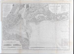
Map of New-York Bay and Harbor and the environs : [with colored manuscript additions to show positions of troops and fleets at...
18.
Map of New-York Bay and Harbor and the environs : Founded upon a trigonometrical survey under the direction of F.R. Hassler,...
19.
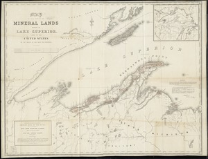
Map of that part of the mineral lands adjacent to Lake Superior, ceded to the United States by the treaty of 1842 with the...
20.
Map of the country copied from Hale's map of N. E. with railroad route from Boston to Lake Champlain : through Keene, N. H
‹ Prev
Next ›
1
2
3